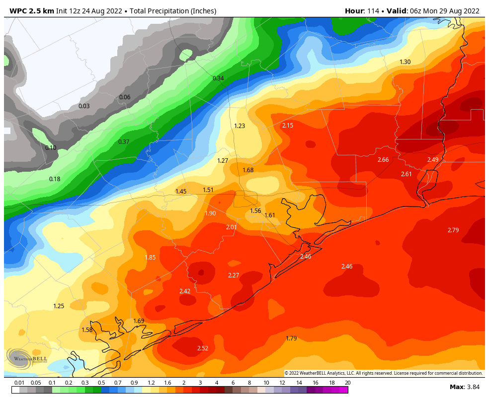
Good morning. Houston’s wet pattern will persist for awhile, but today and Thursday offer the best chances for widespread and heavy rainfall before the precipitation eases back just a bit. Overall we don’t have any real concerns for significant flooding, but we should continue to see the potential for some street flooding beneath the stronger storms. Additionally, we will need to monitor the tropics over the next month, as there are indications that the Atlantic is waking from its long slumber.
Wednesday
Showers will be likely today across the region, with the potential for more widespread rainfall closer to the coast, south of Interstate 10, where the most atmospheric moisture will be. I think much of the region will pick up between 0.25 and 1 inch of rain today, with totals greater the further south one goes. Some isolated areas could pick up 2 to 4 inches within the stronger and slower moving storms. Mostly cloudy skies should help to limit high temperatures to the upper 80s to 90 degrees, and winds will generally be light out of the southwest. Basically, this is a day when you want to check the radar before heading out of doors, just to make sure nothing too intense is headed your way. Rain chances will slacken this evening, with the loss of daytime heating.
Thursday
This should be a day similar to Wednesday in terms of the overall setup, I just don’t expect showers to be quite as widespread, nor the rainfall quite as heavy. The focus should again be closer to the coast for the stronger showers. For now, I’m thinking ‘Wednesday lite’ in terms of stormy weather, with highs for most of the region reaching about 90 degrees.
Friday, Saturday, and Sunday
Overall, Houston will remain in a pattern favorable for additional rain through the weekend. What should change is that some of the factors that favor heavy rainfall should start to wane, so that we enter a situation where showers spin up and then quickly move along. So for this weekend I think we’re probably looking at partly sunny skies, highs in the 90 to 95-degree range, and perhaps 50 to 70 percent chance of rain. Again I don’t think these won’t be all-day kinds of rains, but you should at least be planning for the potential of a passing shower.
Next week
We’re unlikely to see the return of high pressure next week, so we should see see temperatures continue in the 90 to 95-degree range, with a decent chance of showers during the daytime, and less so at night. It now looks as if this pattern will persist into early September. If you’re wondering whether there’s any hint of fall’s first real front in the medium-range models, the answer is, alas, no. I’ll be a summer bummer and say it is not time for fall yet.
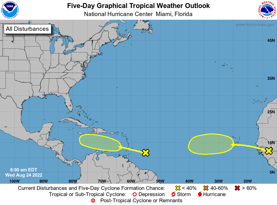
Tropics
It is time, however, to start watching the tropics. While there is a tropical wave in the deep Atlantic showing signs of life, for the Gulf of Mexico our focus should be on a low pressure system that will move into the Caribbean Sea later this week. There is now a decent amount of support in the ensembles of the GFS and European models for this to potentially develop into a tropical storm next week. The obvious question is, where will it go after that? Expect to see some social media noise during the next couple of days because the operational run of the GFS model, for the last few runs, has been bringing a fairly strong tropical system to the northern Gulf of Mexico coast late next week. However there are a very, very broad range of outcomes here, and the scenario with the most support right now would see a weaker tropical system that tracks more westward, into the Yucatan Peninsula and Mexico. So really, anything can happen.
The bottom line is that this is a system for us to watch at this point, and that should come as no surprise as we’re in the midst of the peak of the Atlantic hurricane season. For now, as usual, be wary but not worried.
when will i be able to pour foundation again?
Where’s the unrelenting high pressure when we need it? I want our shield back!
hell no
I really like your last words, “…be wary but not worried.” YUP…no “hype”…thanks…
Y’all got any more of that high pressure??
I am tired of the rain. The grass is growing but I can’t cut it–too wet. Houston is a mud pie. Who is hoping for cold fall weather already?
Well awhile back everyone wanted rain because of the drought
That’s because most people are never satisfied with anything. In order to cure a drought you need to have frequent rains that result in muddy soggy grounds. People complain when it doesn’t rain enough, but when it does they still complain because their yard is wet. The universe is not a perfect place, and most people don’t understand that. Humans want to have their cake and eat it to lol
Thank you, Thank you,
Read your reports every day. Can’t thank you enough.
Taylor R.
Keeping an eye on that one. We fly out on Tuesday to move our son to college in the northeast. Last thing I need is to worry about a hurricane at home.
You are really awesome, thank you for doing a fabulous job informing us! It’s much appreciated!
Hi. Isn’t it odd that the high temperatures are in the 80’s? This is Houston in August. Hello???