The high temperature on both Saturday and Sunday topped out at 90 degrees at Bush Intercontinental Airport, making for a warm weekend. If you’re tired of Houston’s long, long summer—the region had its first 90-degree day back on April 9 of this year—the good news is that we’re probably done with 90-degree days for 2019. In fact, we should mostly be in the 70s for this coming week and weekend.
Monday
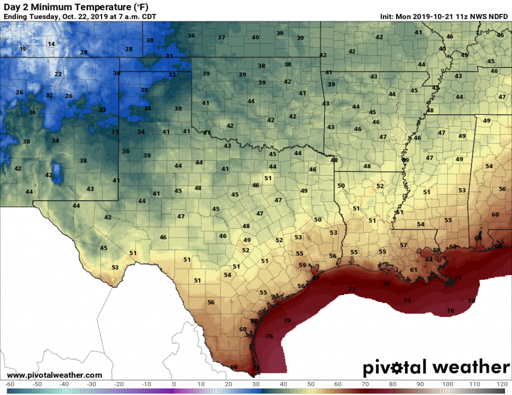
A line of storms will push through Houston at around sunrise, or a little before, on Monday morning. A few of these storms are fairly strong, but the line is moving from northwest to southeast fairly quickly, so we don’t have any flooding concerns. Most areas should see about one inch of rain. Unfortunately the storms will hit during the morning commute for some people. The front should be off the coast by or before noon. In the wake of the front, highs today should hold in the 70s, with most of Houston falling into the upper 50s on Monday night with clearing skies.
Tuesday and Wednesday
These will be a pair of gorgeous days, with cool mornings in the upper 50s (except along the coast), mostly sunny skies, and highs in the upper 70s to possibly 80 degrees. An onshore flow resumes on Wednesday night, which should nudge lows into the mid-60s.

Thursday and Friday
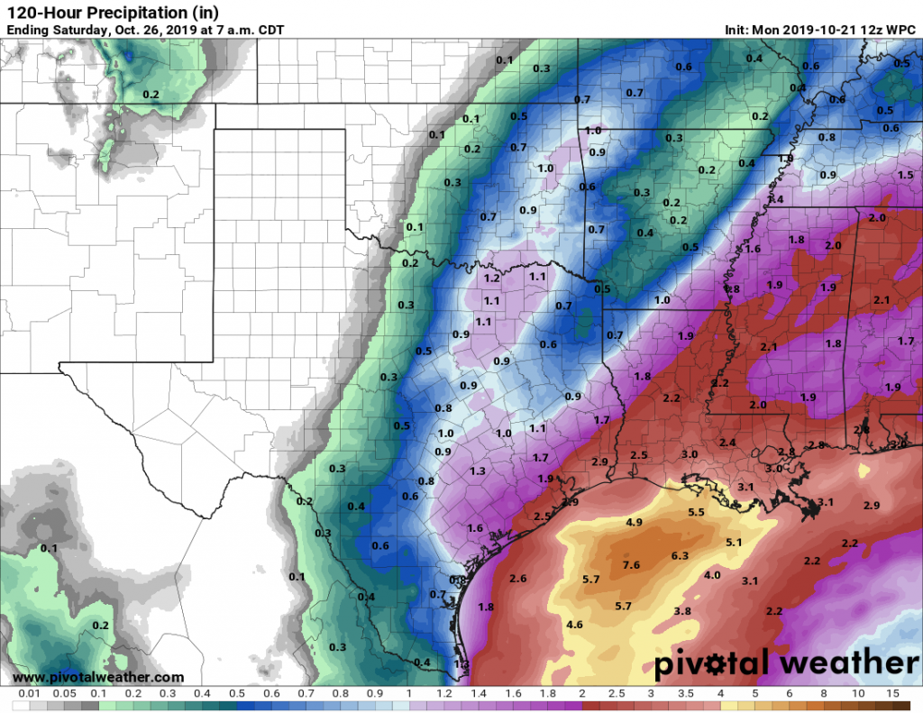
As moisture levels increase in the atmosphere, humidity and better rain chances will follow. With a mixture of clouds, highs aren’t going to get much above 80 degrees. However, it will be sticky, and with 60 to 70 percent rain chances by Thursday night most of the area probably can expect 0.5 to 2 inches of rain on Thursday and Friday ahead of the next front. Speaking of the front, it probably will arrive some time on Friday, Friday night, or Saturday morning—clearly the timing is not certain
Saturday and Sunday
Saturday’s weather will depend on the timing of the front, but at some point we’re going to transition from warm days of around 80 degrees to dry days with highs of around 70, and overnight lows possibly in the 40s for areas north and west of downtown Houston. After the front hits, Houston should see a really nice, and dry rest of the weekend.
Halloween
And what of Halloween? After this coming weekend’s front, we will likely see a warming trend for next week. Halloween comes on that Thursday. The weather for that day will depend on the timing of the third front from now, which likely will come perhaps a day before Halloween, or on the day itself. If its the latter, that could make for wet trick-or-treating, but it is simply way, way too early to have much confidence in a forecast.
90 degree weather in October can shove it.
100 percent agreed.
Saturday was one of the hotter Wings Over Houston in a few years – especially sitting out on the concrete baked by the sun. Really bad from about 11-2 until some more clouds moved in.
But at least it was not as bad as the first WOH back in 1985 – held in late August with resulting multiple heat stress cases among the audience.
Note to WOH staff – with summer lasting longer in Houston these days, how about moving the airshow to the first weekend in November?
The first weekend in November is usually opening weekend of deer season. I don’t want to have to make that choice.
Hopefully the heat was just a fluke. I go to the airshow every year, and it is usually cold, or at least cooler. I wonder if anyone has statistics about the weather during the airshow.
Maybe two guys who run a weather web site in Houston?
Hi Eric, why do you say that we don’t have concerns with flood with the storm moving northwest to southeast? Thanks for the blog, this is a weekly must read.
Rain started here at about 4PM with some lightning and thunder, and still raining at 8:30
On the west end of Galveston Island in Pirates Cove we are experiencing heavy rain (+1.5 inches )and very high tides in Galveston Bay which are driven by high wind. The bay flooding is currently as high as in Harvey. 9:00 am
4.25 inches in lovely Alvin
3.3″ in not-so-lovely-anymore Clear Lake
Roof open or closed Tues/Wed?
I have never seen a rhyme or reason for opening the roof. I found this for minute maid park but not sure if it is true.
“The roof is closed for the threat of rain, threat of sustained winds above 30 mph, temperatures below 65 degrees for a night game and air temperature or heat-index readings above 88 degrees for a night game or 84 for a day game.”
They want it closed for NOISE!
If your team being in the WS isn’t cause enough to be loud, open or closed, then you’re doing it wrong. Seahawks’ fans get plenty loud in an open-air stadium.
Open the roof. Noise in baseball is not the same as football. By the way the roof was open for the Colts game in Indy yesterday
Yeah, but look who the Colts competition was….
I know it’s not directly relevant to our weather here in Houston, but I would love to read a post about the tornado outbreak in Dallas last night if either of you has the time to write one. I’ve been reading lots of coverage of the storm from local Dallas news stations but I haven’t seen a good in-depth meteorological overview of the event. Just an idea! Thanks for everything you do, guys.
I say let’s go with the GFS model!