A quiet morning should transition into another quiet day for Houston, but rumblings remain on the horizon, though unfortunately clarity has not increased much more today.
TODAY
No big issues are anticipated for Friday, with highs in the low 80s and a mix of sun and clouds after any morning low overcast or fog dissipates.
SATURDAY
The first phase in the transition to a more active, unsettled weather pattern unfolds tomorrow. Onshore winds off the Gulf will help pool atmospheric moisture over us. Dewpoints should jump into the upper 60s Saturday, with high temperatures in the upper 70s. It will feel a bit more humid. While a shower or very isolated storm can’t be ruled out, most of us should see quiet weather.
SUNDAY THROUGH MIDWEEK
Not much change today in the forecast for this period. We continue to see an upper level storm system approach us from the west, tapping into rich Gulf moisture (available moisture will be near record levels in this period). These sorts of events are difficult to communicate effectively sometimes, so I’ll try and answer some questions.
When will the rain fall? There will likely be a few periods of thunderstorms or showers between Sunday afternoon and Wednesday. It will not rain the entire time though. Right now, the period from Sunday afternoon into Tuesday stands the best chance for storms of the next 6-7 though.
How much rain will we see? You’re going to see a lot of rainfall maps (including the official NWS one below) over the next few days.
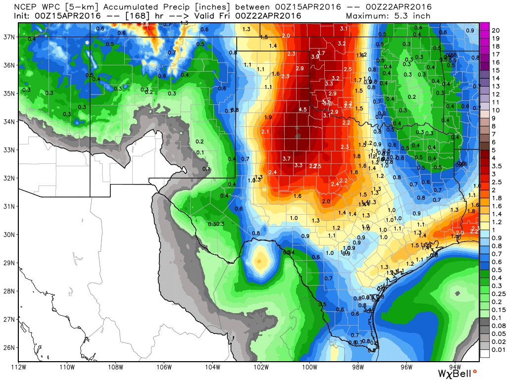
Some maps may show big numbers (particularly anyone showing the GFS model, which has been handing out double digit rain amounts southwest of Houston). It’s impossible for sure to say how much rain we see in this sort of situation, but we can use the weather models as guides. So if the models are painting regularly bullseyes of 10″+ of rain, we know potential is there for some significant totals. That said, the places actually seeing that much rain are likely to be isolated and small (10″ rain totals would be the exception rather than the rule). But I can’t tell you today whether it’s Baytown, Bay City, or Brenham that sees these big numbers. As of now, the trends imply that the best risk for this is south and west of Houston and probably south and west of the suburbs. That said, we won’t have high confidence as to where those places will be until about 24-36 hours before the storms hit. Eric’s call yesterday of an average of 2-5″ is about as good as we can do right now, knowing that some places will see quite a bit more. We’ll pin down exactly who that will be Sunday or next week.
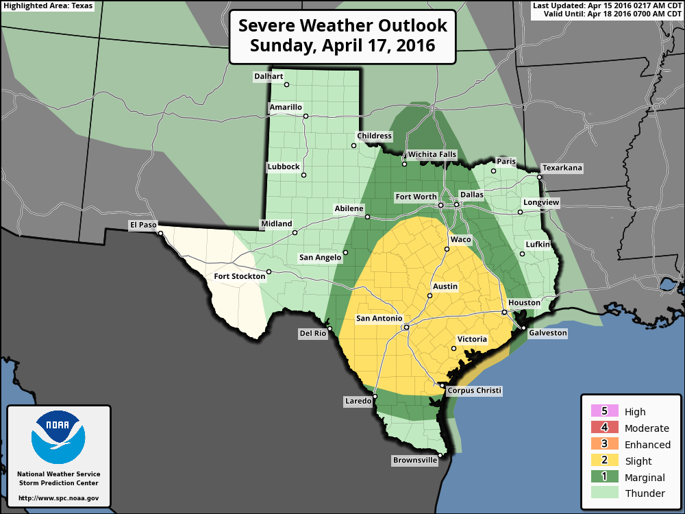
Will there be severe weather? As of right now, the Storm Prediction Center has areas west of Houston in a “slight” risk for Sunday, but hasn’t highlighted anyone for Monday and Tuesday as of yet.
From experience, these sorts of setups have four primary severe weather concerns. In order: Flooding, wind, lightning, hail. I think the focus should be on the rain and potential for localized flooding, but we will be watching for damaging winds in stronger storms, definitely a lot of lightning, and even some risk for a few hailers too. You always should have your guard up in spring, but I think the main headline in all this will ultimately be heavy rain and flooding potential.
When does this clear? I don’t think rain chances will leave the forecast much at all next week, but after Tuesday, weather models continue to imply quieter weather (so lower significant rain chances).
Advice: Keep tuned it over the weekend for updates on next week. Follow Eric or myself on Twitter too. We’ll hopefully be able to pin a few more details down by Sunday and certainly Monday morning. If you have plans early next week, don’t cancel, but run through some alternatives, and make sure to stay tuned to the forecast.
MS 150 RIDERS
Unfortunately no change in the MS150 forecast. Saturday should be good, with a solid tailwind. But Sunday will turn progressively stormy between La Grange and Austin, especially in the afternoon. Heavy rain is a good bet, and lightning is very possible. Officials are slated to update the status of the event by 10 A.M. this morning.