Hi all. You get Matt the next couple days. I just want to remind y’all about our annual fundraiser that’s underway through later this month. We have two cool t-shirt designs and umbrellas available to purchase if you’d like. The annual fundraiser helps support Eric and myself and our work keeping the site on time and online. Regardless, we appreciate your kind words and support throughout the year, and we are thrilled you choose us as a vehicle to stay informed.
On to the weather, and someone has to congratulate you for surviving the hottest November day on record in Houston. We hit 89° on Wednesday, which matches, with 9 other days, the hottest November maximum temperature on record in the city of Houston. The last time we hit 89 in November? Way back on November 6th of 2017. Almost a year to the day. The latest in November we’ve hit 89° would be on November 8th, done in back to back years of 1988 and 1989.
If you’re sick of the warm, ridiculously humid weather, we have good news. The end is pretty much here. Let’s walk through the forecast.
Today
We had quite the light show last night over parts of the Houston area.
About 90 seconds worth of lightning over #Houston condensed. Wow. #houwx pic.twitter.com/6l5ELoYpVf
— Matt Lanza (@mattlanza) November 8, 2018
In fact, some areas did receive over two inches of rain from the storms yesterday evening.
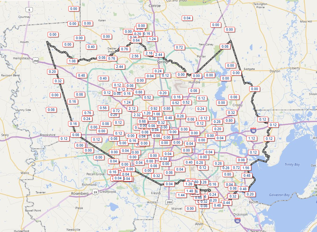
Some locally heavy rains also fell south of Houston. With the exception of a handful of remaining showers, it’s now quiet this morning. The cold front responsible for last night’s noisy storms is now sitting offshore. It’s still a bit humid, so southern parts of our area will have patchy dense fog to deal with this morning.
Otherwise, I would expect a good bit of cloud cover today, along with a chance for some lighter rain, drizzle, or showers at times. No serious weather is expected though. It will be noticeably cooler today with high temperatures probably not getting much past the low-70s in Houston. Areas south of Houston could still push mid-to upper-70s however.
Tonight & Friday
The next cold front arrives in the Houston area tonight. As it does so, expect showers and some embedded stronger thunderstorms to accompany it on its move south. The front should arrive in the far northern suburbs around midnight, give or take a couple hours, into the Houston area after 1-3 AM, and to the coast after 3-5 AM. Unlike our cold front last week, this edition will not come with a sharp, quick clearing line. In fact, the atmosphere behind tonight’s front will remain chilly, cloudy, and damp into much of Friday. Expect showers, perhaps a thunderstorm, and periods of light rain or drizzle along with a stiff north breeze during the day Friday. We should see around one to two inches of additional rainfall with this front.
Temperatures will remain mired in the 50s most of the day. Rain chances should dwindle as we get toward evening.

Weekend
If we’re placing odds on the best weekend day, it’s likely to be Saturday. The chance of rain isn’t zero on Saturday, but it looks relatively low right now. Expect mostly cloudy skies with temperatures warming from the 40s in the morning into the middle 50s in the afternoon.
Sunday begins our descent into our first taste of winter. Look for scattered showers and a chance of thunderstorms Sunday. Details are still a bit hazy at this point. Much will depend on exactly how a weak offshore system tracks. Right now, it looks to stay mostly offshore, keeping the highest rain chances south and east of Houston. If that shifts a bit, we could be talking warmer temps and higher rain chances elsewhere. For now, expect modest rain chances and temperatures warming from the upper 40s into the mid- to upper-50s. Some 60s will be possible near the coast. Again, this could change. We’ll update tomorrow.
Next week
The details for next week are slowly becoming more clear. Look for a slightly warmer day Monday before a strong cold front plows through Monday night and Tuesday. Right now, it doesn’t appear to have a ton of punch to it, rain-wise. But it will have a huge punch, temperature-wise. After upper-50s or low-60s on Monday, look for low-40s Monday night, followed up by a cold, raw Tuesday with a strong, gusty northerly wind. We’ll likely not get much past the low-50s on Tuesday before our first real shot at 30s on Tuesday night and Wednesday morning.
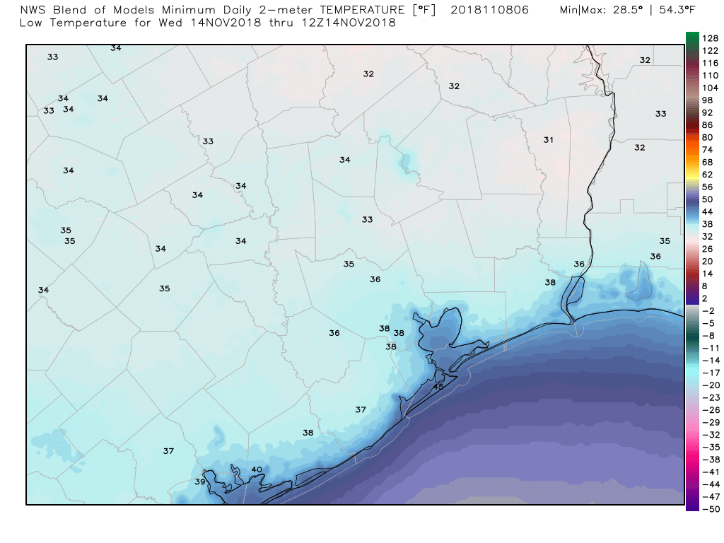
How cold will it ultimately get? We’ll see, but some modeling is rather aggressive in pushing us into the mid-30s (see above) or even a little colder Wednesday morning. For now, I’d expect a high chance we see at least upper-30s in the Greater Houston area. Unlike Friday’s front, there should be an aggressive push of drier air behind next week’s front. That means we will clear out the clouds and see a good bit of sunshine, but bundle up! More tomorrow.
After this week, highs in th 50s and lows in the upper 30s sounds cool (pordon the pun).
No it doesn’t
Are my tomatoes doomed to die next week? /sad
You know it’s chilly in Texas when you get your iced tea without the ice.
I did just that at lunch today.