7:40 pm CT Update: Just a quick post this evening on Hurricane Delta. The storm has intensified further since this afternoon, reaching maximum sustained winds of 145 mph at 7pm. However some wind shear in the mid-levels of the atmosphere has lately begun to affect Delta and may prevent further strengthening tonight, or even weaken the storm.
Regardless, Delta will bring devastating winds and storm surge to the Yucatan Peninsula later tonight and on Wednesday. After this time it will enter the Gulf and track west-northwest across the Gulf of Mexico. In terms of what happens after that, not much has changed with respect to the track forecast, which turns Delta north and brings a hurricane to the Gulf coast Friday evening or early Saturday—about three days from now. It seems the most likely location for this landfall will lie somewhere between the Texas-Louisiana border, on the western side, and Morgan City, on the eastern side. Even though we are within three days of landfall, some uncertainty remains, and this is reflected within the National Hurricane Center’s forecast cone.
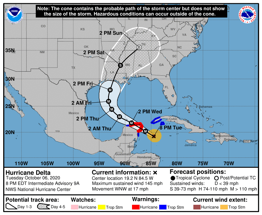
By tomorrow morning we should have a pretty good sense of the ultimate track forecast for Delta, as the overnight model runs ingest data from today’s aircraft reconnaissance missions as well as supplemental weather balloons to sample the atmosphere helping to control the steering flow for this system. The odds still strongly favor a landfall in southwest or south-central Louisiana, but there is enough uncertainty that we’re going to need to continue to watch Delta closely along the upper Texas coast.
That’s just what we’ll do, of course. In tomorrow morning’s post, which will go up no later than 7:30am, we’ll have the latest on track and potential impacts along the upper Texas coast later this week, as well as Louisiana.

Thank you!!!! Only way to get weather information. You actually lessen my anxiety.
Thanks guys! I feel like you guys are having to go into extra innings this Hurricane Season!
Is it just me or have these hurricanes for this season become harder to predict? When 2/3 of the gulf states still have to be anxiously watching at two- three days out from landfall, it makes it harder for those who REALLY need to evacuate to find a vacant place to stay….2020 sucks!
Thanks guys. Much appreciated info as we get ready on Bolivar.
Correlating with early October 2005 and its Zeta grand finale, we should make it to Iota by November… whats your prediction Eric and Matt…or Black Hawks Fan for that matter?
Thank you guys as always for being so straight forward on the storms! GODSPEED gulf coast!
The hurricane season is starting to rival the pandemic for sheer persistence. Enough already on both scores.
After this hurricane season you guys deserve a big raise! How many “overtime” hours have y’all clocked now??!
You guys are awesome. Thank you so much for your meteorologic expertise and down-to-earth explanations. You two really are heroes and jewels in the Houston area weather forecast universe Thank you.
Would a Greek letter get “retired” from future use if the storm is particularly devastating? It would certainly get confusing in a future busy year if a letter was left out.
Thanks so much for all your work! There is a strange thing about Delta. On the satellite image there is no visible eye, even though it is a category 4 hurricane! Why would this be?
Friends from Missouri have adult children in Cancun. They are in a shelter. Opinions on Cancun?
I am sooo over the 2020 hurricane season AND 2020 altogether. But, it does help knowing we have a couple of folks that try their dead level best to disseminate accurate weather info even when they have a few minor little distractions, like you know, bringing a new family member into the world.
Anyway, thanks guys and congrats Matt.