Houston has now gone six days without measurable rain—and we’re likely to add at least two more through Friday. The region hasn’t recorded a dry spell longer than five days since early January. It’s been nice—my yard is dry for the first time since I can’t even remember this winter. However we could now use a bit of rain, especially with tree pollen levels so high, and I’m not sure we’re going to get all that much in the days ahead. In fact, this March is likely to see much less rainfall than normal.
Thursday
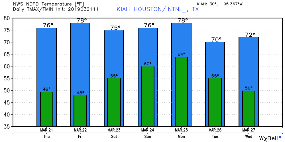
For today, there are no weather concerns. (If you’re in the Deer Park area, unfortunately, benzene levels are elevated in the aftermath of the toxic fire at an industrial facility. Please heed shelter-in-place warnings. Also, Highway 225 is closed in the region). Otherwise, today will be sunny, with high temperatures in the mid-70s, and lows tonight down around 50 degrees. A weak cold front crossed the region Wednesday night, which will keep our air dry for another day or so.
Friday
The onshore flow resumes during the day, so you’ll probably notice an uptick in humidity, and temperatures likely will get into the upper 70s. Overall this should still be a very pleasant day, however, with partly to mostly sunny skies. Lows Friday night probably won’t fall much below 60 degrees.

Saturday and Sunday
Do you have weekend plans? The forecast continues to be not too bad. Although moisture levels will be on the upswing due to the onshore flow, right now the weather models keep most precipitation well to the south of the area. As a result, I expect a pair of partly sunny days with highs between 75 and 80 degrees. Some brief showers will be possible, with perhaps the best chance coming Sunday afternoon, but most of the area will probably not see rain.
Monday and beyond
A cold front is still on schedule for passage Monday, but it no longer looks quite as strong, nor as wet, as previously. At this point I’d expect a broken (maybe a really broken) line of showers and perhaps thunderstorms to move through the region during the day, and bring a slight cool down to the region. Next week looks pretty nice again, with lots of 70s and sunshine. I’ll take it.
When might we expect the visible pollen accumulations to end?
We need a good, multi-inch rain to wash out the pollen and PMs from the fire out of the atmosphere.
Maybe if we are nice enough to Eric, he can make that happen?
NO ! NO ! NO!
No more rain…for at least another month or two…!!!