The weather pattern over Houston is making up for months and months of wet, dreary weather since last fall. As Eric alluded to yesterday, we’re going to end up below normal on rainfall for the month of March. I’ll take it one step further: Since late January, we have been exceedingly dry.
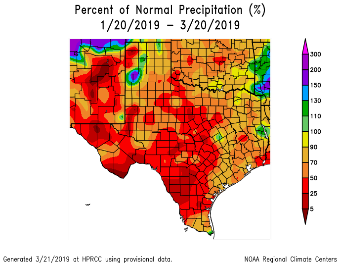
For Harris County, we have only averaged about 70 percent of what is normal over the last 60 days. Go a bit west of Houston, and parts of Central Texas from San Antonio through Austin are averaging about 50 percent or less of normal. Thanks to weeks and months of wet weather prior to the last 45-60 days, we are not in drought, nor are we even abnormally dry according to the latest Drought Monitor report. With an El Niño event ongoing and likely to continue, it would be surprising for this drier weather to continue (El Niño springs are usually fairly wet in Texas). But this will be a story to watch over the next few weeks.
Today
Unfortunately, our nicest week of the year so far has been marred by varying and unrelated forms of air quality issues. It has either been the situation in Deer Park with the ITC Terminal fire (which at least this morning seems under control), obscenely high levels of pollen, smoke from numerous agricultural fires across the Southeast leading to increased particulate matter, or as in today, high levels of ozone.
The Texas Commission on Environmental Quality has declared today an ozone action day, meaning we should see high levels of ozone and generally poor air quality. These types of days aren’t necessarily infrequent in Houston, but it’s just compounding our issues here of late. But, hey, other than that, it should be great today! Expect wall to wall sunshine with some passing high clouds today. We should manage upper-70s to around 80° in some spots.

Weekend
I would describe the weekend as “murky.” But it really won’t be all that bad. Onshore flow gets going this weekend, which will increase the humidity and rob us of our extremely pleasant nighttimes. Saturday morning will begin in the upper-50s to near 60°, and Sunday morning will begin in at least the low-60s.
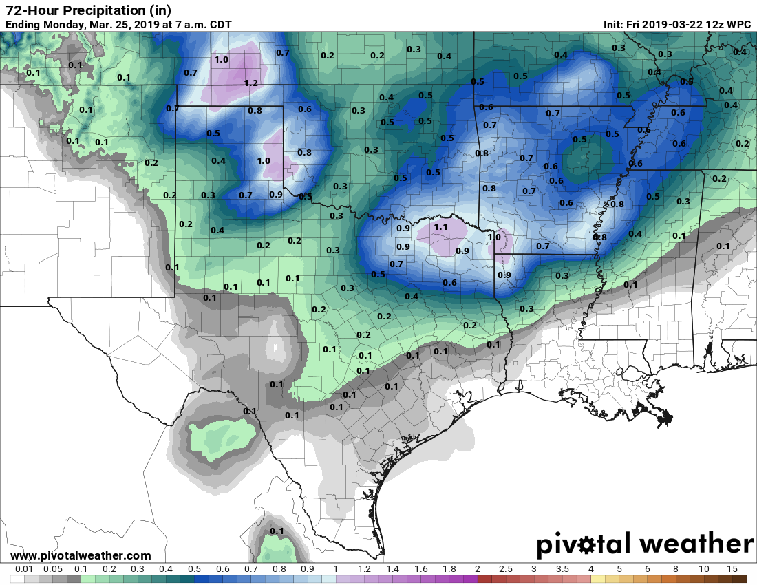
In terms of rain chances, they should be low but they will not be zero. Simply because of all the moisture coming ashore, those rain chances will increase. But we really lack a good “trigger” to get showers and storms going, so I would suspect that whatever forms will generally be light and spotty in nature. In fact, I would say most of us will remain dry this weekend. That said, a few places could receive a shower or storm, likely turning your neighborhood streets yellow with the heaping amounts of pollen covering everything in sight.
Anyway, I might say Saturday has a slightly better chance than Sunday for a passing shower. Either way, look for high temperatures to top off at 75 to 80° this weekend.
Next week
Monday should see an extension of the weekend weather with low-end shower chances and warm, humid weather. We should start the week in the mid-60s and finish Monday around 80° or so. A cold front will cross the region Monday night or early Tuesday, which should cool us just a little, but it will take a nice chunk out of the humidity. That sets up beautiful weather Tuesday and Wednesday, with lows in the 50s and highs in the 70s. Humidity and cloud cover should return for the latter part of the week, and our next rain chance will arrive by Friday or next weekend.
It’s almost as if the weather knows when the weekend is. 🤷♂️
Any thoughts on when tree pollen might drop off?
Hopefully over the next 10-14 days it begins to fall off.
I’m looking at Scheduling sod to be laid in my back yard starting next Friday. How bad do you think the rain will be over that weekend?
Too soon to say. Model projections range from meh to maybe risk for an inch or two in spots. But I can’t tell you where those spots will be this far out. This weekend’s minimal rains looked more impressive a week ago too, so I’m not going to be overly confident in what’s coming next weekend til Wednesday or so.
” But, hey, other than that, it should be great today! ”
In other words, you should go outside today to cough your lungs out.
El Nino may stick around for a while? If that’s the case, may it continue thru summer and, perhaps, reduce hurricane activity in the Gulf.
Possible? Yes. Definitely? No. Remember, we could have 3 storms all season, but if one of the three is a Cat 3 into Freeport, it’s a bad season for us.