Yes, there is a light at the end of the tunnel.
Unfortunately, that light is the Sun. And it’s going to be blazing hot and bright for the foreseeable future.
Sadly, if you are coming to this morning’s post looking for hope about Houston’s forecast, I can only offer a few crumbs. First of all, after this week, I think conditions may return to slightly more normal-ish weather for August. If that sounds hopeful, well, just remember that August in Houston is already pretty miserable. On the rain front we’re still looking at 5 to 10 percent daily chances this week, but by next week our daily rain chances may well jump up to about 30 percent a day, again a pattern more typical of high summer in Houston. Finally, our days are getting shorter. We have lost about 30 minutes of daylight since the summer solstice in late June, and that trend will accelerate in August. Houston is probably about six weeks away from having any expectation of the season’s first front. So some relief is coming—eventually.
Monday and Tuesday
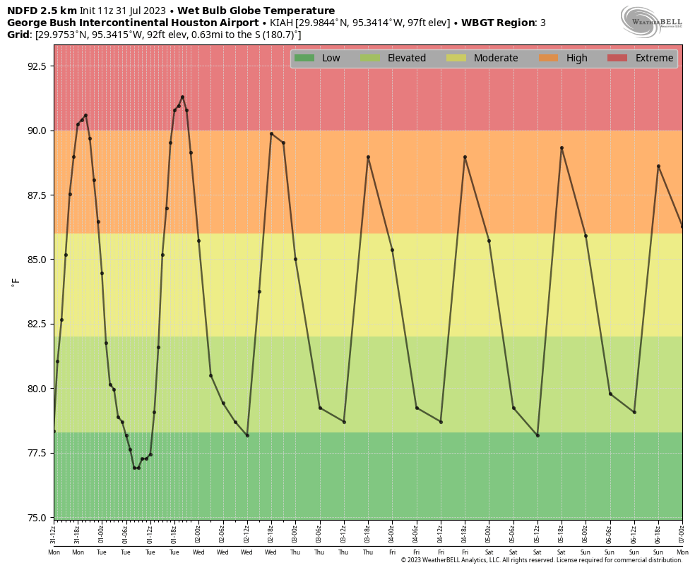
The story of our weather this week, however, is going to sound very similar. We’re under a potent ridge of high pressure that will consistently push high temperatures for areas inland of Interstate 10 to 100 degrees or higher this week. Monday and Tuesday look to bring the hottest weather, with afternoon temperatures and humidity combining to push heat conditions into the “extreme” level based on wet bulb globe temperatures, which factor in raw temperatures, dewpoints, wind, and other factors to provide a sense of heating. Those winds, by the way, will be light, at just 5 to 10 mph from the southwest.
Wednesday, Thursday, and Friday
Big-time heat continues this week, with highs of around 100 degrees, and lows around 80 degrees, and plenty of humidity. Rain chances, as mentioned in the post’s introduction, will be on the order of 5 to 10 percent.
Saturday and Sunday
Toward the end of this week the high pressure system will slowly start to retreat westward, and that will have some subtle effects on our weather this weekend. First of all, temperatures may come down a degree or two. Still very hot, but not excessively so. And perhaps we will see some more clouds, with rain chances rising to about 20 percent each day. Let’s not kid ourselves, though. For the most part these look to be very hot and sunny days.
Next week
I’m going to ballpark highs next week in the upper 90s, with a daily 30 percent chance of rain, give or take. So again, the takeaway this morning is that this week looks extremely hot; next week a bit less so, and I would urge you to hang in there. This can’t last forever. And it won’t. Even if it seems like it will.


lol 😂😆 I wish I could post these.
Sometimes I screenshot them and post.
I have a few frens here in H-Town 🥰 tysm
lol 😂😆 I’m old and I figured out how to post it. But I love them anyway 🎉
Great wether analysis AND a sense of humor- Love this site!!
Not making friends with clickbait like this. And then to say “yes” and still it was a no. So disappointing.
Lighten up Rosi.
😂
It isn’t clickbait if you had already clicked on the story and were reading it.
I just love philosophical meteorology! Y’all are terrific!
This is the type of Summer that is probably not going to truly lighten up until mid September give or take a week or two. I think we will finally start seeing widespread soaking rains and cooler temperatures return by this point when that stubborn upper level ridge finally breaks down. We may be in for a pretty wet October given the building El Nino. We tend to see upper level troughs stall out over Texas during El Nino Octobers which can bring alot of rain to our area. However, trying to predict the weather weeks or months in the future is like trying to predict the stock market. I will happily admit now that I could be completely wrong with my prediction.
I like your assessment. Sounds logical given the tendencies during an El Niño.
The only saving grace that we have not suffered 105 to 110° actual temperatures is that we did not enter this summer into a drought.
Looks that way, we’re just going to have to suck it up for about six or seven more weeks, unless the death ridge moves away just far enough to let a Hurricane in, how convenient.
Hey all, I’m ready for that October rain. What’s the word on the white oaks. Mine seem ok. A few small areas got sunburn. But reading on ND that people are “deep watering”.
It’s good to see you Houston meteorological buffs offering the whole regional weather story and upper-air forecast data especially about the summer dominating 500mb subtropical high (furnace) pressure dome around Texas to readers here, with the “possibility” of a little rain next week around there.
In my 20 years of weather analysis just down the road living in South Texas, since El Niño has finally and officially come back now (according to CPC), it has typically played a bigger role in the power of the usually dominating summer high (furnace) pressure dome aloft as opposed to La Niña, in past years. Particularly that 500mb feature that tends to suppress almost literally any kind of convection around here. Although there was some activity going on onshore around the Brownsville region last Friday.
Late August is normally the latest that subtropical Pacific high begins to actually lose its grip here at least on the Texas coast, giving way to those typically heavy-duty September rains that rarely fail around here in any given year. I’m personally not concerned about a Texas coast hurricane strike this year in 2023 given climatological history on the upper-level pattern in strengthening El Niño summer-fall years (such as in 2009 and 2015). But, given the current situation with the ever-so dominating subtropical high aloft around Texas right now, I’m not surprised the main global models (GFS and ECM) have been pushing back more and more on the longer range higher rainfall predictions for August, lately.
What pattern prevents this insane heat and drought in summer? 2011 was La Nina, 2023 is El Nino. Is neutral phase the best for us to have wet summers?
Nice to see a fellow thunder lover, as I love thunderstorms the most too.
Despite 2011 being a La Niña year, that was a definite exception as there hasn’t been a La Niña summer that dry around here since then. They’re typically wetter and “cooler” overall with more tropical activity in the Gulf/Atlantic. Major TX hurricanes like Harvey back in 2017 and Ike back in 2008 came during La Niña or Cool neutral phase summers. The only strike in recent decades during a warm neutral phase was Claudette back in 2003. Which was only a category 1 at landfall.
I’ve noticed that neutral or weaker (or weakening) EN/LA phases do generally make things more active around here throughout the year. Particularly around the middle of the decade. But that could be because of the MJO phase as it also tends to affect rainfall a good amount. More so during the later fall-early spring time.
I should also mention major hurricane Bret back in 1999. Which came in a 100% official La Niña year.
Did you forget last year? in west Houston we didnt get a drop of rain for the entire summer until September and it was a La Niña… 2021 was also pretty dry. I think the tendency is now that this side of Texas is starting to have more desert like weather. Hotter, drier summers and extremely cold snaps of winter. The desert is moving east… too much farming and yes HUGE silent deforestation taking place all around this side of the state.
Your report could be much simpler and shorter:
Monday: Same
Tuesday: Same
Wednesday: Same
Thursday: Same
Friday: Same
…
Better to have substance to these posts or else people complain
Thanks…..James.
Am I the only one eating bugs to change the weather? Because it’s pretty hot these days, but I’m really missing burgers and steak.
I liked to eat chapulines years ago before they saved the planet. Go ahead and light up your grill and throw on some hamburgers.
“Unfortunately that light is the sun”?!?! I laughed out loud and then called you bad names that I won’t repeat. Way to emotionally manipulate your readers! Seriously, I laughed so hard, you %#*<>£¥€. (6 weeks is hope at this point.)
The worst part is, when we go on our nightly walk–this is starting at around 8:15PM–it is still in the 90s. I don’t ever recall such high temperatures at night.
this is true not even in the 70s when we has all these heat waves did it ever feel this hot at night
It is not good to have less daylight because I need to come home and work in the yard and work on cars and bikes and stuff.
Will be so glad when November gets here and I can finally go outside after 8 months of not leaving the house.
With this constant heat and lack of rain we’re getting real close to the “forget the grass and water only trees and your foundation” portion of the drought.
That’s where I am these days. Grass is a crispy brown; I’ll give it about 1/2″ of water a week to keep the roots from dying. Trees are watered. I’m going to start planting more central-Texas native flora so they are more drought resistant.
Kinda bad when it takes something like the Sharan desert to cool things down.
Just curious, why isn’t Wet Bulb Globe Temperature more widely used (takes into account temperature, wind speed, humidity, cloud cover/sun…)?
https://www.weather.gov/tsa/wbgt Even weather.gov has it as experimental!
Six weeks until a front. Now there’s something to look forward to! Houston’s second Spring.
Good news…this is officially the LAST day of the July 2023 Heat Wave.
Bad news…tomorrow is officially the START of the August 2023 Heat Wave.
Yes, time to start deciding which small trees to water deeply and save. Forget the brown grass….pretty hopeless cause. I liked the half inch per week watering suggestion by Scott to at least save the lawn’s roots. About the Title: Ha ha, the light at the end of the tunnel is the sun. Clever. But all we are left wondering is…..how long is the tunnel? Thank you Space City for suffering with us. We know you care. 🏆😎⭐️🥇from David in Central Houston
Relief should come in late October. Just don’t ask which year.
This is one of the funniest posts ever. Well done.