Good morning. Today is Juneteenth, a relatively new federal holiday that has its origins in Texas. Juneteenth is celebrated on the anniversary of Major General Gordon Granger arriving in Galveston and proclaiming freedom for enslaved people in Texas on June 19, 1865. This came two and a half years after the Emancipation Proclamation was issued.
Unfortunately, we will not have freedom from extreme heat today. Some very moderate relief will arrive later this week, as well as a slight chance for our first showers and thunderstorms in awhile. But it will probably be fleeting.
Monday, Tuesday, and Wednesday
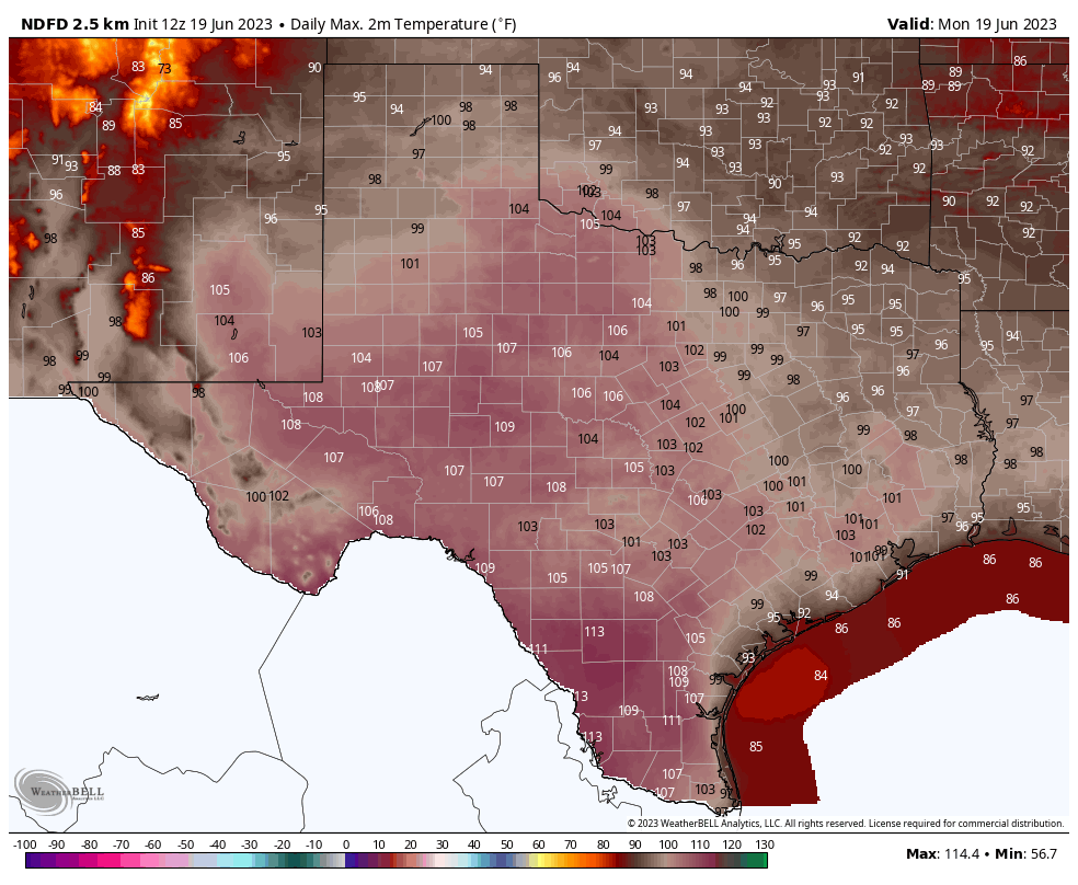
For the first two or three days this week we are going to see conditions very much like what the region experienced over the weekend. That is to say, high temperatures of about 100 to the low-100 degrees with high humidity, leading to an extremely elevated heat index. An excessive heat warning is in effect for now through Tuesday, and we can probably expect that to continue through Wednesday. Please continue to take heat safety precautions when outdoors during the middle of the day.
Thursday and Friday
Sometime on Wednesday, the high pressure system that has dominated our weather for several days will begin retreating slightly to the west, allowing for a cloudier and slightly cooler period. The relief will be modest, with high temperatures likely in the mid- to upper-90s, but it should bring down the dangerous heat index for a few days. Some weak disturbances will also drive rain chances into the area for a couple of days. Do not expect much—most areas probably have a 10 to 30 percent chance of rain—but this is better than what we’ve seen for a week now.
Next weekend and beyond
The medium-term looks pretty hot, I’m afraid. At this point the most likely scenario is that the high pressure system starts to rebuild over Texas, including the Houston metro area. So we probably will see the return of triple digit temperatures, sultry humidity, and heat warnings. I wish it were otherwise.
Tropics
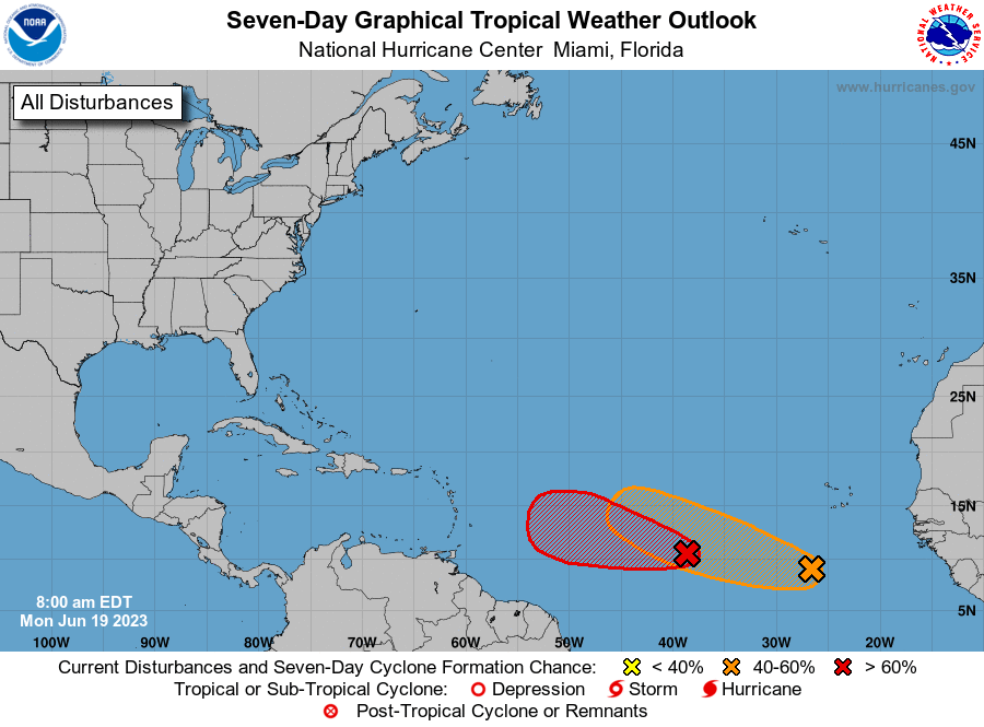
The Atlantic tropics are unusually frisky for this time of year, and we can probably expect the formation of Tropical Storm Bret within the next day or two. The storm, and an additional wave behind it, likely are of no consequence to Texas or the Gulf of Mexico. For full coverage of all things tropics, be sure and check out our new Atlantic hurricanes website, The Eyewall.


Atlantic map caption: mid-June, not July
It looks like a repeat of last summer with the death ridge living in South Texas for 4 months. Is this a new normal for the area? Where summer’s resemble south Egypt rather than south Florida? Sure seems that way.
Forgive me for not editing my own comment a little better using summers in possessive form rather than plural.
Oh that silly apostrophe, so few people know what to do with it. 😉
👍🏻
Up in College Station, our weather people are saying that-like last year-now that the heat dome is here-we are in for hotter and drier than “usual” weather for the rest of the summer. Hype or valid assessment?
Thank you for being brutally honest about this heat. I’m sad it looks like it’s shaping up to be such a dry summer. This heat is offensive LOL!
I was hope the end of La Nina and the rise of El Nino meant less heat and more rain chances – some news stories were predicting that anyway. It isn’t happening so far at least.
The effects of El Nino usually don’t come into play until the Fall and Winter here in Southeast Texas. Both the subtropical jet stream and the polar jet stream buckles and shifts further toward the south during El Nino winters. This causes more frequent rains and colder than usual temperatures to persist over Texas during the Winter. However this is not a guarantee because like DJ said, ocean temperatures off the coast of California also influence the jet stream in other ways. Ocean temps off the Pacific Northwest can also have diffrent effects on weather patterns. Ironically enough El Nino can actually contribute to droughts in Texas by cause high windshear in the gulf of Mexico which prevent tropical systems from organizing which can keep us stuck under High Pressure even longer. So the very same thing that is keeping us hot and dry this summer may bring us prolonged cold and rain this winter. The weather works in funny ways like that.
It’s just so unbearably hot outside right now. My glasses and windows fog up because the dew point is so high. In fact, the dew point here is about as bad as it gets world wide. I think the Persian gulf gets worse sometimes and that’s about it.
The Pacific sea surface temperatures off the coast of Cali are still anomalously cold. I think we don’t have the set-up yet that would negate the mid level heat impact of the high Mexican desert in these parts. Experts please weigh in. So SE Texas remains “capped” and moisture can’t rise and condense. If you go just 300 miles east on the GC, that effect is gone. Much more variable and pleasant summer weather there. Barring storms from the GOM, this then is the summer pattern for us. As they say “we’ll see”.
Why are 92L and 93L likely of no consequence to Texas? Eyewall says a weak 92L moves toward Caribbean, and a weak 93L also probably moves toward the islands.
Yuck bucket is right on 👍🏻
Any ideas on why would the high pressure system loosen, then retighten again? Isn’t that kind of unusual?
Ty for your awesome work! 🌬⚘
It’s actually not unusual at all. Often times the upper level high pressure ridge will shift away briefly during the summer and then return bigger and stronger than before in a few days. However it is unusual to see heat indexes over 112+ especially in mid June. I think it has to do with warmer than normal water temperatures in the gulf plus the winds have been blowing out of the gulf stonger than normal which also pumps more of that tropical humidity in the air.
Thanks ☺️
Stay cool! 🌬❄🌊❄
Good time to start getting the hurricane supplies together!
Everyone is saying that now the summer will be hotter and drier than normal, like last summer, however, last year, the hot and dry weather started much earlier, April was unusually dry, and it continued the rest of the spring and summer. This year, there was a much cooler and wetter start to spring and summer.
RAIN! when are we having rain????
Does El Nino have anything to do with this yet?
Also El Nino defined when the water temperatures in the Equatorial regions of the Pacific are warmer than usual not the entire Pacific Ocean. Same with La Nina as well. Just to clear some confusion about that.
Yessir Joseph. And we’re not seeing that. Are we. The entirety of the tropical Pacific SSTs remain anomalously warm all the way to Australia and the waters off Cali are cold. This then is NOT El Niño (but not La Niña either) and the news stories about El Niño have “jumped the gun”. So same old, same old for SE Texas for now is my un-expert take. Good luck growing things again this year. We’ll see…
Thank you it was a pain trying to grow vegetables last year. We were having good luck so far this year because of the spring rains but after 3 weeks of no rain it’s going to be a struggle again lol
Love the name, The Eyewall! You guys are so entertaining and smart
Great report, as usual, but getting down to the important and real nitty-gritty stuff, should Katy evacuate now or a few days from now, and stay self-evacuated until late October or so?