Good morning. Heat remains the dominant storyline of our forecast for the remainder of August, and conditions look to be especially warm from now through the weekend. However, I’m watching for a chance of showers this afternoon and early evening, and for some potential changes in the forecast next week. Also, we’ll discuss a tropical blob in the Caribbean Sea that’s expected to move into the Eastern Gulf of Mexico early next week.
Thursday
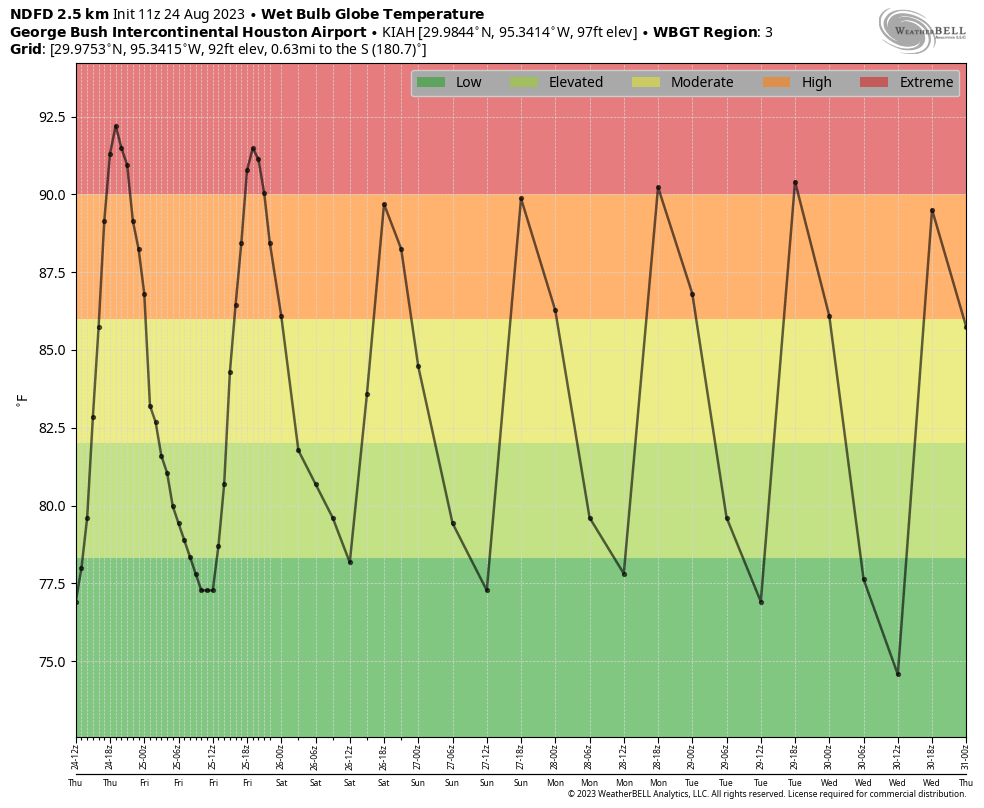
Today is simply going to be blazing hot. Highs will range from near 100 degrees right along the coast to around 105 degrees or higher for inland locations such as Spring, College Station, and Kingwood. Skies will be sunny. With that said, some of our high-resolution modeling is indicating the possibility of an atmospheric disturbance moving southward later today, and this could produce scattered showers from mid-afternoon through the evening hours. I will freely admit that this forecast could be a total bust, especially with high pressure in place. But I think there’s at least some hope for a pleasant surprise with scattered showers this afternoon.
Friday
Another hot day, but temperatures should be a couple of degrees cooler than Thursday. We’ll again see sunny skies, but there’s also the possibility of a few late afternoon showers.
Saturday and Sunday
No changes in terms of temperatures. We’re looking at highs, generally, in the low 100s. Saturday is going to be sunny and hot. Sunday will as well, but at least there appears to be a slight possibility of some rain showers.
Next week
By early next week the dominant high pressure system will be retreating westward, and that at least opens up the possibility of some changes in our forecast. What form, precisely, those will take is yet unclear. At this point I’d guess highs will still be about 100 degrees, but we’ll see some daytime rain chances—whether those are 20 percent or 50 percent, I cannot say. There’s also a slight chance that a weak front pushes down into the region on Tuesday, which could knock humidity levels down a bit. But that is all very tentative. Our weather may also be influenced by a tropical system moving into the Eastern Gulf of Mexico.
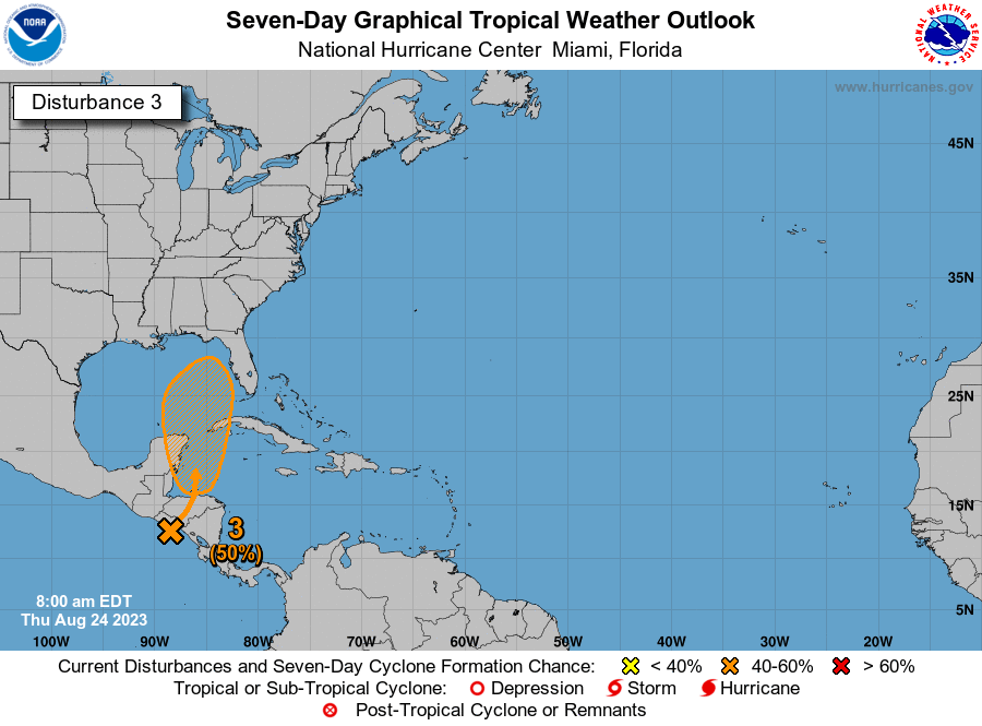
The tropics
For a few days now, the European model has been suggesting that a tropical system will emerge in the Western Caribbean Sea, related to the Central American Gyre, which is basically a broad monsoonal low-pressure system over Central America. Under this scenario a tropical low would then move north, into the Eastern Gulf of Mexico. Note there is far from universal support for this idea in the global models. In any case, such a system would likely remain away from Texas, and push drier air into our region from the northeast. For more detail on this system, check out our Atlantic hurricane coverage on The Eyewall.


Rain?…. Yeah, right. Believe it when I see it.
In short, the weather will be continued disgusting for as far as we can see.
“Hope is patience with the lamp lit,” – Tertullian
There is only 30 days left until the vernal equinox, we are losing daylight daily. Take it from Mr. Tertuallian and be patient. Fall is coming!
Oh for goodness sake…we can’t catch a break. Another tropical system teasing us.
It’s too hot! I’m unsubscribing!!!!
😉
I’m thinking of creating our own summer “groundhog day”, maybe Cicada Day to see how many weeks we have left of summer. If the cicada screams, as they usually do, another 5 weeks. LOL
Fun idea Rinkos,
But if all the cicadas die from excessive heat and drought, then we will need a backup animal or insect. Maybe lizards? But they come out no matter what the weather. And they don’t make much noise. Happy Cicada Day! LOL
I got 10 bucks that says this August ends up as our hottest August (and month) ever. 2011 averaged 90.2F. Month to date is showing 91.5F.
Current drought monitor released today has awful but not unexpected news – all of the Houston area is at least D3 Extreme drought, with points east/northeast of Harris county as D4 Exceptional drought, the worst category. Next year we’ll need to replant our dead plants with more drought resistant central Texas native plants.
Scott, the record is pretty much in the bag. Don’t think that you will find many takers on the 10 bucks!
Eric. I know you too have been puzzled with temps reported on iPhone weather. My watch says 105 degrees. I’m two miles west of 610 on San Felipe and my thermometer says 101. 4pm today
IAH is currently sitting at its all time record of 109 at 4pm
IAH just SPIKED from 103 to 109 from 2:53 to 3:53 PM. If that’s not startling to you then neither is an Amber Alert probably.
Absolutely pouring on the west side of George Bush park.
Yep! I won the rain lottery big time tonight! I’m near Eldridge and Briar Forest. I checked the radar and we had an honest to goodness thunderstorm and lots of rain. I was so happy because the Palm trees have started to die. The temperature dropped from 104 to 78 in an hour!
Power’s out. What is it with severe thunderstorms and this summer?
Probably just because a very hot humid atmosphere creates very strong instability in the atmosphere and all it takes is a spark like the sea breeze, outflow boundary or a cool front for powerful storms to fire up. We’ve had a intensely hot humid atmosphere this summer so any triggering mechanism just creates a nuke of a storm. I’m sorry about your power outage hopefully it comes back on soon.