Good morning. Before jumping into the forecast I want to briefly touch on Tuesday’s rainfall, as well as our brief reprieve from extremely hot weather. First, the rainfall. Parts of Galveston and Brazoria counties received a few tenths of an inch of rain from fading Tropical Storm Harold on Tuesday. These were welcome, if brief downpours of tropical rains. The vast majority of the region along and north of Interstate 10, however, received no precipitation whatsoever. The bottom line is that, as expected, our ugly and worsening drought continues. See the end of this post for a discussion of rain chances down the line.
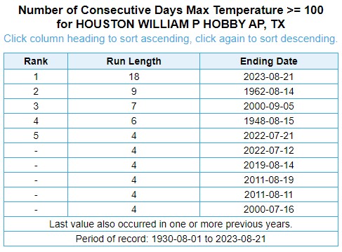
Additionally, the cloudy skies and breezy conditions—the strong easterly winds were part of Harold’s circulation—helped keep a lid on high temperatures. Houston’s Hobby Airport topped out at 97 degrees, and Bush Intercontinental peaked at 97 degrees as well. Both of these locations ended long streaks of days with recordings of 100 degrees or higher. Hobby’s streak was remarkable, 18 days, doubling its previous record of nine days. Hobby has collected meteorological data for nearly a century. Bush IAH ended its streak at 23 days, falling one day short of the city’s all-time record of 24 days, set during the torrid month of August 2011.
Unfortunately, we’re probably going to start new streaks at both locations today. Harold is gone, and extreme heat is back on the menu for a little while longer.
Wednesday
We’re right back to very hot weather today, with area-wide highs of about 100 degrees, high humidity, and mostly sunny skies. Winds will shift to come from the southeast at 5 to 10 mph. The key difference for the rest of this week is that we are going to see some weak atmospheric disturbances roll through the area. It’s going to be difficult for these to generate significant rainfall, given the sinking air associated with high pressure. However, it will not be impossible, and therefore each day should carry about a 20 percent chance of rain.
Thursday
As high pressure moves almost directly overhead, this should be a very hot day, with highs generally in the low 100s across the area, away from the coast. Afternoon rain chances, again, look to be on the order of 20 percent.
Friday, Saturday, and Sunday
The forecast remains more or less the same, with highs of around 100 degrees, mostly sunny skies, and a puncher’s chance of some rain showers.
Next week
This is where the forecast starts to get a little bit more interesting. The high pressure system that has dominated our weather for much of this summer looks to fade westward, and this should allow for a slight moderation of temperatures. We may also see some better rain chances by Tuesday or so of next week, but that’s far enough into the future I would not want to bet on anything. But I do have some modest hopes, and the end of August is on the horizon.
Space City Weather app
We’ve updated our app to address some bugs that readers have reported with old timestamps and odd temperatures. Our developer thinks he has worked through the problem, but if you’re still seeing issues, please email us at [email protected]. Thank you to everyone who reported problems in the last couple of weeks. If you haven’t downloaded our app, you can get it for free here for Apple, and here for Android.


Cannot thank you enough for all you do and how you go about it. I’ve shared your posts here, as well as The Eyewall, with family in the Los Angeles area, those in Baton Rouge, and anywhere else where I think your message would be beneficial.
For 7-10 days out, the pattern in my weather app of choice (Wunderground) and in some of the weather vendors we use at my job (Earthsat or whatever they’re calling themselves these days) has been one of relief in the form of more seasonal temperatures, which then proves to be a mirage in the desert when we get a little closer. What is your confidence this time around? Will we actually see moderation of temperatures?
In the 7-10 day window, could it be that a lot of models are reverting to a mean that is just too low?
Imagine a high of 95, and calling it relief!! Love my summers, but this one has been brutal.
At this point I can’t get my hopes up about the high pressure dome moving westward until I actually see it happen.
Eric, did you have to do the post today because Matt is inconsolable over not continuing the 100-degree-day streak?
I getting a bit pessimistic regarding the “next week” possibility….. been hearing “next week” fairly regularly.
Agreed – might be my age, but it seems I keep reading, “the high will move off to the west next week”. But it’s well known, no one has influence over the weather. And predictions are only guesswork 🙂
Not hitting 100 yesterday was like a batter bunting to break up a no-hitter. Valid, but we all know what’s really happening. “Asterisked” streak.
Hard to believe that 2 years ago we didn’t see one triple digit day. Now this year we are giving the summer of 2011 a run for its money. This is insane because while the drought this year is bad, it isn’t near as bad as it was in 2011 at this time.
2011 is still the champion , because if you recall back then from Oct 2010 to Dec 2011 over 400 days, we didn’t receive any rainfall save for a few days here and there. Think about that, no rain for over a year.
This summer will get a shiny silver medal though and take its place in the Mount Rushmore of miserable summers.
Patrick, can you not ‘get over’ 2011, are you joined to the hip or somehting? It is time to move on.
Ken.
Its the standard that all other recent summers are measured by.
You’re probably right, that summer sucked do bad I’m scarred. Maybe I need some couch time with the weather shrink.
In terms of drought, yes. In terms of hottest August on record, no. This month looks end up hotter.
Sorry: looks to end up hotter
Yes you are correct. The Summer of 2011 definitely still holds the golden metal as far as drought is concerned. The majority of Texas was in D4 drought for over 8 months that year. It started during the fall of 2010 likely linked to the La Nina that developed that year. It was an apocalyptic scene for sure. Unfortunately I am seeing very similar scenes in my area right now. I have seen an alarming amount of dead and dying trees here in western Brazoria County within the past few weeks. There are 4 more dead trees in Sweeny that I noticed today that were still alive a couple of weeks ago. It is truly frightening how this summer has taken this big of a toll on our trees considering the cool wet spring we had.
I got an entire 0.03″ of rain yesterday! This storm would have been great for us here, but the RGV needed it too, just hoping that the linemen are Johnny-on-the-spot for all the residents down there because their temps quickly returned to HOT and any power loss would be felt more with this heat.
I was amused all day yesterday when I remembered how the forecast began, “Damn it, Harold!”
Yesterday there was a trace of rain maybe a couple dozen large drops at Reveille St. and Sims Bayou, at the North Freeway and FM 1960 and a block and a half west of Lake Conroe.
The big question for me is whether this summer is an outlier or consistent with what future weather patterns will be like? If this is what a normal summer looks like moving forward, I’ll be leaving. If I have to choose between being cooped up for 4 months due to cold or heat, I’ll choose the cold.
Weather preference are very subjective and I am a weirdo. I love cool/cold, wet and dreary. This constant heat and sun has made me unbelievably sluggish and more than a little cranky. I’m jealous of the people who love the constant sun and heat.
That would be absolutely horrible. I am wondering why people/scientists seem to think climate change will cause longer periods without rain. How exactly does that work?
It has to do with the jet stream. When the poles warm and the temperature difference between the poles and equator is not as extreme, the jet stream tends to wander and meander rather than drive weather systems from west to east across the mid-latitudes. That’s how we get storms like Harvey sitting on us for 6 days, or a high pressure sitting over us for 6 weeks. The jet stream is not as strong and tends to get hung up. That can cause more flooding, longer periods of heat, longer periods of cold.
So what is the jet stream doing (or not doing) this summer? Or is it just too far north?
It’s a very sad day when I get excited that the weekly forecast dropped the 104F highs to “only” 101-103F. The only plants left in the garden are my battle hardened and super heat loving okra. And even these guys wilted and had leaf burn on Sunday! They’re native to tropical Africa so no stranger to 100F. But 106F I think is there limit. I feel like an okra plant sometimes. Lol
Why does the SCW app show a thunderstorm icon for every day from now until Tuesday if the chance of rain is near zero?
Its not near zero, its 20%.
“Hope is important because it can make the present moment less difficult to bear. If we believe that tomorrow will be better, we can bear a hardship today.” — Thich Nhat Hanh
In todays semi-daily dose of hope from Glenn we go back to the dreaded heatwave of 2011. The last 100 degree day that year come on September, 14th.
Which if history is our guide we have no more than three weeks left to endure…
I seem to recall that we got a nice cool front on or around Labor Day in 2011, that dropped low temps back into the 60s for a few days (before the heat returned for a bit). Felt great after that miserable August.
Here’s hoping we get some real relief from the heat and drought soon!
Yes you are correct. We had a solid cool front that blew in on September 5th 2011 which brought us a couple of nights in the upper 50s. Sadly this same dry airmass also triggered the devestating Bastrop wildfires.
There’s a few models showing the remnant of Harold looping over through Central US through the Heat Dome. I’m guessing it’s not likely to happen, but if it does is that because the head dome is moving?
What happens to the weather in the case that they fight against each other? I think the heat dome wins out right and shifts the remnants to the west?
Thank you Gentlemen for always taking the time to give us the news. I appreciate it greatly.Rudy, Spring TX
Nassau Bay’s rainfall measured 0.16″ on Tuesday afternoon. Wanted to scoop it out of the street however knew the dragonflies, bees, wasps, squirrels, birds would relish it.