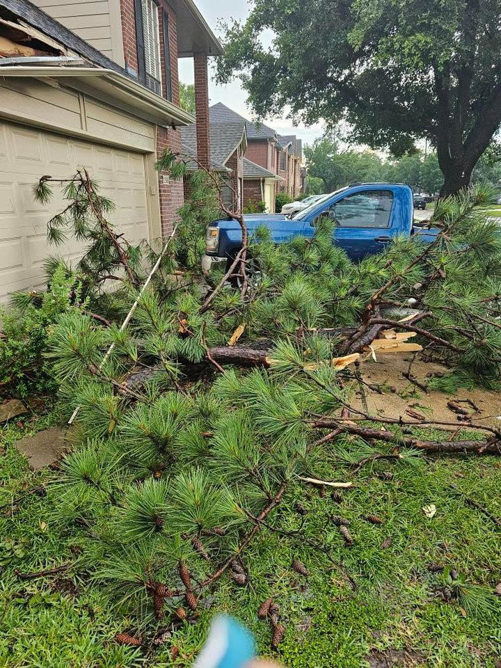
Hello on a Sunday, not because the forecast has changed (it’s going to be extremely hot the next 5 to 6 days, with excessive heat warnings in place again), but because I think folks deserve an explanation about this month. Our forecasts have not necessarily been horrible or anything, but we have all been caught by surprise at the ferocity of some of the storms in June. Many of you have lost power at one point or another, some for days, while others have sustained property damage from winds or hail. So, why?
The National Weather Service forecast office in Houston has issued 47 severe thunderstorm warnings this month across the region. There have been a total of 159 wind or hail reports from across the region.
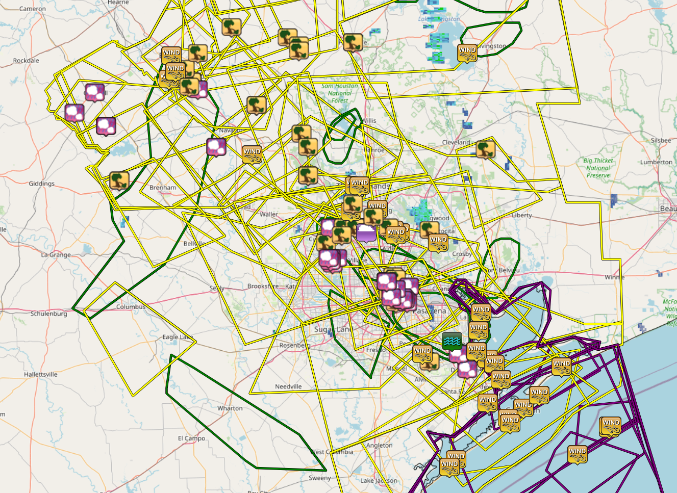
The actual number of damage reports is certainly much higher, as some were surely consolidated or others were not submitted to the NWS office. Whatever the case, it’s been a lot. The only portions of our area mostly spared some element of significant severe weather have been in Fort Bend and Wharton Counties through Lake Jackson and Matagorda Bay.
Let’s quickly recap a few of these events.
June 4th
We were delivered an early wake up call back on June 4th, when storms rolled through the metro area between Midnight and 2 AM or so.
Bush Airport reported a 62 mph wind gusts with these storms, and there were numerous reports of trees and powerlines down. These storms were not expected to hit so hard or quite so soon, so this one caught us a little off-guard. The 3rd was a relatively pleasant day with comfortable dewpoints and highs in the mid-90s (which sounds wonderful given where we are today). But with a weak upper low over Texas, that’s all we really needed to generate storms, and they just managed to survive the trip. Upper lows are notoriously fickle, and as such, we got burned.
June 8th
Wind and hail ripped across the area on the evening of June 8th. This event was better telegraphed than some others this month. We mentioned a good chance for storms and underscored the uncertainty around the storm evolution. So this one didn’t catch us off-guard. But it still ended up pretty vigorous.
Both IAH and Hobby gusted to around 45 mph with these storms, while just off of Texas City recorded a 67 mph gust. Centerpoint had something in the vicinity of 175,000 outages I believe. Hail reports were several, and rain totals of 2 to 3 inches southeast of Downtown Houston produced flash flooding.
June 10th
The storms on Saturday the 10th were also somewhat well telegraphed, as we were outlooked for severe weather and we noted the chance in our posts. The City of Houston was mostly fine in this one, but areas north and east and well northwest of the metro area saw some significant storm reports. Bush officially gusted to 58 mph, while Hobby hit 53 mph. Multiple 60 mph wind gusts occurred in the bays and off Galveston, while hail of golf ball size was reported in Burleson County.
June 21st
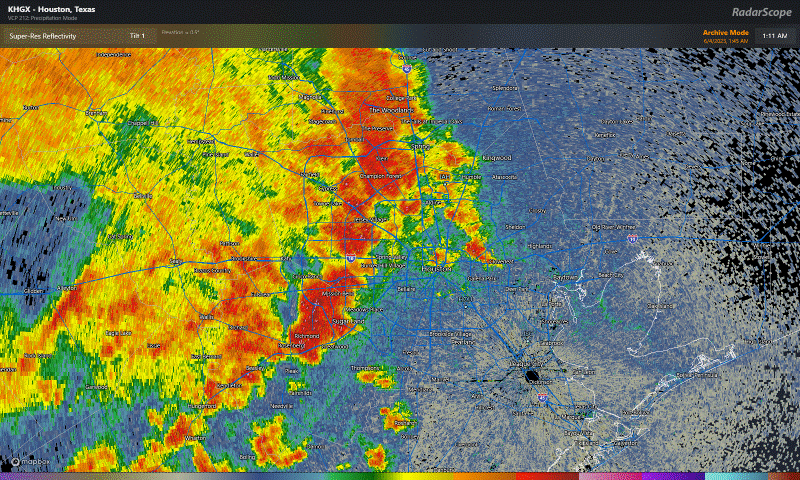
This past Wednesday’s storms were utterly ferocious.
Bush Airport’s 97 mph gust toppled Hurricane Ike from the top of the leaderboard there, with numerous other locations seeing 50 to 80 mph wind gusts, knocking out power to hundreds of thousands, some of whom remain in the dark as of this morning.
These storms were poorly forecast. We did talk up rain chances for Thursday, but in reality these came roaring in a good 12 hours faster than anticipated on Wednesday evening, and obviously with more rage than we predicted too. We can look to Friday for further evidence of this as well.
June 23rd
The latest round of violent storms struck on Friday evening with hail and wind. Hail to the size of golf balls and hen eggs fell south and east of downtown Houston and on the west side of the city in two pretty distinct belts.
What happened this past week?
So, what exactly was at play this week, and why did we miss the mark on the forecast?
Often times in summer, high pressure tends to “anchor” in one part of the country or another. This month, we’ve seen it anchor mostly over South Texas and Mexico.
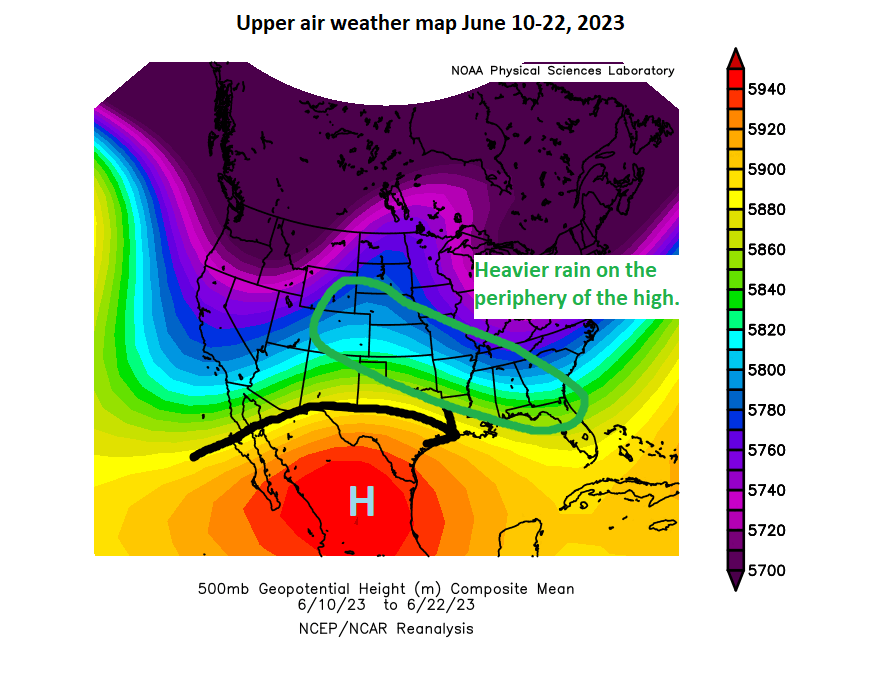
Storms have generally driven the periphery of the ridge, which has led to high precipitation over the last couple weeks from Colorado into the southern Plains and Southeast.
There were a couple changes this past week. The high reoriented closer to Big Bend (which allowed some all-time record temps to fall in South Texas), but it also shifted our flow to more northwesterly or northerly.
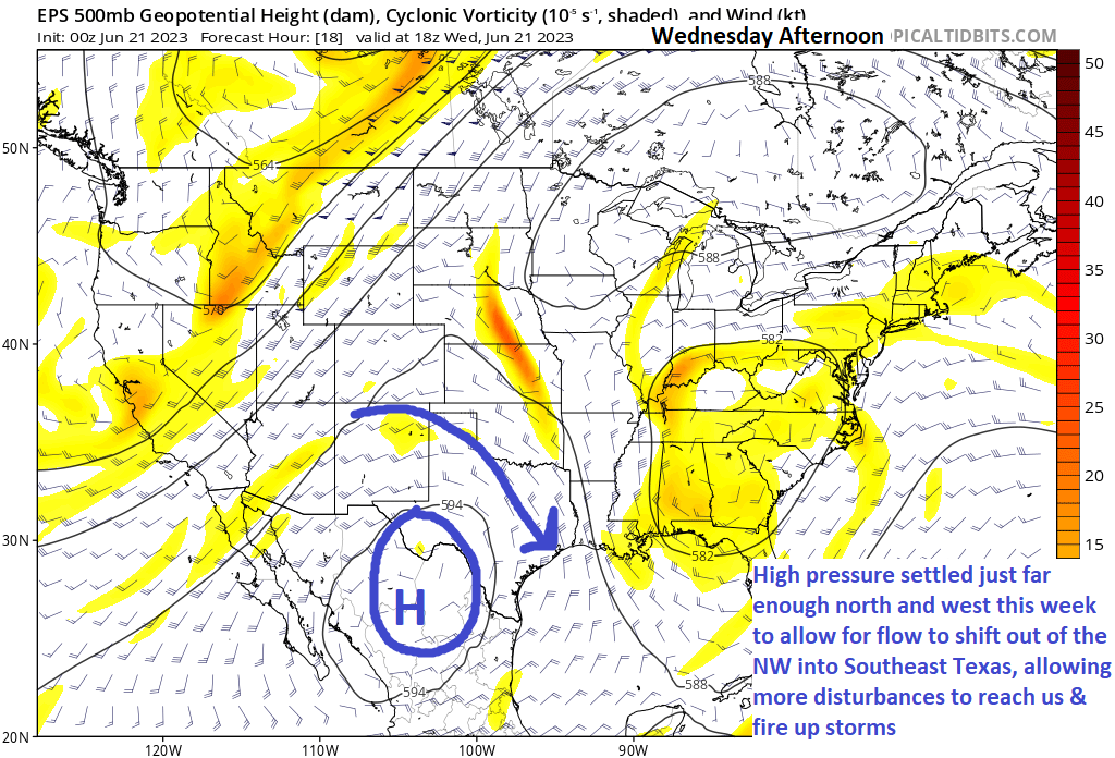
Why is this important? A couple reasons. Being along the periphery of the high allows for the best combination of daytime heating and instability, as well as being “in the way” of quick moving disturbances. The amount of instability that developed on Wednesday afternoon in particular was extremely high, some of the highest we usually get around here. We just needed a spark, and we got it. We thought the disturbance was targeting more like late Wednesday night or Thursday morning, which would have resulted in storms but perhaps not high-end severe storms. Instead, it coincided with peak instability on Wednesday evening, and alas we got walloped.
On Friday, we expected some storms to the east. That happened in the morning and afternoon. But with lingering boundaries and a little spark from a nearby upper disturbance, we were able to just keep building storms again and again as they migrated around the periphery of the developing high pressure over Texas — until it just ran into dry air and fizzled southeast of College Station.
So Wednesday’s storms were more driven by a strong disturbance coinciding with peak heating. Friday’s storms were more mesoscale in nature (smaller scale things like wind boundaries helped buoy them). Both events were enhanced by extreme levels of instability provided by heat and humidity. Wednesday’s storms brought significant wind because they were 60,000 feet in height and collapsed, bringing all the wind down with them. Friday’s storms brought more hail issues than wind issues because the storms were 60,000 feet in height and continually redeveloping. Updraft after updraft allowed for large hail to form. Different drivers and different reasons for the outcomes we experienced.
In general, predicting these types of storms is kind of a roll of the dice. Disturbances “ride the ridge” at different speeds, which are occasionally out of sync with your forecast. And localized effects can lead to more substantial outcomes. Unfortunately on Wednesday, the storm began collapsing just as it approached the densely populated northern half of the metro area. And on Friday, the storms peaked in height & intensity right over the city. We still struggle at times with these types of events, but we learn from them to hopefully help next time.
Hopefully this is a useful explanation! We’ll be back with you as normal Monday morning.


Having been caught out in 97 mph wind gusts and deluge on Wednesday night, with visibility 8-10 feet,
I am surprised I made it home at all coming from Bush IAH!
Friday night was intense. Lindale looked like a war zone yesterday morning. Pure insanity!
Wed night was bad for us in Pearland/Manvel. My elderly labrador was so concerned he somehow jumped into the tub of the guest bathroom to hide (good choice – small room in centermost part of house). I didn’t know he could move like that at 13 years of age.
Very helpful explanation. I was just wondering about this topic this morning.
As above thanks for the background. It is very helpful. I had a flight instructor who told me “There can be no facts in a forecast. All you can do is not be surprised when the facts emerge and learn from them.” Your comments did exactly that. Thanks.
I really appreciated this explanation. We are on vacation not in the area and loved having your daily notes to let us know what was going on back home. The fact that you were close on many of these classes just shows how good you guys are at what you do.
Thomas Geehan thanks for the explanation, am now a more informed peon into why the weather is behaving in above average manner,
This is really good information, Matt. Thank you for consolidating it and helping to tie it together. Much appreciated!
☺️🌻☺️
Both you and Eric are awesome. Thank you for the info and for everything you do. Y’all help me keep calm while others feed the anxiety.
SPACE CITY WEATHER, y’all ROCK!
Can you kindly let me know if you know anyone in Northeast Florida that does weather reports like you guys? We so enjoyed getting your daily updates when we lived in Houston.
Google it!
Appreciate this post! Instead of moving on and letting it fade, you faced it and explained it. Very tough to do, meteorology is not for the weak anyway. That is why I never pursued it, the math scared me…not the storms. ‘Tis why you two are so popular, you are awesome at what you do, even if you stutter step (we all do). It’s how you handle it. 😉
Thank you, Matt, for your in-depth commentary on these weather events.
an you provide the link to interactive “map showing all of the warnings and storm reports from the National Weather Service Houston office for the month of June in the Houston area. (Iowa State Mesonet, IEM)” Would like to be able to zoom in ….Thanks
Reflections like this are a terrific service. Thank you.
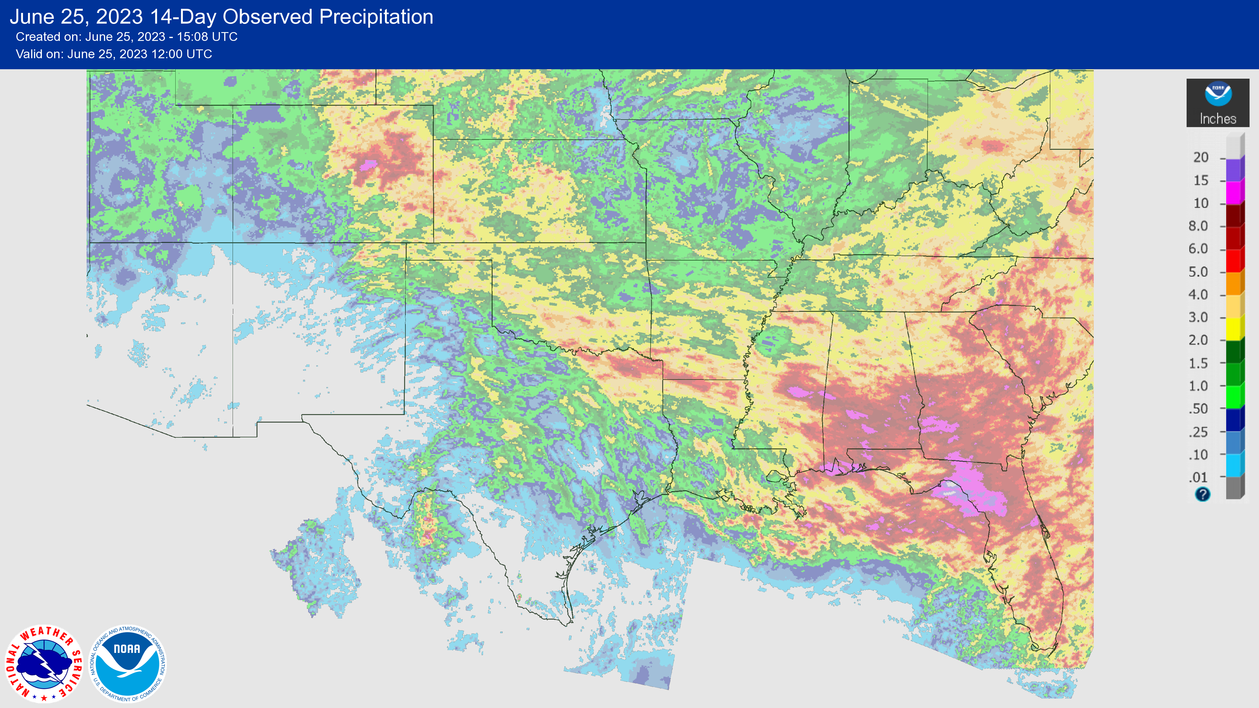
And the crazy thing is that all this has come with well below average precipitation. We got two storms a few days apart in the middle of the month with crazy wind but no rain.
Oh we in.
Spring did get 2″ of rain but it was the hard way
Great explanation. Exactly what I love about Space City Weather. As a person living in Spring and without power from Wednesday p m until Saturday p m it’s helpful to understand what occurred. Stay safe everyone