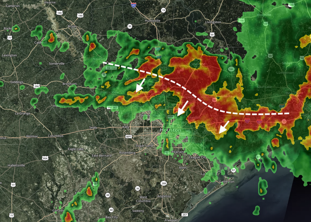
We’re continuing to track a very intense band of rainfall just north and east of Houston, which has been producing rainfall rates of 2 to 4 inches per hour. The National Weather Service has declared a Flash Flood Emergency until 11:15 am for Southeast Montgomery County, Northeast Harris County, and Liberty County. This is enough to quickly flood streets and back water up into yards (and over a long enough period of time, homes). This band is now slowly sagging into the Houston metro area, as seen on the radar image below.

We do not have a ton of confidence in the forecast other than this band should progress through most if not all of Harris County today, potentially bringing 2 to 8 inches of rainfall later this morning and afternoon. We do not know if it will strengthen further (unlikely), remain the same, or (hopefully) weaken as it progresses throughout the day. Needless to say it has the potential to disrupt any activities today, and we are likely to see flash flooding in the metro area as it moves through.
Meanwhile, the greater Beaumont region continues to experience a massive flooding situation as overnight rains devastated the area, and to some extent, are continuing this morning. The city has conducted hundreds of high-water rescues.

Kingwood now has enough rain. Thank you! Please make it stop now! :-).
Not funny Paul!
Not funny Paul!
Thanks guys! About what time frame do you think it will hit the metro area?
How fast is this moving, Eric?
I’ve got a flight out of IAH at 3pm today :/
You may not. Just heard that IAH is on full ground stop and roads are flooded. Be safe and reschedule your travel. You don’t want to be stranded.
Have you heard how long it will be closed? I have a flight on Saturday but I think/hope it’s supposed to be better than.
Wondering as well what time it would hit downtown and meyerland.
BOOOOOOOO
Finally rain in Cypress.
How did this set up?
Winds wrapping around the storm colliding with humid southerly winds off the gulf. This moisture is getting lifted into the cooler upper atmosphere creating the rain.
Come on, dude. People are suffering right now. Not funny.
How about Galveston County and Texas City? How much more rain? Thanks.
I live in the Beaumont area and this is deja vue. Went through this same stuff with Harvey. I know people who are already flooded. Makes me very nervous.
Just been told we are being sent home from work!
lucky duck, be careful getting home. We are on the west beltway and we have tons of ppl from all over. It’s been raining non stop here for an hour now.
We are at West Belt and 59 and trying to figure out what’s going on!
I love the Katy jokes, but there is a time and place. Now is neither the time nor the place.
This seems to have caught forecasters off guard. What happened??
Nature.
Re “off guard”, depends on what period you are speaking off. David Paul totally nailed this possibity in Futurecast during 10:00 newscast last night.
Agree that this has caught many off-guard. The predictions showed Imelda moving north by now, no? Announcing that today’s mess was a possibility at 10 p.m. last night does not serve anyone’s best interests. I look forward to Eric and Matt’s thorough review.
It seems like Imelda is headed back to the Gulf. If so, is it likely to strengthen and come back to us? Do the European models show anything?
Thanks, all, for getting us through.
Much appreciation for the updates.
[Wishing for the cold front.]
I used to live in Philadelphia and the news would always forecast x amount of snow and then the next day, they’d be like well this is what happened
11.41″ on my weather station here in Kingwood since 6:30AM Agreed…. enough!
The Galleria area looks like the apocalypse is coming.
All the people who were lined up begging for rain please report to the main lobby for your public lashings!
Lived in this house in Kingwood area 8 years, no flooding during Harvey or even during the May 7 event, but today looks like it will be the day.
It’s coming down in buckets on the island. Our storms do love to do loopty loops don’t they?
How likely is it that I-10 will be open and passable by 9am tomorrow? I am supposed to drive to florida tomorrow 🙁
I’m standing here in my 22nd floor office in Uptown, watching the South Post Oak Lane Regatta.
Any idea when the next update is coming? How long is this band set to last (more or less obviously)?
Whats the report for Dickinson? Is there going to be house flooding?
Thoughts on the Brookshire/Katy area? the radar looks like its going to really pick up around the end of the school day. 🙁