Happy Sunday, everyone. I wanted to dedicate a special post to the tropics today because there’s a lot happening, and we just want to let you know where things stand with each area we’re watching.
Tropical outlook in a sentence
We expect activity to crank up a bit this week, with potential for a named storm or two, but at this time none of these is a direct threat to the Houston area.
Quick overview
As of Sunday afternoon, the National Hurricane Center has four areas highlighted for potential development over the next 5 days.
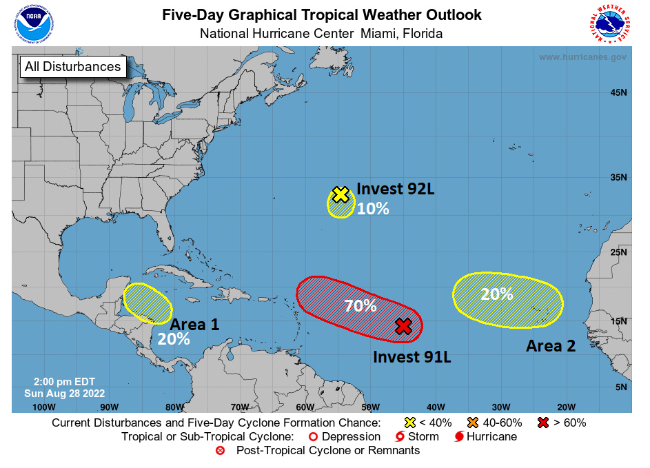
In addition to these four areas, there are some things in the Gulf to watch but none that are likely to develop tropically. We’ll get to all these areas now. Use the map above as your guide.
Area 1 in the Caribbean
Is this a concern for Texas? Not really, but it may help contribute to some rainfall next weekend or after Labor Day
The main area we’ve been watching for a few days now is a disturbance that’s heading into the northwest Caribbean. The GFS model latched onto this system last week, incorrectly it turns out, and was trying to bring this into the Gulf as a substantial storm on occasional runs. Models seem to have latched onto this now and favor a track that’s a bit farther south and into Mexico. Whether it becomes a system or not remains to be seen.
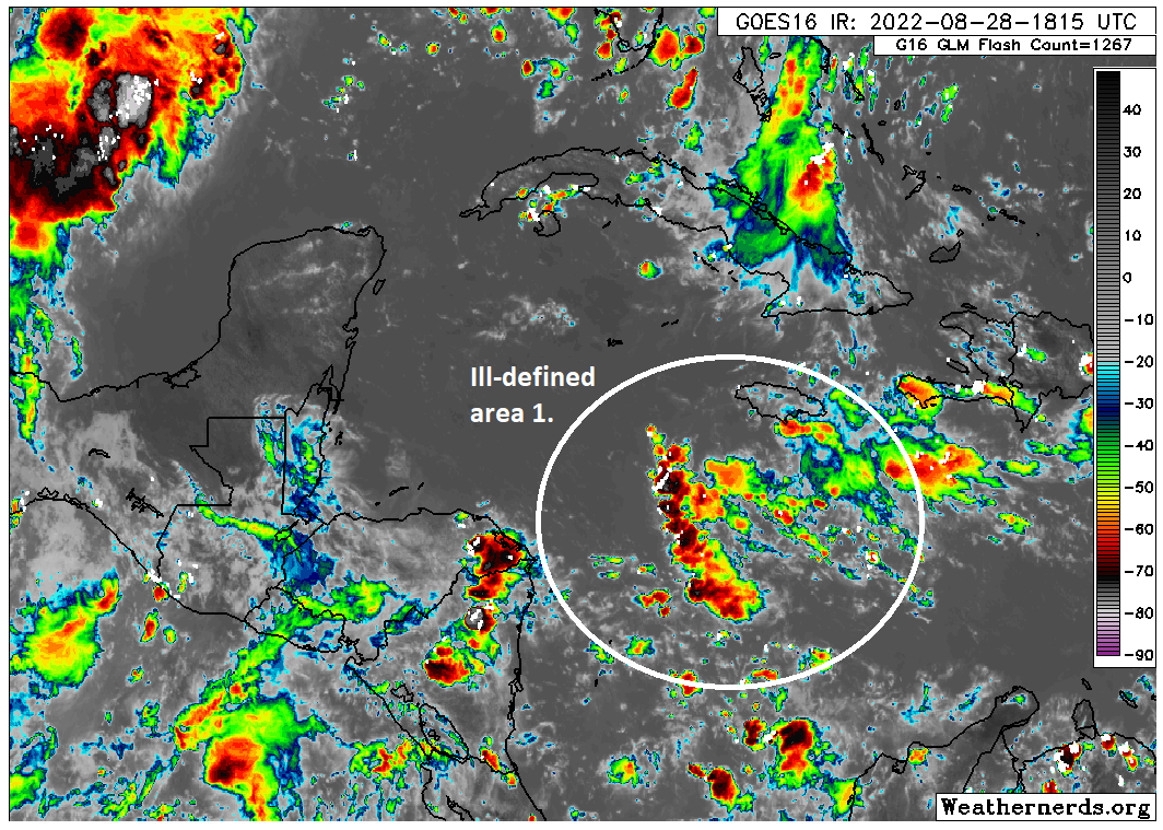
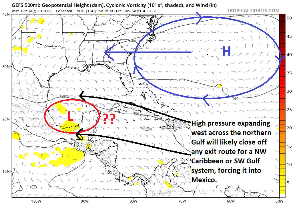
It certainly has a long way to go based on the satellite image above. Why are we confident in this likely staying to our south? Well, for one it’s disorganized. Weaker systems will be less apt to gain latitude and will continue generally off to the west or west-northwest across the Caribbean. The longer this takes to organize, the narrower that exit ramp becomes until perhaps it’s too late and it ends up being forced into Mexico or even Central America.
Even in the case of the more bullish GFS model, one look at the ensemble tells you all you need to know. Wherever the low is this Saturday evening; be it west of the Yucatan over the Bay of Campeche or just approaching the Yucatan, as high pressure builds across the northern Gulf from Bermuda, it will seal off the northward exit door, and even a stronger system would likely be forced into Mexico here. And again, that’s assuming the GFS is correct on developing this…a bit of a stretch right now.
So, at this point, the only real thing this might do in Texas is bring us some rainfall enhancement later next weekend or just after Labor Day. Obviously, we’ll watch for any changes, but at this point, we have limited concerns regarding this system.
Invest 91L
Is this a concern for Texas? At this time, we do not believe this will impact the western Gulf at all.
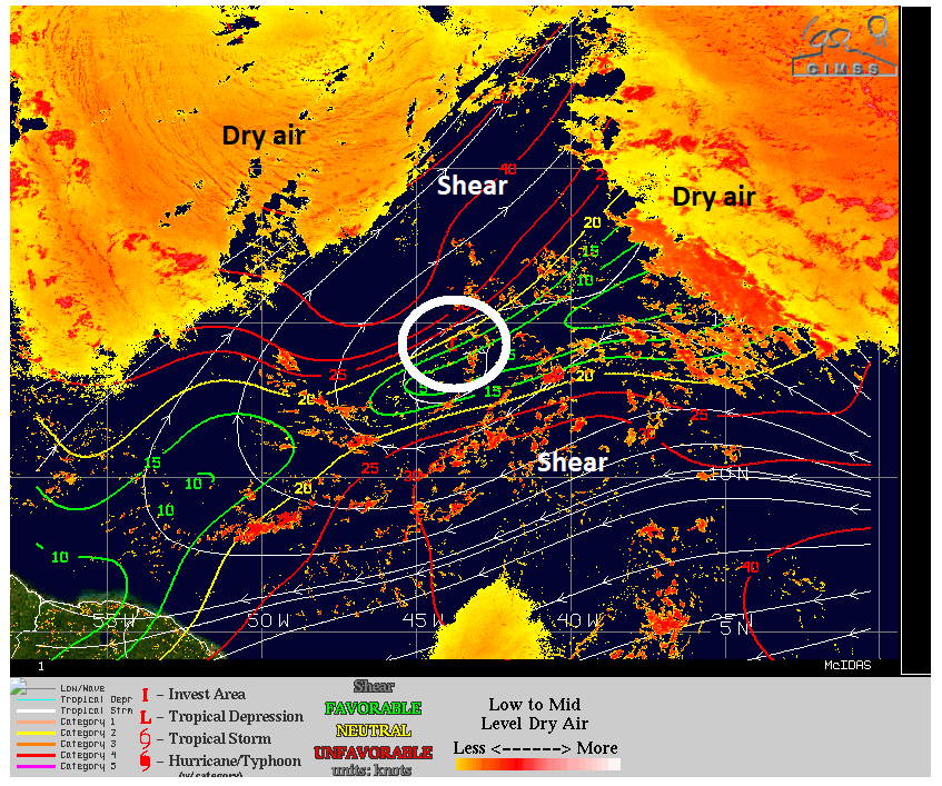
Invest 91L is likely to garner most of the headlines this week. It has the highest chance to develop right now, and it’s likely to be the one that comes closest to the U.S. This one is going to be a bit of a challenge to predict I think, as the steering currents around it, and the organization of the system itself will ultimately impact its track and both seem complicated.
In the near-term, this thing has to fight dry air all around it, compounded in part by pretty aggressive wind shear on either side.
Over the next 3 to 5 days, as this comes west and west-northwest to just northeast of the Lesser Antilles, it will then likely start feeling the effects of shifting steering currents. Initially, those steering currents may keep an exit door open for 91L to turn out to sea. But if it’s too weak to gain that much latitude, it will stay in place and may actually get turned a bit back to the west again, bringing it a bit closer to the Bahamas or Florida perhaps. This would be the result of that high pressure shifting west across the northern Gulf that helps keep area 1 away from Texas. It may also cause it to slow down some as well.
From there, it’s anyone’s guess. At this point, I am not expecting anything major from this, but it’s worth watching in the Southeast or the larger Caribbean islands and Bahamas. But any impacts in those locations are at least 6 to 8 days away. Never say never, obviously, but at this point it seems unlikely to get to the Gulf.
Invest 92L
Is this a concern for Texas? No.
The second invest in the Atlantic is chilling east of Bermuda. It’s no threat to any land mass at this time, and any development would be slow and probably weak.
Area 2 in the deep Atlantic
Is this a concern for Texas: Not right now, and probably not at all.
The last area of note from the NHC is in the far eastern Atlantic. Right now, things are a bit of a sloppy mess out there, with storms, tropical waves, and more — but nothing organized.

What exactly happens out here is TBD. Models are convinced something should come of this, but none of the model data looks especially significant at this point. Some even turn this out to sea before it even gets halfway across the Atlantic. Whatever the case, this is so far away and so disorganized right now, that there’s little we can intelligently say about this area. So we’ll leave it at that for now.
The Gulf
As of Sunday afternoon, there are no areas of interest outlined in the Gulf by the NHC. Looking at satellite here, that may be somewhat tough to believe.
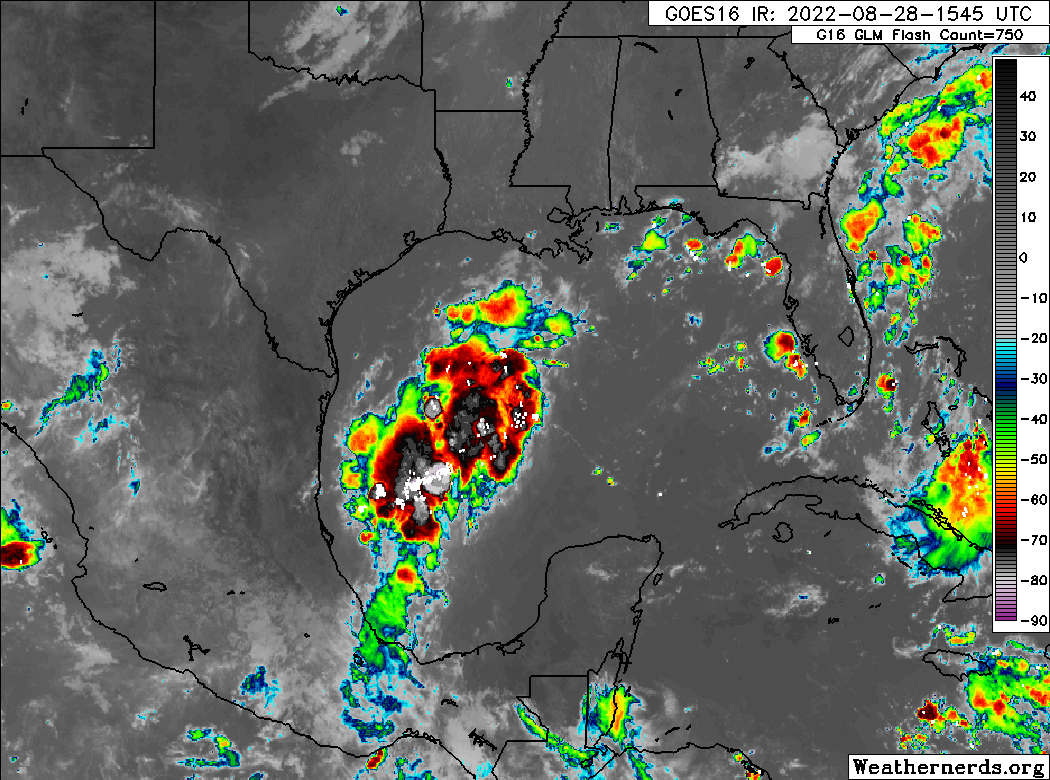
That area of thunderstorms looks better than anything in the tropical Atlantic that’s outlined at this time. But looks are sometimes deceptive. While certainly there is a lot of storm activity in the western Gulf, there is no organization to this area right now, nor is there expected to be. This moisture is expected to come north and northwest over the next 36 hours, and this is likely to enhance our coverage of showers and storms tomorrow and perhaps Tuesday, particularly along the coast but perhaps inland as well. We’ll have more on this for you in our usual Monday morning post, but keep your umbrella handy tomorrow.
Aside from that, the Gulf looks quiet. There are modeling hints of something trying to emerge out of Central America after Labor Day, but it’s so far out and has such modest model support right now that it doesn’t make sense to speculate beyond the fact that we’re always monitoring things this time of year. We’re good this week, and we’ll keep tabs on all the things out there as the week progresses. As good a report as you could ask for on August 28th. More for you tomorrow AM!

As always, thank you for the in-depth, non-hyped, rational analysis.
Thanks for the update. I always look for SCW’s explanations, which are always clear and devoid of the crazy factor.
Thank you for taking time out of your Sunday to post!.
Thank you so much. I was counting on Monday morning’s post for info about the storm outlook, it’s very good to get an update this afternoon.
I appreciate the explicit detail, rationale and reasoning. This is one of the best posts I’ve seen. I had been watching the GFS runs and it seemed like every other run had a system hitting us. Logically, I knew it was too far out to be reasonable, that, and nothing has developed yet, but it still looked scary. Having Space City Weather explain the “behind the scenes” facts helps put it all in perspective and provide peace of mind (for these systems). Thank you for taking time on a Sunday to quell the fears.
Thank you so much for taking time out in a Sunday afternoon to update us.
Thank you for your calm, professional reporting.
What is the date in September that we should aim for, as in when we can start breathing a sigh of some sort of relief?
In the past they’ve usually put that at the 24th.
Thank you. I appreciate the clear cut explanation. And I really appreciate you don’t try to terrify us.
September 22, is the first day of fall and this right around the time we get our first cold front.
Let’s go Artemis!
Excellent reporting. Thanks
Thanks for the updates. Y’all are my go to’s for all weather news. Can’t trust the TV weather forecasts.
Really appreciate you taking the time for a Sunday post, particularly for a tropical update. Hope the rest of your Sunday is great.
Very nice, concise summary of the current hurricane outlook. Thank you!
Thank you!!! I was looking for an update yesterday lol but as I didn’t see one I figured no news is good news! Quickly saw today’s heading and was breathing a sigh of relief before I read it!! Thank you for taking the time on the weekend to post!!! You guys are awesome!!!! Thanks 🙏 !!!
As always, thank you for the information! I greatly appreciate it! 🙏🏼
Thank you for taking time to provide this update!
Thanks for your professionalism about our current weather issues.
Have a relaxing Sunday and always 👍to you and the SCW crew.
Not going to lie, the GFS (and the Navy) model makes me pretty concerned about the Caribbean spot.
I have never seen this level of model disparity between the GFS and everyone else.
Thank you for the weekend update!
Just found your site this am. Thank you for being hype free and direct with your opinion of the forecast. I really do appreciate your style of reporting.
And why is Louisiana worried about Houston.im not what ever hit Houston oh well then it it Houston.everbody gotta be destroyed at sometime or another