The Atlantic is full. No room at the inn, folks. We’re fresh out of vacancy. If only that were true. Since our last tropical update last Tuesday, we’ve added <checks notes> three more storms. We’re running about three weeks ahead of 2005’s pace and the last name on the list is Wilfred before we shift over to the Greek alphabet. You can argue all day about how many of the storms have been minimal, but a storm is a storm and 2020 is certainly in a unique place based on our historical records. Incidentally, if you want to look back at an interesting analog year to this one, check out 1971.
This is when it occurred last in September 1971, from Neil Frank. Six active with another about to form. 🙂 pic.twitter.com/yxZSsEze7D
— David Roth (@DRmetwatch) September 14, 2020
It was also a year full of mostly minor to moderate storms, including Fern in South Texas and Edith near Cameron, LA. But it included six active systems (including Fern & Edith) at once with one additional in the pipeline. Ginger on that map above is noteworthy for being the longest lived modern Atlantic tropical system. It lasted from September 10th through October 7th, before eventually reaching land in North Carolina. That track map is something to behold. Even better, it was drawn by local hurricane legend Neil Frank.
At present, we are monitoring four systems, none of which are a concern for Houston. There are also two “invests,” neither of which are a serious concern for us either. Plus, we have one “untagged” Gulf disturbance.
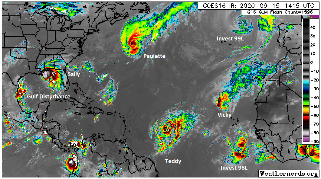
We’ll do our best to sift through the morass for you, starting with that current lineup of storms and then talking the hypothetical systems.
Hurricane Sally
Eric covered Sally earlier today, and not much has changed. Sally remains a category 1 storm with 85 mph winds. It is going to meander just offshore of the Gulf for the next day or so before beginning to move along north and northeast. Water trumps wind in terms of greatest threats with Sally, as persistent onshore flow will keep coastal areas inundated for awhile.
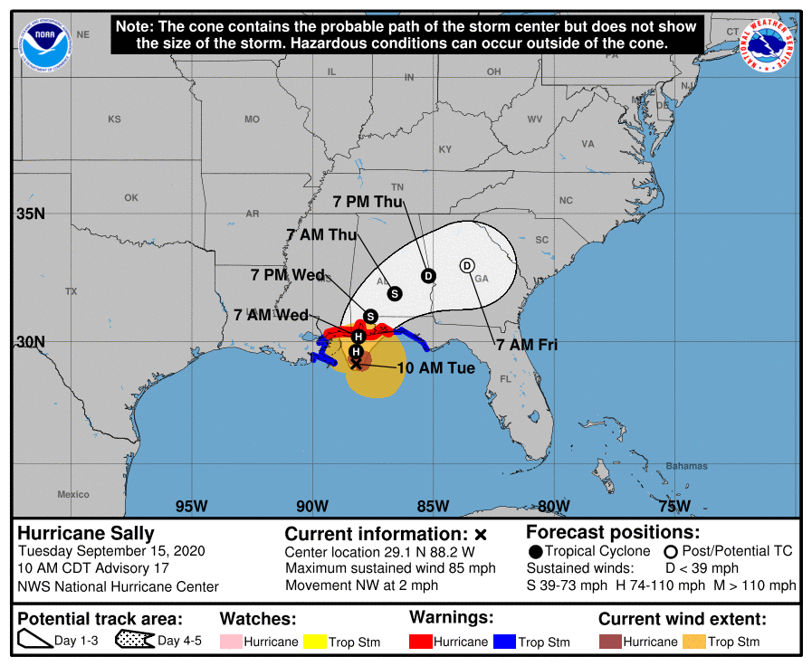
Meanwhile, heavy rainfall will repeatedly pelt southern Mississippi, Alabama, the Florida Panhandle, and eventually Georgia and the Carolinas leading to widespread and potentially severe flash flooding.

Paulette & Teddy
Paulette scored a direct hit on Bermuda yesterday and is now racing out to sea. It is expected to slam on the brakes when it hits about 35°W longitude. It will then stall and drift south, to the west of the Azores Islands, likely dissipating.
Teddy will hopefully speak softly and carry a big stick. It’s expected to blow up into a major hurricane and potentially a high-end one at that by the end of the week as it lifts off to the northwest in the open Atlantic. Teddy’s forecast becomes a bit more uncertain once we get to about Sunday. At that point, models differ between Teddy turning north and then northeast out sea or perhaps staying on a northwest heading for a time. Either way, it isn’t a Gulf concern, and it’s likely not an East Coast concern either. Where this meteorologist is personally curious is if Teddy makes a run for Bermuda. There is precedent for back to back hits on Bermuda, happening in 2014 with Fay followed by Gonzalo six days later.
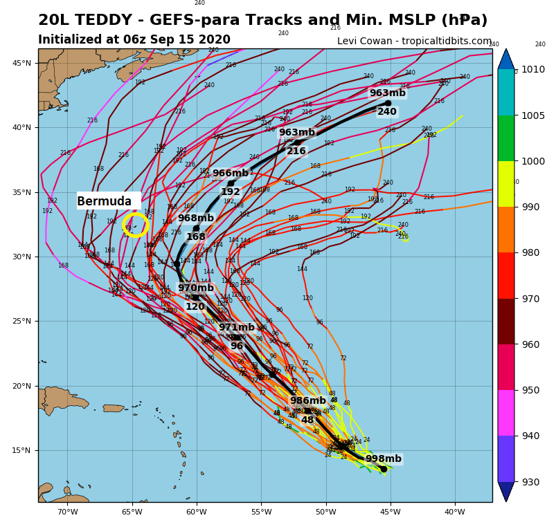
The image above shows the GFS ensemble members (the new version of the GFS ensemble). I’ve circled Bermuda on there, and you can see about 10 to 20 percent of the ensemble members bring a track close to Bermuda. This is similar on the European ensemble as well. We’ll see what happens with Teddy as it comes north.
Rene, Vicky, and Invest 99L
We can close the book on Rene, which dissipated yesterday and is barely perceptible on satellite today between Paulette and Teddy. Vicky was classified as a tropical storm in the extreme east Atlantic based on an ASCAT satellite pass which showed winds of tropical storm force.
Hard to keep track of everything right now, but it appears recent designated #TD21 (formerly Invest #97L) just west of the Cape Verde islands has a number of >35kt wind vectors from a recent #ASCAT pass on its west side.
Will likely be upgraded to a tropical storm today. pic.twitter.com/nCYxE4giMm
— Philippe Papin (@pppapin) September 14, 2020
These satellite passes are incredibly valuable for storms out in the open Atlantic that are of low impact or too far for aircraft to reach. In this case, it allowed a storm that may have previously gone undetected to be classified. I know some folks want to downplay the 2020 season for these reasons, but to be able to use these tools for this purpose is truly a good thing for our records and our research and understanding of tropical systems.
Vicky should degenerate into a depression tomorrow. To the north of Vicky, way to the north, is Invest 99L. While we’ve seen storms work toward Portugal in the past, this may be the farthest northeast that I’ve seen an “invest” area.
Invest 99L looks pretty dang cute! Is this the farthest northeast invest we've ever had? pic.twitter.com/bdE7mTYces
— Matt Lanza (@mattlanza) September 15, 2020
While this is currently over water too cold to allow this to be classified as “tropical,” as it moves south, it could develop into a subtropical or tropical storm later this week. It may flirt with the Iberian coast next week, but it is expected to stay offshore.
Invest 98L
The next wave off Africa has emerged in the deep Atlantic, and it may become a depression or storm. Initially, it seemed this one might stay disorganized enough to come pretty far west, slipping underneath Teddy to the north and eventually finding itself in the islands. But if you look at 98L on satellite this morning (scroll back up) and you look at the current model data, it seems this one may develop.
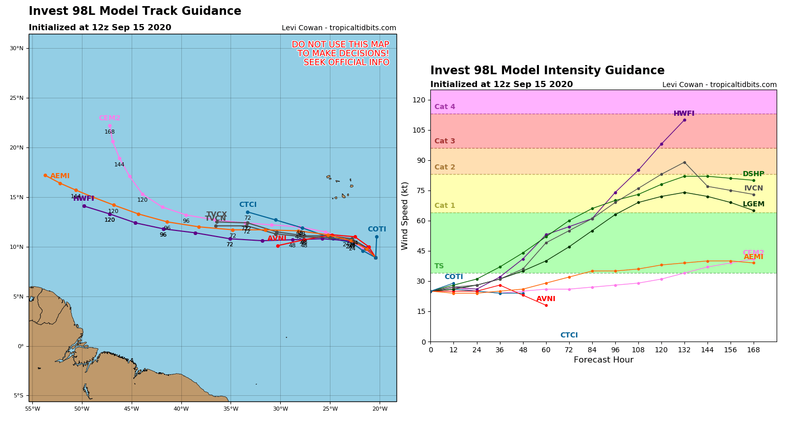
Models have certainly become more bullish on 98L intensifying a bit as we head into the weekend. While I think a model like the HWRF in this case is a bit too aggressive (strengthening it to Cat 3), given that it already has a skeleton of structure in place, it’s not asking much for 98L to become a depression or tropical storm by the weekend. And indeed, the National Hurricane Center says this has a 70 percent chance of development over the next five days. Will this become a threat to the Gulf? It’s unlikely. Even if it did, it would still be 12 to 14 days out. No reliable model shows it running the full gauntlet to the Gulf, and it seems fairly unlikely to happen if it strengthens as expected. So we don’t need to worry much about this one for now.
But wait, there’s more!
Coming back close to home, we have a weak area of low pressure just kind of meandering in the southwest Gulf of Mexico.
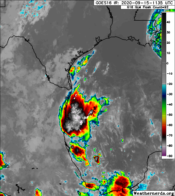
Over the next couple days this is not going to move much, which is going to lead to repeating rounds of thunderstorms south of Corpus Christi and into Mexico. This gets a little curious heading into later this week and next week. That low is going to fester for several days. In some ways, this reminds me a bit of Hurricane Katia back in 2017 that, if you’ll recall meandered down that way after Harvey before moving into Mexico. Modeling is less supportive of this system than Katia, but it’s the same sort of idea. The Euro ensemble only has about 20 percent of its 51 members showing any development of this area over the next seven days, and those that do show development stay on the weak side.
However, given the loose organization of this disturbance today and the potential addition of a dying cold front this weekend, I think the broader southwest Gulf will need to be watched. If not for an organized tropical system then for a potentially heavy rain event close to the coast. Models have been spitting out some rather prodigious amounts of precipitation offshore at times over the next 10 days or so. The key phrase there is offshore. But with that in mind, any shift in location or orientation of the front or this disturbance could yield a shift in where some of that heavy rainfall ends up, perhaps including South Texas. So while we aren’t particularly worried about this area, we do feel it’s one to keep an eye on.
Obviously, there’s a lot going on right now. It can almost feel overwhelming. But the good news is that we’re approaching the end of traditional hurricane season in Texas; and while we certainly wouldn’t say we’re “safe” at this point, given the abundance of action out there, that we only have one area to watch is a small victory in and of itself.
Note from Reliant
Our thoughts are with everyone in the path of Hurricane Sally and those still recovering from Hurricane Laura. As a longtime partner to Space City Weather, Reliant recognizes how important it is to stay informed during severe weather events. We are proud to power this site and help bring a valuable resource to our community, both in Texas and beyond. Our sincere thanks and “tip of the hat” to Eric and Matt as they continue to bring these important updates during hurricane season in the Gulf. To our neighbors to the East, stay safe and we encourage you to reach out to your local utility provider if you need assistance with your power during this time.
Surely I’m not the only one who can’t get this song out of my head now: “I’m going to get me a Neil Frank hair cut. Totally flat on top of my head!” 🙂
Much appreciated guys. I keep spreading the word about SC Weather and you guys haven’t proved me wrong. Thanks for what you do.
I appreciate the comments about the low in the southwest part of the Gulf. It has been bothering me for the past couple of days. I am just ready for this hurricane season to be over.
Now I have a song stuck in my head … Don’t walk away Rene …
Apparently I couldn’t hear the lyrics too well on my 1970s staticky transistor radio 🤣
So where does that put us for ACE intensity for the year?
Here you go:
http://climatlas.com/tropical/
According to Colorado State, we’re at an ACE of 63 (+10 vs. normal). http://tropical.atmos.colostate.edu/Realtime/index.php?loc=northatlantic
Ah 1971. I’ll always remember Edith which dropped a tornado on my high school in Baton Rouge.
I noticed that NHC has Teddy forecast as the second major hurricane of the season. Yes I remember that you don’t need to be a major to do damage but I’m curious about the significance, if any, of the fact that there have been so many small storms. Is there a takeaway that we can feed our mental models with?
The only takeaway this season (that I see) is that while the preseason forecasts for a busy year were accurate, that most storms struggled speaks to something in the background holding them back…be it dry air or shear or something. So I’ll be curious if there’s a postseason analysis that shows why that is. It also further underscores that preseason hurricane forecasts have little real world value to most people besides curiosity. A crazy busy year with only one major landfalling storm in the US means a lot of different things to a lot of different people that can never be captured in a preseason forecast with any degree of accuracy.
Why are Y and Z not used in naming tropical storms? There are plenty of Y and Z names. Yvonne, Yancy, Yanis, Zara, Zander, Zada.
My dear Fulgencio would be very pleased by a storm named after one of our most amazing friends the strapping Walloon Zénobe!!
Someone somewhere decided that there weren’t enough is my guess. I do wonder if that will eventually change.
Are the sea surface temps on a par with the 2005 season?
The Gulf is warmer than 2005 at this point. The Caribbean is fairly similar, and the Atlantic is at or above 2005 levels in many areas.
A friend of mine from Alexandria posed this question and I was wondering if there was a meteorological answer…
I wonder if the rain from Sally, when it gets to the east coast, will knock down the smoke/smog from the smoke in air coming from the west coast fires???
It could help I guess, as rain would help literally “rain” particles out of the atmosphere. But time and a cold front would be a bigger help up that way since Sally is expected to only get up to about the Carolinas.
Identifying storms as what they are is what we should always be doing. That helps us build more accurate models. What grinds my teeth is our need to set records or compare between year dates when we reach some alphabetical point. Due to between year variation in technology all that is comparing apples to elephants. It adds to public misconception. It strengthens the climate change denier argument by using demonstrably false comparisons. It has a faint aroma of politically motivated misinformation that erodes everyone’s confidence in published information. In keeping with SCW anti-hype theme can we please stop with the between year score keeping. It’s another way we can become part of the solution.
I hear what you’re saying here. The problem with just ignoring it is that a.) people are smart…they know this is way busier than normal. So they want to understand why. And b.) if we just didn’t address it, we’d be bombarded with questions from people about why it’s happening. I’d rather front-run b.) and give people credit for a.). The reality is that we actually do a pretty good job with our hurricane history. The NHC folks know what they’re doing when they reanalyze past seasons and they take a lot into account. I have confidence that at least since like 1980, we have maybe only a few storms that were missed. So even if you say, “Ok, compared to any of the last 40 seasons, this stands alone in terms of activity,” that’s still impressive and it’s more than likely accurate. So I understand what your point is here, and it’s why whenever we do discuss this we make sure to note that this is a unique time relative to past seasons. We can’t just pretend it isn’t happening though, so we have to address it but try to emphasize that while it’s impressive, it’s mostly something interesting from the last 30-40 years.
Thanks for the thoughtful response Matt!
It is easy for me to take a hardline position as a reader. I’m sure that I would be more balanced if I was in your shoes as the content provider. You guys usually do put at least an implied asterisk on the alphabet/date scorecard so I am guilty of some overreaction here. I certainly sympathize with point B while point A made me chuckle while appreciating your diplomacy.
Great work Matt…thanks…I’m worn out!
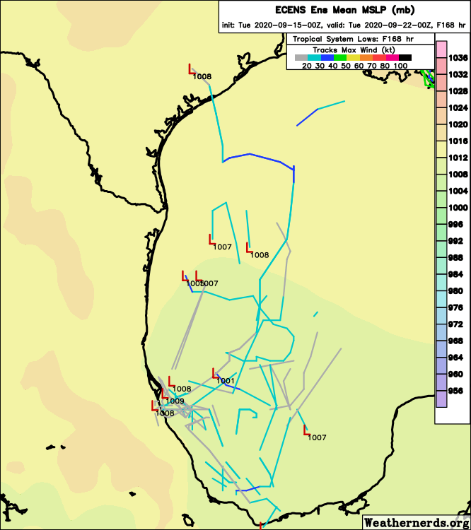
The 15z ECENS looks pretty bullish on the Gulf disturbance for next week… 🤔
Doh, 12z
Thank you so much for keeping everyone informed with timely, reliable information. The graphics are very helpful and I appreciate you sharing them!
Hey Matt, it’s a bit late in the day and will be gone by next Tuesday but I was watching the satellite feed in today’s Tropical Tidbits update and there was a pretty weak but attractive system that looks like it popped up over the last day or so off the coast of Spain (45N/20W). Id guess it comes from some remnants, but how often do those develop?
Not a remnants! That’s invest 99L discussed in the post. The clearest example I can think of in that area is Vince back in 2005, which made landfall as a depression in Spain. https://en.wikipedia.org/wiki/Hurricane_Vince It apparently was the first storm to make landfall in Iberia since 1842. There have been close passes in the last few years too. But as far as “genesis” goes, I cannot recall an initial disturbance that far north and east.
Thanks for clarifying. That’s what I get for reading the emails and skipping the “read more” link before commenting.
I hang my head in shame.
Ahhh, Neil Frank. Known not only for his hurricane forecasts, but for lodging isobars firmly in the memory and vocabulary of every viewer. Every forecaster has his favorite bit of weather analysis, so we learn from all of them, yet for me Neil is at the top. Thank you, Neil!