As we’ve been telling you for essentially weeks now, the tropics are becoming very active. Some of this is just basic math—as we approach late August and September, the tropics usually come alive. But there is more at play this year, with things happening in the background that should allow for basically an “outbreak” of sorts of tropical systems across the Atlantic basin in the days ahead.
Tropical outlook in a sentence
There will be at least two legitimate opportunities for tropical systems to develop and potentially impact some part of the Gulf of Mexico over the next 10 days, and an additional system or two may develop farther out in the Atlantic as well.
Invest 97L: First in line
The system the models are most bullish on is Invest 98L, which we’ll discuss below. But the one we are most concerned with more immediately is Invest 97L, because this is closer to us, and it is the type of system that can sneak up on us and cause some problems.
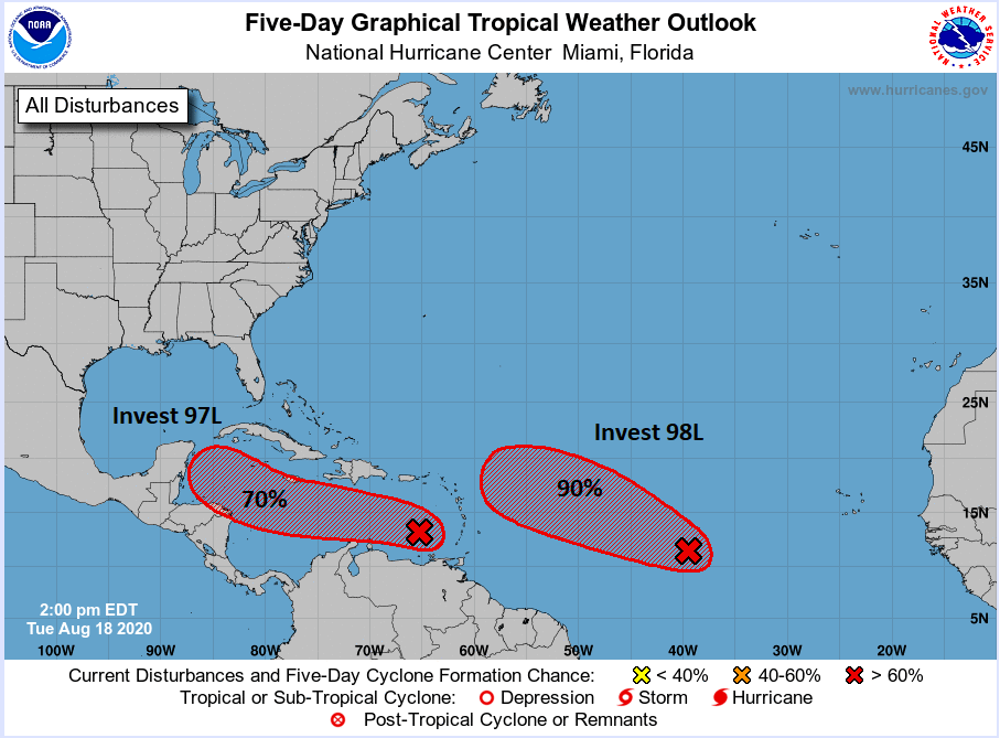
Invest 97L is currently over the eastern Caribbean Sea. It’s not terribly well organized, and you can see a satellite loop from Tuesday afternoon showing mostly just a “blob” of storms at this point.
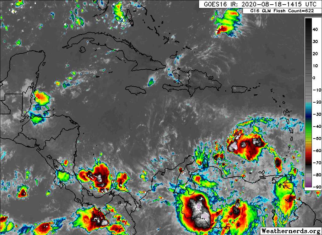
Over the next few days, 97L will plod along in the Caribbean, interacting at times with a disturbance over South America. So development is only expected to be slow or gradual. Eventually, it will end up in the western Caribbean, somewhere near the coast of Honduras or the Yucatan. I can hear 75% of our audience now saying, “Wait, that’s how Harvey happened, right?” And the answer is, “Sort of, yes.” It’s the elephant in the room here, obviously, so let’s discuss and compare real quick.
By the time the disturbance gets into the Western Caribbean this weekend, the upper air pattern will be favorable for it to gradually lift north. Here’s a map from the GFS ensemble valid on Saturday afternoon. We’re looking at the 500 mb level, or about 20,000 feet up, basically the large-scale steering pattern for this time.
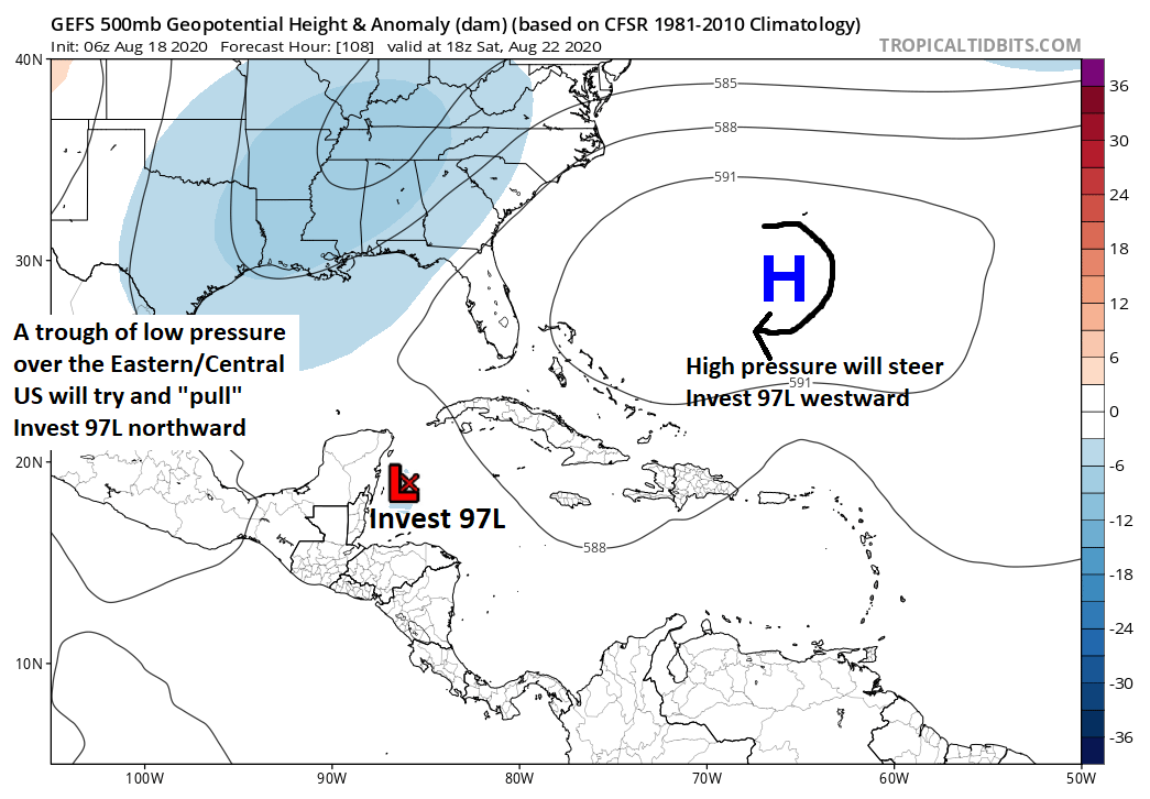
On Saturday afternoon, 97L should be off the Yucatan or Belize or just north of Honduras. It will be steered to the west by high pressure near Bermuda, while at the same time, a trough of low pressure in the upper atmosphere over the Lower Mississippi Valley is going to try and “pull” Invest 97L to the north. So at this point, the system should be moving to the northwest.
So in that respect, a middling system that gets pulled north and west across the Yucatan and into the Gulf of Mexico, Invest 97L is similar to Harvey. But I’m going to intentionally stop with the similarities there because the potential of what this does is much different from Harvey.
There is a chance that the trough remains strong enough to continue in its effort to “capture” Invest 97L, allowing it to come north into the Gulf and toward Louisiana or perhaps the Upper Texas Coast. That scenario can’t be ruled out. There is also a chance that Invest 97L gets “missed” by the trough and ends up stationary without much to steer it over the Gulf of Mexico. While that’s not a huge rainmaker on land, that becomes problematic because there would be a chance Invest 97L could strengthen while sitting offshore. Another possibility is that the Bermuda high continues to expand so much so that it just pushes 97L into Mexico as a weak rainmaker. Harvey was a once in a lifetime storm in terms of rainfall, so we don’t want folks to worry about a “Harvey” type storm right now. There are indeed some similarities in the initial overall big picture, yes. But that’s where it ends right now. What we should be doing (and what Eric and myself will be doing) is making sure we are prepared to take action late this weekend or early next week just in case it becomes clear that 97L will become a problem for us. We will keep you posted.

Invest 98L: Next in line
The second system of note is Invest 98L, which is about 1,000 miles west of the Cabo Verde Islands and moving west toward the Lesser Antilles rather quickly. The problem with Invest 98L is significant however, in that we don’t have a true center to fixate on right now. In fact, if you look at satellite, the wave is stretched out over about 800 to 1,000 miles.
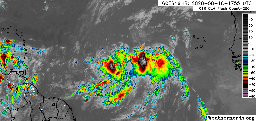
So honing in on which part of this wave actually develops has significant implications on both track and intensity going forward. What we can say is that overall the pattern looks conducive to allow 98L to generally track west, while gaining some gradual latitude (in other words about a WNW heading). In about 5 days, we would expect whatever 98L is to be located somewhere in the Caribbean islands.
The concern with 98L’s track is that as this comes west, it will do so concurrently with an expanding, sprawling area of high pressure over the Atlantic, the one we noted in 97L’s section that could build into the Gulf.
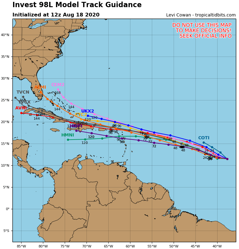
That basically should “block” the escape route for 98L, meaning it could perhaps eventually stop gaining latitude and bend back to the west, pushing it closer to either the Gulf or the Southeast U.S. coast. The question at that point revolves around intensity, and that’s one we don’t have a good answer for at this time. If the storm “island hops” over Puerto Rico and Hispaniola, it will likely impact the structure a good bit. If it stays just north of the islands, some of its circulation could be impacted by land interaction, but that would be offset by the storm being over warm water. At this point, it’s tough to think 98L will go south of the islands, but that’s not completely out of the question either.
Basically, we have more questions than answers today. Either way, 98L, whatever “it” is should end up near the Southeast coast or Gulf in about a week. From there, it would likely be steered around the periphery of the Bermuda high. If that keeps expanding into the Gulf, it will keep coming west before turning, which would bring it closer to Texas or Louisiana. If the high stops expanding or the storm becomes very strong, it would likely turn north before getting to our neck of the woods. We simply don’t have answers to those questions right now, and it is critical that we (and anyone on the Gulf Coast from Mexico to Florida) continue to monitor the progress of both 97L and 98L in the days ahead.
Additional systems
Beyond 97 and 98L, we will likely have at least one, possibly two more systems to track in the deep Atlantic. To be frank, we aren’t really worried about these ones at this point because of what we have in front of us at the moment. Still, we’ll keep you posted with an update in next week’s Eye on the Tropics.
Power outages during storms
Here’s a quick reminder from our sponsor, Reliant Energy, that power outages can disrupt your life and even be disastrous if you have critical electric appliances and equipment in your home. A permanently installed generator, which can switch on within seconds of a power outage, can ensure your home stays powered during a storm. There are many types, depending on if you want to power your entire house or only specific areas or appliances.
What kind and size of generator do I need?
- The more items you want to run, the more powerful your generator needs to be.
- In general, a 10kW to 14kW permanent generator can run basic survival appliances (refrigerator, HVAC and some lights).
- A 15kW to 20kW generator can run a small home (no AC) and 21kW to 25kW can run a small to medium-sized home, with the higher kW generators able to support an AC system.
- If you’re interested in a home generator, click here to learn more or request a free in-home assessment from Reliant to help you determine the best generator for your needs and budget.
For smaller appliances and devices, a portable generator may deliver the power you need, like these solar-powered options from Reliant’s sister company Goal Zero, which use advanced battery technology to draw power from the sun and can even be run safely indoors, unlike gasoline-powered generators.
Seriously not sure how much longer I can live in Houston. This feels harder every summer. The idea of evacuating for a hurricane during COVID19 is definitely panic-attack-inducing.
I lived here forty years. Through Alicia, Ike, Harvey and multiple other tropical storms. It’s a fact of life along the coasts. The north has blizzards and we have storms and hurricanes. The key is preparing. Control what you can control. I think one or two areas will probably be impacted by major hurricanes this year ugh maybe more. We are just in this hyperactive period right now unfortunately.
I got nervous during hurricanes before since I only moved to Houston 10 years ago and didn’t grow up with this way of life. But now that my house has flooded (Imelda), I have real fear. Saying “be prepared” and recognizing it’s out of your control is not really helpful when you know you might lose everything. Again. I completely understand the feeling that it seems to get harder every season.
We flooded with Harvey and it was devastating for our family and many others. All we can do is hope for the best and prepare for the worst. While yes its stressful, I won’t live in fear of what I can’t control.
When talking about hurricanes hitting US, why you all ALWAYS forget that Puerto Rico is US?
When y’all say you’re preparing in case this becomes problematic for us, what are you doing exactly?
Brush up on your storm checklist. Things like filling the gas tank up. Buying a few more non perishable items and water. If you’re on the coast, planning on what you intend to do if a storm comes this way. It’s all about staying ahead of the curve. There are multiple online sites and YouTube videos regarding hurricane checklists.
Thanks, Matt and Eric for keeping our general panic level, post-Harvey from bubbling up to the surface. You give such solid, no hype information, and we appreciate it so very much!
We need a little rain (in very manageable quantities, please) and a break from the heat, but NO Harveys and NO Ikes!
As someone who was here during Allison 2001 and Harvey, I’m going to raise an eyebrow about the line “once in a lifetime storm.” 😉 😛
That said, no need to panic. All we can do is prepare for the worst and avoid all local news stations. They’re already posting the headlines. I trust Eric and Matt to keep us well informed.
I’m with Lisa. As aoon as I read “Once in a lifetime rainfall…” I thought, “Maybe in dog life…”
Given that Harvey was worse than Alicia, it’s not an unreasonable statement.
Well, I guess I’d better head over to Spec’s…..
Thanks Eric and Matt!
Thanks, Eric and Matt! Can you please address what impact 97L could have on 98L? If the first one comes in here in varying levels of intensity, does that make a difference in whether the second could follow it in? If it became stronger, and the second followed it, would that keep the second from developing as much? Or are they completely independent of each other? Thanks for your insight!
Do sandbags work here? We are new to TX and haven’t experienced a serious storm yet. In CA we used sandbags to keep water from entering the house when we had big storms. Why don’t I see them here? And if they do work, where can I buy some?