Houston’s weather for the next several days will be influenced by high pressure to our west, and a slightly drier atmosphere thanks to a more northerly flow. By this weekend our eyes will turn toward the Gulf of Mexico, and the potential for a tropical system to disrupt our weather. We still have a lot of questions about Invest 97L in terms of intensity and track, but it seems clear that this tropical wave will move into the Gulf of Mexico. More below.

Wednesday
Conditions will be quite warm today as a northerly flow continues to bring slightly drier air into the region. Dry air warms faster, so we can probably expect highs to reach into the upper 90s for most of the metro area. Rain chances remain near zero with the abundance of dry air. Our evening and overnight weather should again feel slightly drier, although the effect will be more pronounced for inland areas. For August, we can’t complain.
Thursday and Friday
The pattern remains more or less the same for the rest of the work week, although we anticipate winds turning from the north to the east on Thursday, and this will slowly modify our air mass to become a bit more moist. Look for highs in the mid- to upper-90s, which should not be too extreme. Lows should fall into the mid-70s, which is tolerably pleasant for the depths of August. A few stray showers may develop near the coast on these days, but we don’t anticipate any organized rainfall.

Saturday and Sunday
For the weekend we can probably rinse and repeat. We anticipate sunny skies with highs in the mid-90s. Some scattered showers are again possible, but mostly these should be hot, August days like you’d expect.
Next week
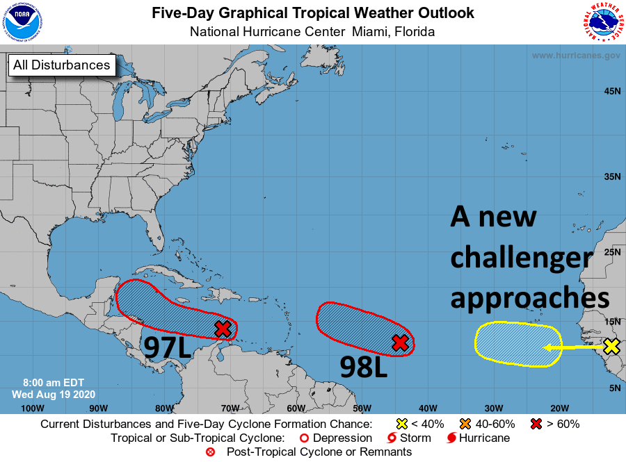
Our weather next week is wholly dependent on the tropics. There remain two systems that may develop. One, Invest 97L, is in the Caribbean Sea, and the other 98L, is moving west-northwest across the Atlantic. For now we’re going to focus on 97L because it is closer, and likely presents the larger threat to the western Gulf of Mexico.
On Tuesday, Matt did an excellent job of summarizing the situation with 97L, and all of its uncertainties. Quite frankly, we still do not have a good handle on where it will go, or how strong it will become. Generally, what is now a fairly disorganized tropical wave should move west and reach the Yucatan Peninsula sometime this weekend. After that there are a couple of possibilities.
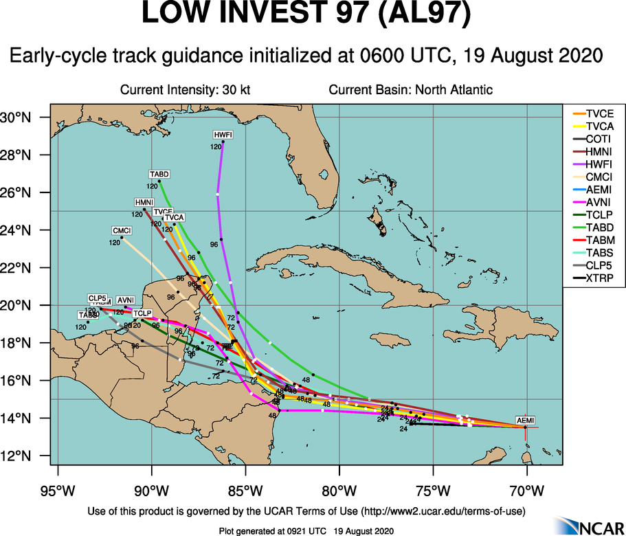
If the system strengthens over the next couple of days, it is more likely to be pulled north, into the central Gulf of Mexico, and then toward Louisiana or the Florida panhandle. Under this scenario it could well become a hurricane. If the system remains weaker, it likely plows into the Bay of Campeche, and takes a more westward track into Mexico or South Texas by Monday or Tuesday of next week as more of a rainmaker. Needless to say all of these scenarios are still in play, and considerable uncertainty will likely remain until 97L starts to develop. Matt or myself will be back this afternoon to provide an update on this system, and of course we’ll be with you through the duration.
“…and of course we’ll be with you through the duration.”
This last bit was strangely comforting. Thank you for all the updates.
I remember the late KPRC weatherman Doug Johnson used to say “When you get one of these systems in the ‘envelope’ you better pay attention.” The ‘envelope’ was the area between Cuba and South America and he opined that these storms always ended up in the Gulf.
Thank you, Eric and Matt, for your loyal service to our community. I am aware that your willingness to share your nights and weekends to manage all of our expectations comes at expense to your family and personal lives. I am also aware that a busy Atlantic basin in late summer means more time on duty for both of you. We feel grateful for your expertise and dedication!
Thank you so much! for your time and dedication to help us know what to expect.
I moved from Seattle to Houston in January and you guys are my go to for weather, I appreciate you! You are very much like the Cliff Mass blog we have in seattle, trusted, no frills, steady eddy
Thanks for keeping us updated. If this does decide to hit somewhere between Houston and Florida, when do you anticipate that happening? Driving to Houston from Florida this weekend and want to leave when it is safest!
Oof, this isn’t looking too good for the Gulf right now… I’m pretty sure the GOM water temperatures are through the roof.