My friends it has been a long—so very long —summer. We have seen record warmth in June and July, and plenty of high temperatures in the upper 90s during the last week. A total of 131 days have come and gone since Houston’s high temperature first hit 95 degrees this year, on May 18. Fortunately, I’m pretty confident that today is the last day of summer 2022.
Oh, we’re still going to see some 90-degree days. There will still be some humidity, of course. But our first real front pushes in today, bringing with it a nice surge of drier air tonight. By Tuesday morning it’s going to feel quite a bit different outside. No, the days won’t be chilly, but the nights will feel like fall. And the dry air is going to feel pretty amazing. Additionally, unlike a lot of early fall fronts, this one will have sticking power. The dry air should last into the weekend. So enjoy what’s coming, because you earned it.
Meanwhile, there’s likely to be a major hurricane coming to Florida this week. We’ll discuss that below as well.
Monday
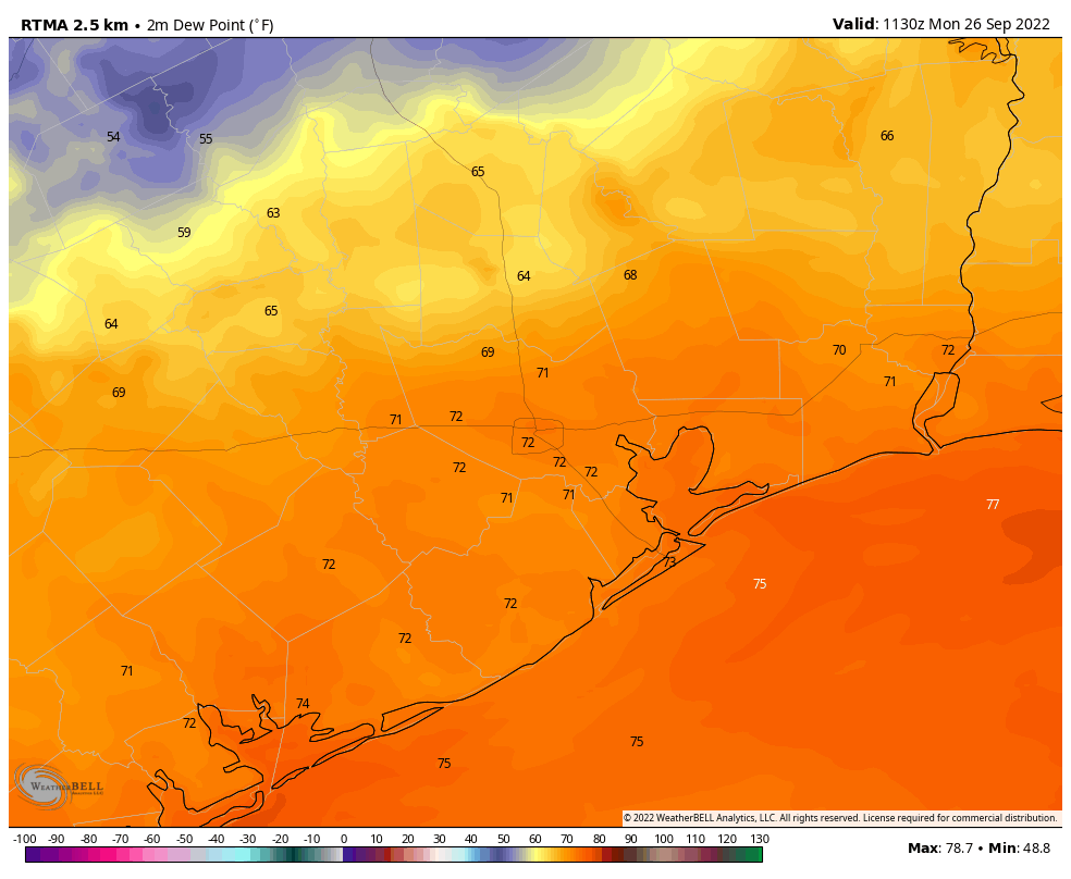
There’s no way to sugarcoat the fact that today is going to be hot again. Expect highs to generally reach the low-90s across the region, with sunny skies. Light winds will turn to come from the northeast later today as the front pushes into the area. We don’t expect much (if any) precipitation with this front, and the bulk of the dry air will lag its passage, moving in tonight. Low temperatures tonight should drop into the mid-60s in Houston, with cooler conditions inland.
Tuesday
You’ll be able to feel the drier air when you step outside on Tuesday morning. The lower humidity, combined with sunny skies, should allow highs to push into the upper 80s to 90 degrees, but temperatures will start falling fairly quickly after the sun goes down. Look for overnight lows in the mid-60s again in Houston, with cooler weather further inland.
Wednesday, Thursday, and Friday
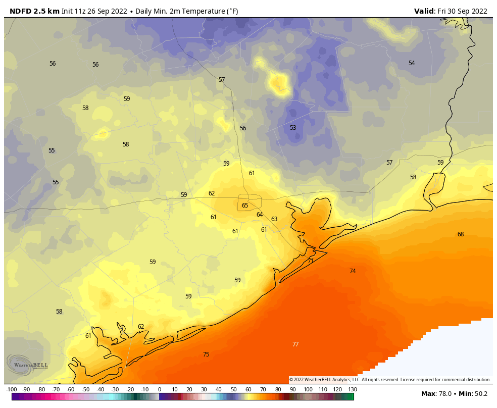
If anything, the flow of drier air should become more pronounced during the second half of the week as Hurricane Ian moves into the eastern Gulf of Mexico. This should allow for warm, sunny days in the upper 80s and lows in the 50s (inland) and lower 60s for Houston. Mornings and evenings will be spectacular, y’all.
Saturday, Sunday, and beyond
By Saturday or Sunday, the onshore flow will probably start to reestablish itself. But at this point I still think we’re going to see sunny days in the upper 80s with at least somewhat drier air. Nighttime temperatures will start to warm, but should remain in the 60s. Highs next week probably climb back to around 90 degrees. I know we could really use some rainfall, but there appears to be precious little of that in the cards for the next 10 days or so.
Hurricane Ian
Ian continues to organize this morning, and has become a hurricane. This is the Atlantic season’s fourth hurricane and confidence is high that it will cross Cuba tomorrow and move into the southeastern Gulf of Mexico. By Wednesday it should be approaching the Tampa area on the West coast of Florida, where it could bring historic wind and storm surge damage. However after Wednesday there is considerable uncertainty about whether Ian will plow into Tampa Bay, move more or less due north up the West coast of Florida, or remain 50 or 100 miles offshore while turning north for the Big Bend region of Florida.
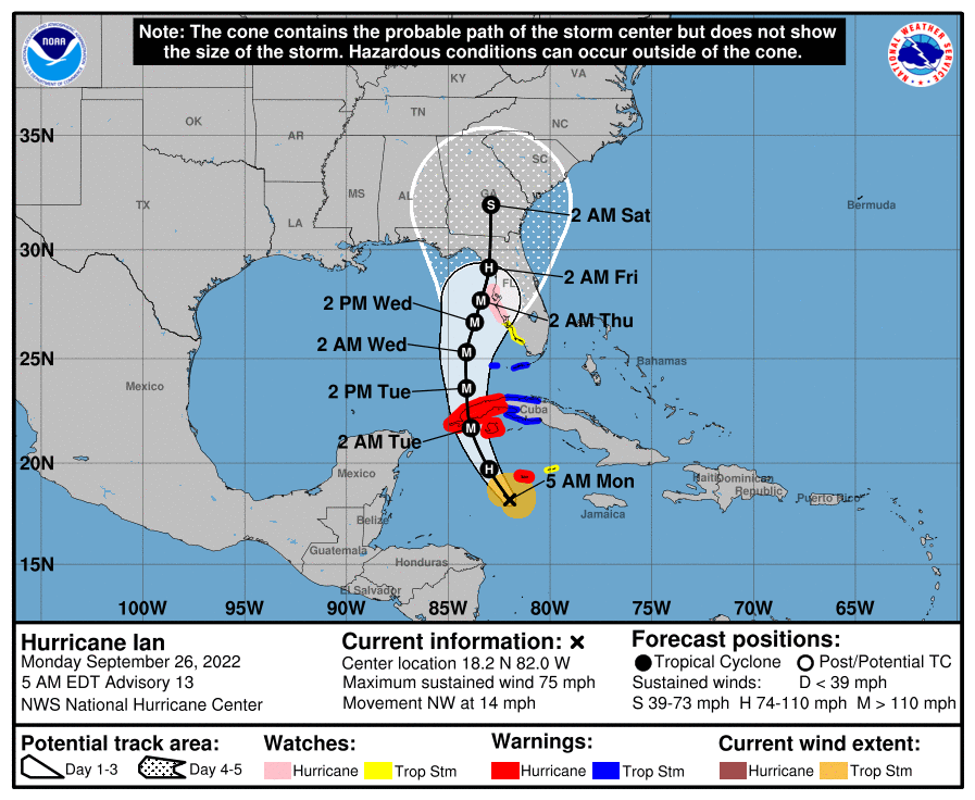
I’ve been tracking the potential impacts on NASA’s Artemis I mission closely. The large Space Launch System rocket and Orion spacecraft remain on the launch pad at Kennedy Space Center, on the east coast of the state. At least minor impacts are likely, and Ian’s effects could become more direct. As of this morning, the probability of tropical storm force winds at the space center are 60 percent, with an 8 percent chance of hurricane-force winds. They could arrive as early as Wednesday. NASA officials are meeting at 11am CT today to decide whether to roll the Artemis I mission back inside the Vehicle Assembly Building to protect the vehicle.


With the dry front passage, this effectively puts the padlock on our hurricane season.
See you next season.
Don’t jinx us…
What effect does high pressure cells have on diverting hurricanes from Texas?
Hurricanes are extreme low pressure. The easy way to put it is that high pressure repulses/diverts low pressure systems
A case of Go fever at the Cape, Oct 2nd looks great for Artemis 1…
NASA rolling back SLS to VAB,,,first movement off 39B at 11p EDT
They REALLY don’t want Starship to make it to orbit before SLS.
I live in east Tampa, deciding whether to evacuate. Have the American and European models come any closer to agreement? Thanks for all you do to keep us safe and sane! W
You should listen to your local authorities on evacuation orders timing
Your storm surge maps are scary, definitely get out if you’re in those regions. It looks like Ian can mess a lot of people up in Tampa just passing by.
Good luck!
Hang tough, Florida! Boy am I glad my older father moved away from Fort Myers two years ago.
Also, I hope the stuff at the Cape is okay – I know that moving the rocket back inside certainly throws a wrench in the works, but better safe than sorry, as the kids say. 😉 That does make me sad, though.
Thanks for all your excellent work on keeping us informed.
My husband is scheduled to go fly fishing in the Keys Thursday through Monday. What are the chances he will actually get to go?
Let’s light this candle!
where is the rain????
Thank you so much for updates on Ian. My son lives in Sarasota and this is his first hurricane experience. I appreciated any information you can provide.
I used to live in Houston, moved to Florida two years ago. I always seek you out for hurricane coverage. Thank you so much for posting about such storms even when they don’t impact Houston! Appreciate all that you do to provide sane and rational observations!
The only good thing about the summer of 2022 is that we had no hurricane to deal with. Otherwise, it’s been a miserable one.
Well, in my book that “only good thing” is actually a humongously great thing. Yes, this summer has been miserable as far as high heat and too little rain are concerned – but I’ll choose that misery over the suffering meted out by another Ike or Harvey any old summer.
Thanks for the regular updates on Ian…even living in Houston, I feel for our Gulf friends in Western Florida. Amazing too how an accident of timing, a fall frontal passage at the “traditional” end of the Texas hurricane season, ensured Ian stayed well east of us. I always feel bad when a storm is churning and my first thought is “go elsewhere”.
Never fall for the first fall front in late September. Summer like weather always returns for a little bit in early to mid October.
Everybody likes summer weather the best, nobody enjoys cold and dark weather. Beaches and pools are better than sitting inside, the girls in their summer clothes are nice, and of course summer is when all of the fruits are in season.
Are we now at the end of Texas’s hurricane season?
I heard Eric say so on “Houston Matters” this morning.
Sad that all the doom and gloomers aren’t posting anymore. SIKE. Stay out of here with that nonsense.
But seriously, thanks SCW as always for your diligence in keeping us updated. Especially when you guys roll out weekend updates. Greatly appreciated.
We are going to travel from SFO to FLL, connecting in IAH on Thursday PM. Should we change to connect through Newark/EWR on Friday morning instead? Ian will be weaker by then but moving north.
Love the Hot & Cold…just love Houston, Texas