Good morning. Another round of surprisingly nasty showers popped up on Monday—I know because about 2.5 inches fell in short order right on top of my home—but we should be done with that for awhile. We should remain in a more or less late summer pattern for the next 10 days or so, after which time we can probably reasonably expect a cold front to be near at hand. We also discuss the tropics today, which you really should not be worrying about.
Tuesday
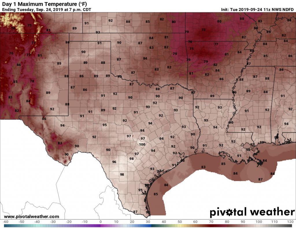
Today should be hot and sunny. With high pressure building from the east and a drying atmosphere, rain chances should fall back to near zero. Highs will be around 90 degrees, with lows tonight in the low 70s. It’s not fall, certainly, but at least it’s not the dead of summer.
Wednesday and Thursday
These days should bring more of the same, with only very slight rain chances and mostly sunny skies. Again, expect high temperatures of around 90 degrees with good drying-out weather for the region.
Friday, Saturday, and Sunday
The high pressure ridge that will bring hot and sunny weather this week will back off some heading into the weekend, opening up the region to somewhat more moisture from the Gulf of Mexico. By no means are we looking at a washout—however each day will likely carry 30 to 40 percent chances for showers and thunderstorms. Overall accumulations will likely run under one-half inch for most, and the days will likely be partly to mostly sunny. Highs, of course, will remain around 90 degrees.

Cold front?
We’re still targeting the weekend of around October 5 for the region’s first real cool front. Is it a stone-cold lock? Far, far from it. But there’s generally support for a changing pattern in the global models, and climatologically we’re due.
The tropics
I can’t tell you how much hand-wringing I’ve seen from people about Tropical Storm Karen, which is remarkable for a north-moving system near Puerto Rico. Here’s what I can tell you: There is, at best, a 10 percent chance Karen even approaches Florida or the Gulf of Mexico as an organized tropical system. There is almost a zero percent chance that it ever threatens Texas. Please stop worrying about it. Never say never, but if there’s something to worry about we’ll let you know.
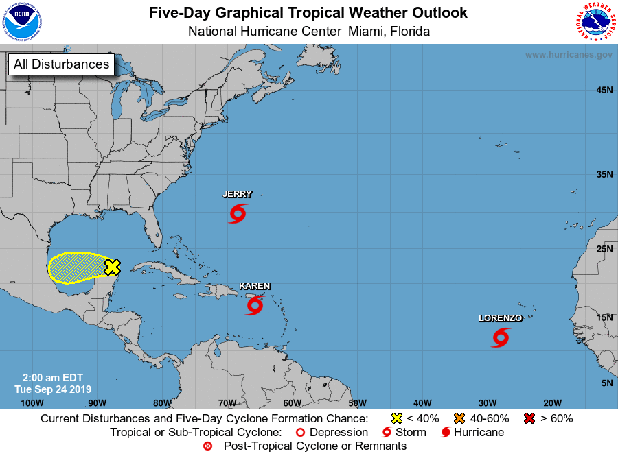
The same goes for the Yellow blob in the near the Yucatan Peninsula that the National Hurricane Center gives a 20 percent chance of developing over the next five days. It is moving toward Mexico, unlikely to develop, and should not have much, if any effect on Texas’ weather this week.
Finally, we have reached September 24th. After this date, the odds of a hurricane striking Texas are very low—historically about 2 percent. Often, on this date, I will boldly declare that the state’s hurricane season is over. However, given that Houston has yet to receive a real cold front this year, I’m not ready to declare Texas’ hurricane season quite at an end—but we’re close folks.
Hey Eric!
I suppose it’s just the time of year, but the mornings have been pleasant (in the absence of a cool front of course). Is it simply the sun’s angle in preventing a stifling atmosphere?
Finally, this notable lack of a front so far is probably due to many reasons, but one of the big ones I’ve seen is the jet stream dipping over the west and arching way over the east?
Thanks, as always!
Thanks, Eric, for the strong statement regarding Karen. It caused a lot of anxiety on “weather Twitter” this weekend. I too count on passing Sept 24 to “traditionally” end our hurricane season, but also know that a cool front has usually passed by today. Fingers crossed!
Thanks guys. Sorry…but still could use a few rain filled days on the West side. Definitely looks like the tropics won’t be of any concern which is welcome news for most. We’ve received .77 inches for September which continues the very dry streak we’ve had this Summer. If we don’t get some moisture soon and the Fall/Winter is somehow below normal…this will not bode well.
Front or no front- it’s NICE outside! A two wheel day!
Loving this weather. Great for working outside, especially in the shade in the evenings!
HI Eric and Matt – great job as always. There was a certain local news station showing model runs of Karen coming into the gulf I believe solely for the purpose of ratings. It is totally irresponsible as no discussion was made about the likelihood of such an event. I”ll admit that it did cause me to look at the Euro – but even that was clean. There really needs to be a commitment by those groups to either state those runs withing the proper context or just be quiet as it just causes unwarranted stress to people.
If we are talking about the same station, I’ve been incredibly disappointed since their leadership changed.
Some cold would be nice!!! Cold cold cold!!!
Think the air will be dry enough to finally allow my car to dry out?
I like your use of the word “climatologically”. It’s like dermatologically, but obviously different.
Also-who do we talk to about getting Marco and Polo added to the 7 year rotation list of names. It would be pretty entertaining to have Marco moving his way across the Atlantic, with Polo following along after him. Thanks for being the most useful thing I read in the internet every day.
Sorry, that is only possible if one of those names is male and the other is female. But yes it would be amazing.
How about Paola? That’s close.
Given the non-sequiturs, I believe you are replying to the wrong post.
Try http://www.spacecadetweather.com ?
Think maybe the top might come down on the old convertible today!! Sounds like a good day for it…. as long as I keep the A/C on too!
Hi Eric,
I have an unorthodox question regarding TS Karen. I see its Left Hand Turn forecast this weekend and I have plans visiting Turks & Caicos next weekend Oct 5. What are your thoughts regarding impact there?
I’m really considering change of plan.
Thank in advance for reply. Cheers.