Houston enjoyed a sunny day on Tuesday, and we’ve got a couple of more to go before some rain chances return this weekend. But don’t worry, we’re not expecting anything too extreme.
Wednesday
With high pressure in place, we anticipate another partly to mostly sunny day today, with highs touching 90 degrees for many parts of the region. Some areas west and northwest of Houston may even reach highs in the mid-90s, which is pretty extreme for late September, even in Texas. Normal highs for late September are the upper 80s. Rain chances are near zero.
Thursday
This should be a day similar to Wednesday, with hot conditions and rain chances likely 10 percent or less. Summer marches onward, it seems.
Friday, Saturday, and Sunday
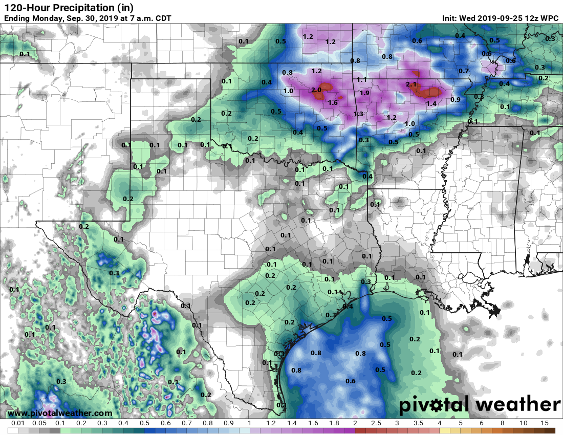
The pattern changes, subtly at least, this weekend. High pressure will retreat eastward, opening up Texas to more of a southerly flow of moisture. This will increase rain chances, and introduce the possibility of thunderstorms. But for the most part, we expect these storms to pop up, die out, and move on. Overall accumulations for almost everyone should be one-half inch or rain, or less, although a few storms may become fairly intense for a time. Rain chances on any individual day should be less than 50 percent. And skies, for the most part, should be sunny. Highs will be around 90 degrees.

Next week
Rinse, and repeat? As high pressure builds back over the region, much of next week appears likely to bring highs of around 90 degrees, with mostly sunny skies.
We’re still desperately seeking a cold front—does anyone know where we can place a want ad for such a thing?—and the forecast models are still flirting with something in the October 4-6 time frame. This remains a good while into the future, so we’re far from certain that’s when the region’s first real front will make it through.
The tropics
As one would expect for late September, the Atlantic tropics are hopping, with three named systems and the potential for more development. However, right now we just don’t see any significant threats to the Texas coast.
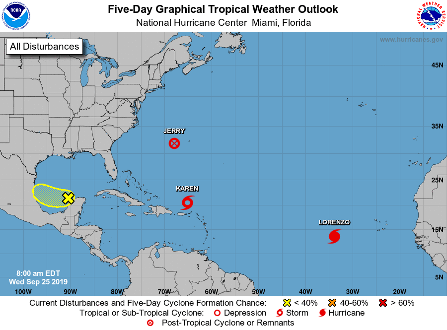
The much ballyhooed Tropical Storm Karen is moving north, but beyond that there’s not much clarity about what is going to happen. It may strengthen in five days, or it may dissipate. It may spiral around for awhile, or it may turn west. There remains a very small chance—call it 5 percent or less—that some remnant or version of Karen wanders across Florida into the eastern Gulf of Mexico in about 7-10 days. There is virtually no chance this would threaten Texas; and this is so far away, and so remote a possibility, it’s not something anyone local should be worried about.
As for Texas overall, until we get our first real cold front, we can’t preclude tropical activity for the next week or two in the state, but we’re simply not concerned about any specific threats.
Good morning! Wonderful job as always keeping us informed.
Thanks for your calm and to the point info.
Eric, I truly enjoy your sense of humor. I thought you were going to say “Sunny, with a chance of meatballs!”” Also love the idea of placing an ad for a cold front, “hot Texas city seeks cool breeze…” 🙂
Karen is being the internet karen meme it seems
Hey Canada! It’s hot. Send cold front. Thanks – Texas.
Eric,
What’s the word on drought conditions in Houston and Texas? We still need rain on the west side.
The US Drought Monitor map gets released on Thursdays at https://droughtmonitor.unl.edu/
Place the “Cold Front Want Ad” in the Fairbanks Daily News-Miner.
Overnight lows in the 30s. 10 day forecast at https://weather.com/weather/tenday/l/Fairbanks+AK+USAK0083:1:US
I’m sure our friends to the north would appreciate getting rid of some cold temps before WINTER really sets in and they get -20 F on a regular basis, quite a few days as the “high”
It’s a top-down kind of day!!! Of course the A/C is still blasting, but what the hey!
Does Lorenzo look like it will come here?
According to the site that they get their spaghetti plots from, it looks like it’s heading for Europe. https://www.weathernerds.org/tc_guidance/storm.html?tcid=AL13
Fall came out and saw its shadow. 6 more weeks of summer for Houston.