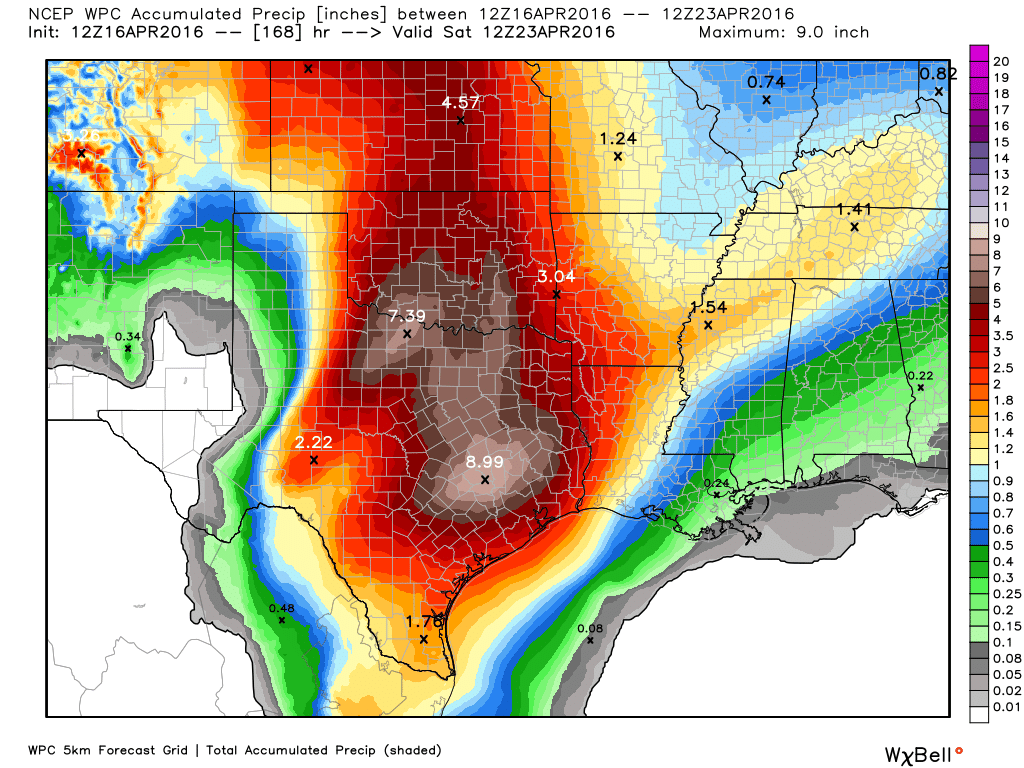
Here’s the latest on storms likely to bring heavy rain to Houston during the period of Sunday night through Tuesday.
TODAY
It’s cloudy and breezy this morning, and we’re going to see more of the same throughout the day. Winds should increase to the point today where we see gusts up to 25mph, and those southeasterly winds will bring lots of atmospheric moisture inland. Highs should reach into the upper 70s today and there will be a slight chance of light rain later today and tonight.
SUNDAY
Sunday will start out a lot like today, mostly cloudy, breezy and with similar temperatures. However a potent upper-level low pressure system will move into west Texas and should bring heavy showers and thunderstorms over central Texas, from Austin to Dallas, during the middle part of the day. Light to moderate rain will be possible in Houston during the afternoon and evening hours, but the potential for heavy rain really does not arrive until Sunday evening or during the overnight hours. For the most part travel on Sunday, during the day, should not be affected in the Houston region.
MONDAY
Some flooding is possible Monday morning, with the potential for heavy rain during the overnight hours on Sunday. However it now appears the best chance of strong showers and thunderstorms, and potential flooding, will come later on Monday and Monday night. In addition to ample moisture flowing off the Gulf of Mexico and the upper-level low pressure system, there will be divergent winds in the upper atmosphere that really force moisture at the surface to rise. This does not guarantee rainfall, but it does tell us that nearly all the conditions needed to produce very heavy rains will be in place.

My best guess for this event is widespread rain totals of 3 to 8 inches, with some isolated areas seeing a total of 10 inches or more. Because this air mass is warm and so moist, it will bring the potential for high hourly rainfall rates. Needless to say where the most intense rains occur, flooding is likely. The National Weather Service has indicated it will have to issue at least a flash flood watch. In any case, we cannot predict in advance where these bullseyes will be; they might occur over northeast Harris County, southern Brazoria County, or your neighborhood.
Although severe weather is possible with these heavy rains, such as damaging winds I’d rate the chances of hail as fairly low. The biggest threat is simply heavy rainfall.
TUESDAY
Heavy rains will continue into Tuesday morning, but we should begin to see some clearing out of storms by the middle of the day. A chance for lighter, shorter-lived showers and thunderstorms will linger for most of the rest of the work week.
Note that with the potential for very heavy rains over central Texas we’ll also need to be concerned about flooding along the Brazos, Colorado, and Navasota river basins into the middle of next week as this water moves downstream.