Stepping outside one can feel the moisture in the air, and it most definitely augurs what is to come—heavy rain. So let’s discuss that.
TODAY
Strong winds from the southeast have done their work, increasing atmospheric moisture levels over the region. They’ve also led to a Coastal Flood Warning from the National Weather Service, pushing seas 2-3 feet above normal and flooding low-lying areas. The warning remains in effect through 1 p.m. on Monday.
Large scale features are still coming together for very heavy rains across parts of the eastern half of Texas today, Monday and Tuesday. There are near-record high levels of atmospheric moisture, a potent-upper level feature, and an inflow of moisture from the Gulf of Mexico to recharge the moisture with atmosphere. None of these large-scale patterns will tell us exactly where the heaviest rains will fall, however, as that will be due to more localized features like the locations of slow-moving boundaries related to individual storms. I write all of that to say this: There is the potential for very heavy rain, but we can’t say exactly where the storms will bomb out.
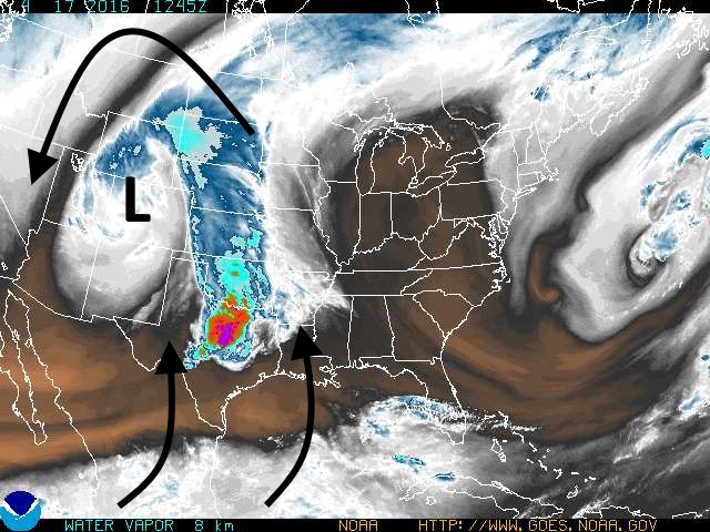
As for today, in the greater Houston region, I don’t expect to see much more than light to moderate rain and a few isolated thunderstorms through the daylight hours. We’ll continue to see strong southeasterly winds, and highs near 80 degrees. I do not see the threat of thunderstorms increasing over most of Houston—with the possible exception of areas well to the northwest, such as College Station—until this evening at the earliest.
MONDAY
At some point the bulk of a heavy thunderstorm system developing over central Texas today will move into the Houston metro area, bringing heavy rain with it. I’d peg this for sometime around after midnight on Sunday and sunrise on Monday, but the timing is pretty uncertain. This has the potential to cause problems on Monday morning, potentially during the commute. In any case, definitely worth checking a forecast before you head out the door. I will try to post something by 6 a.m. CDT.
It is possible there will be a break in the heavy rain and thunderstorms between mid-morning and the early afternoon hours, but in any case I think the timing for the heaviest rain will come later on Monday and Monday night. This is when atmospheric moisture levels will be at their highest, and there will be the greatest chance for very high hourly rainfall rates.
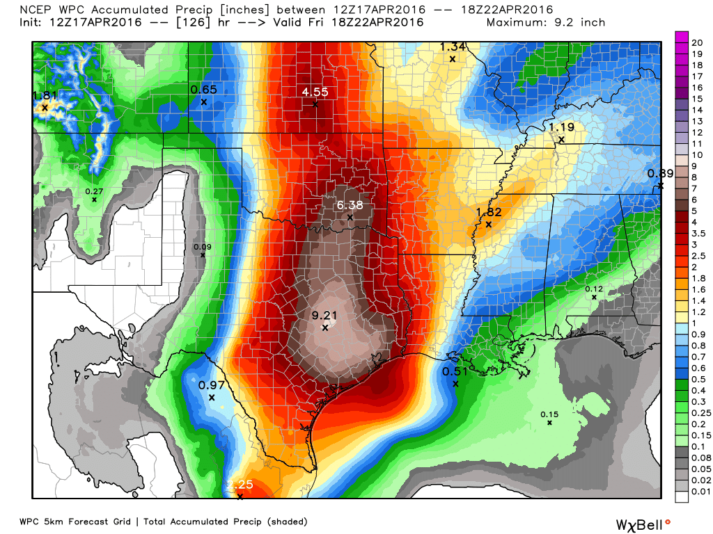
There is no reliable prediction for how much rainfall we are going to get. Not only are the forecast models scattered all over the place; this kind of event, with an upper-level low and very high atmospheric moisture levels, is dependent upon largely unpredictable localized features that really drive rainfall. Best guess is that most areas see 3 to 10 inches of rain during the Sunday through Tuesday period. But some parts of the greater Houston area may well see considerably more than 10 or 12 inches of rainfall.
If there’s any good news it is this: The threat of severe weather, other than flooding, appears to be low over Houston. The atmosphere just doesn’t seem all that favorable for producing hail or tornadoes. Can’t rule them out, but I’d bet against them.
In regard to flooding, obviously it will occur where rains are heaviest. But I’m also concerned about major rivers in the area, particularly the Brazos River, which likely will see very heavy upstream rainfall. People living along the Brazos watershed should definitely pay close attention to water levels this week.
TUESDAY
Heavy rain chances will persist through much of the day Tuesday before this event begins winding down during the afternoon or evening hours.
WEDNESDAY and BEYOND
Intermittent rain showers will remain possible through Friday, exacerbating any flooding problems that occur during the next three days.
It looks like the color of rain intensity has shifted south, compared to an earlier map.
Yes, it has.
Did you see Dr. Gray of Colorado State passed away at age 86? He unfortunately was somewhat controversial later in life (in weather circles) but a very important meteorologist nonetheless. RIP.
I did, Mark. I talked to him on the phone half a dozen times and met him at the National Hurricane Conference 3 or 4 times. A real pioneer and his students are scattered all over tropical meteorology today. You are correct about his controversy creating views later in life, but a legend in hurricane science nonetheless.
Interesting that both William Gray and Neil Frank, two giants of the hurricane forecasting world, do not believe in human-caused global warming.
Anyway…I told my son that his Monday night baseball game will probably be rained out.
Hi Eric, does it look like the up to 10″ will come in a short period of time like Memorial Day last year or more spread over the Sunday-Tuesday period?
Thanks again for all your work.
Yes, rainfall rates in some locations could be very high, like during Memorial Day. But the heaviest rain could well occur over far less populated an area, making it seem less impactful for more people.
So I guess it’s a near certainty that son’s JV baseball game is rained out for tomorrow (Sugar Land)?
Gotta ask-comparison to Memorial Day 2015? Too early to tell?
I think some select areas will see rainfall like that. But will it be in Brazoria, Montgomery, Walker or some other county? We can’t say that yet.
Thanks. As always, appreciate your response and candor.
Eric, some people in the comments section at the bottom of this article…
http://www.chron.com/news/houston-weather/articleComments/Heavy-rains-bring-potentional-flash-flooding-7253618.php
…said that they really do miss you.
I’m thankful to whoever provided a link to this site.