The much promised pattern change in Houston’s weather is finally at hand.
During the last couple of days a tropical system has completely soaked Louisiana, leading to flash flood emergencies across parts of the state, especially for parishes just north of, and along Interstate 10. Beginning later today Houston is going to see increasing amounts of moisture from this system move into the area, which should set the stage for several wet days.
How much?
It is going to be hard to nail down the particulars of when, exactly, the heaviest rain will come. But it’s safe to say, with a tropical air mass moving into place over the region, heavy rain will be possible most days beginning later today through Thursday or Friday. Not every location will get hit every day, but we should see mostly cloudy weather on most days. After five consecutive 100-degree days, and a 99-degree mark on Friday, we should see highs confined to the upper 80s to lower 90s most days.
Because Houston has been so dry during July and the first half of August, the region can handle quite a bit of rain—even 6 to 8 inches over several days would be manageable—before we start seeing flooding. The caveat here is that with tropical moisture in place, we will have the potential for very high rainfall rates that can cause some flash flooding. This is the biggest concern we’re going to have to watch for.
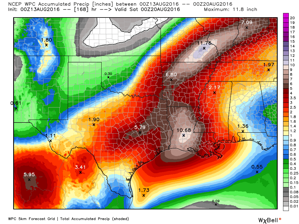
I think the most likely scenario is the region sees 4 to 6 inches of rain during the coming week, likely with higher totals on the eastern side of the region (i.e. east of Interstate 45). The best chance of rain may come later on Sunday and Monday. During heavy downpours this may cause some temporary street flooding, but it does not appear likely that we will see widespread flooding backing up into neighborhoods.
In any case, we’re now making the transition from hot and dry, to muggy and wet weather. In Houston, in summer, that means the potential for floods so that is something we’ll have to watch for.
Posted at 8:15am CT on Saturday by Eric
I, for one, am ready for rain after only .9″ of rain in 2 months! Eric, I am wondering if the system in Northern Mexico will merge with this Gulf low? Will they stay separate systems and what might all this mean for the Houston area?
As a weather neophyte, I am curious what you see that tells you we will have so much less rain from this system than did Louisiana.
Because the tropical low is going to move further inland, and is forecast to become less organized. We’re still going to see a lot of rain, but unlikely the 20+ inches that fell in some areas near Baton Rouge in less than about 24 hours.
Nice that this coincides with the first weekend of (preseason) football. Can it be that the end of our travail is in sight? Bring on that first Cold Front!