Houston’s on a hot streak and not just at the Olympics! Our streak of 100° days was extended to five on Thursday. We were able to do 6 in a row last summer, and we will come close to matching that streak today. The hot weather in Texas has lead to record energy demand across the state:
ERCOT hourly system #demand tops 71,000 MW for first time. Final prelim is 71,197 MW between 4 and 5 p.m. pic.twitter.com/Ylwel8Hh6H
— ERCOT (@ERCOT_ISO) August 11, 2016
While no serious weather records are being set with this heat, Texas still sets power records because of population & economic growth. While we should have another scorcher today, as Eric has been talking up this week, cooler temperatures and some good rain chances are coming back our way.
Today
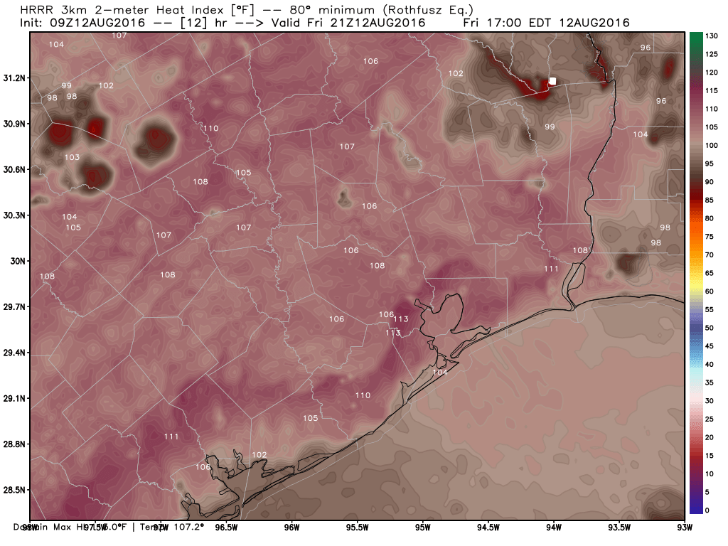
One more day of just a slight chance of a shower or storm, along with continued hot temperatures. A Heat Advisory is once again posted for all of Greater Houston, meaning heat indices will flirt with 110°. Actual temperatures this afternoon will make one more run for 100°, and it will continue to feel very unpleasant. The best chance for showers today will be near the coast and well north and east of the city, but as we saw yesterday, with a quick 1-2″ just outside the West Loop, any isolated shower could produce some heavy rains.
Weekend
Things begin to change this weekend. The dominant high pressure we’ve had for some time begins to break down, a cold front eases into North Texas, tropical moisture and some upper level energy from the West and Pacific moves into West Texas, and the pesky upper level low pressure system in the Southeast will drift west across Louisiana, closer to Houston.
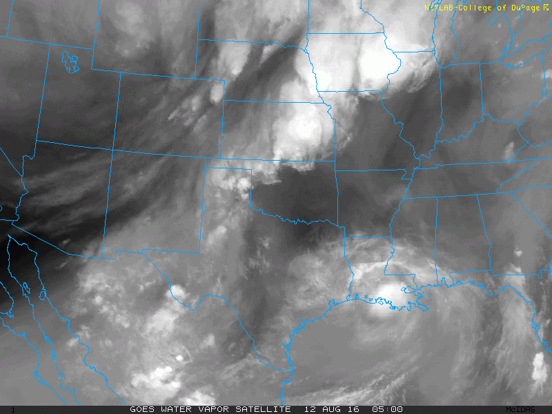
That is a lot of moving parts. Houston’s on the fringe, so we won’t see a major, widespread rain event unfold. We will however see numerous scattered thunderstorms, perhaps a bit more than usual for this time of year beginning tomorrow. If you have outdoor plans, I do think there’s a slight edge for Saturday than Sunday. Trends have been to gradually push Saturday drier in and around Houston, keeping most storms to our north. That said, there *will* be storms around Saturday, so keep that in mind. I’m just saying coverage of storms will be more widespread on Sunday. My hope is that it will be dry for the Dynamo match versus Toronto Saturday evening, but check the weather before game time.
Travelling this weekend? Here’s your forecast across Texas:
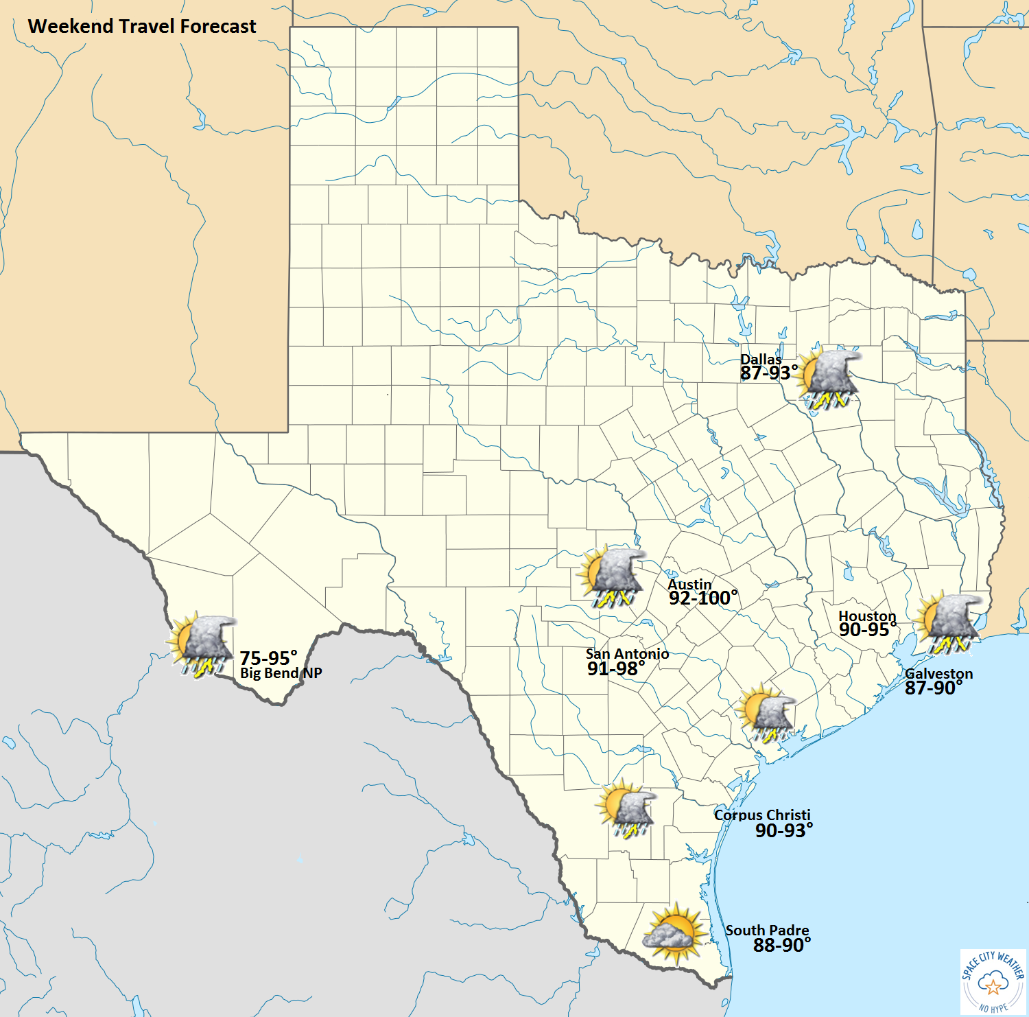
Just a note: If you’re traveling east from Houston into Louisiana, there are all kinds of problems this morning around Baton Rouge and New Orleans, with 6-10″+ of rain having fallen so far. Significant additional rain is likely in Central and Eastern Louisiana, so if you can delay travel to that region until later tomorrow or even Sunday, it would be advised.
Next Week
The individual pieces responsible for our uptick in rain will begin to lose their identities, leaving behind a bit of a messy pattern over Texas. This means there will be a daily focus for showers and thunderstorms each night near the coast, spreading inland during the daytimes. Most of us should see some rain on at least some days, but as is often the case with Houston’s weather, rain totals will be quite variable. Some folks may only see a couple tenths of an inch through the week, while others may see 3-4″ of rain in a day. Bottom line: Rain risks are higher than they have been, and if you do get rain, it may be heavy.
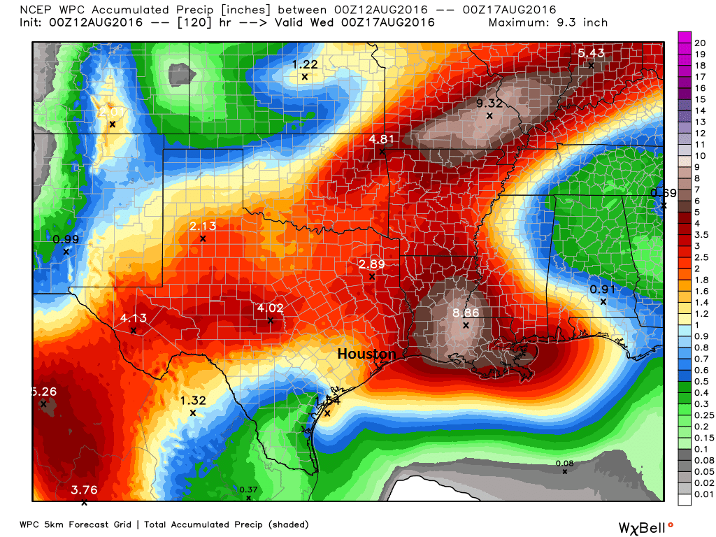
Temperatures will obviously struggle each day as a result, and we can likely say goodbye to the 100 degree heat for a while. Temperatures will still likely reach the 90° threshold by later next week, and there will be plenty of that Texas humidity. But it’s a start, right?
Posted at 6:35 AM Friday by Matt
I’ve officially had it with Houston summers! One is bad enough, but this is my 36th!
It’s time to look for a job in some place like Nashville or Charlotte or Denver (lots of luck, given my close ties to the chemical industry).
It’s not just the summers, it’s also the traffic and the construction (which makes the traffic worse for years and years) and now – thanks the Les Alexander – no hockey, either.
Time to move on…. and not just wait for retirement…
Dear Matt:
“Texas still sets power records because of population & economic growth.”
Will we eventually be facing rotating outages if the 100-degree days continue?
No, especially since the 100 degree days are not going to continue.
ERCOT has done a great job managing the situation. We have the best power grid in he nation, and as long as we continue to invest in it to meet growth, we shouldn’t have any problems in the future. Other parts of the nation aren’t so fortunate.