According to data from the National Weather Service, the month of August finished with an extraordinary average temperature of 91.0 degrees. This is nearly 6 degrees higher than the “normal” average temperature for the month of August in Houston, 85.2 degrees.
Moreover, it exceeded the city’s warmest month on record—any month in the last 150 years, mind you. This previous record temperature. 90.4 degrees, was set during the absolutely torrid month of August 2011. Temperatures this August were, by any measure, extreme and not-normal. The brown area in the graphic below shows the normal range of temperatures.
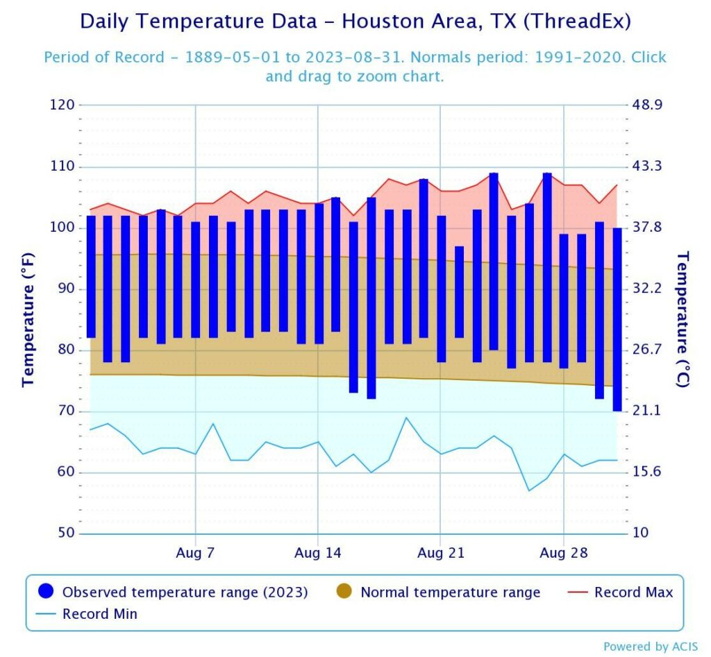
Along with this extreme heat, we recorded just 0.01 inch of rain during the month of August at the city’s official station, at Bush Intercontinental Airport. That’s one-hundredth of an inch. This was less rain than even the 0.09 inches recorded in August 2011, but second driest on record to a “trace” of rainfall recorded in 1927. The good news is that while our heat will continue, albeit at not as crazy levels, we do have some improving rain chances in the days ahead.
Friday
It’s not going to rain today, as we’re still under the influence of a weak front. This means we’re going to see sunny skies, with highs of around 100 degrees for much of the area. But we’re still enjoying some lower humidity this morning, and that should carry into the afternoon hours. However as light northeasterly winds turn easterly, humidity levels will rise. Lows tonight should drop into the upper 70s.
Saturday
This will be a sunny, hot, and somewhat humid day with highs near 100 degrees for the area. As moisture levels rise we’ll see an increasing chance of showers and thunderstorms near the coast. I’d say areas along and south of Interstate 10 have about a one-in-three chance of seeing a passing shower on Saturday. Skies will be mostly sunny, otherwise. Lows on Saturday night may briefly drop below 80 degrees.
Sunday and Labor Day
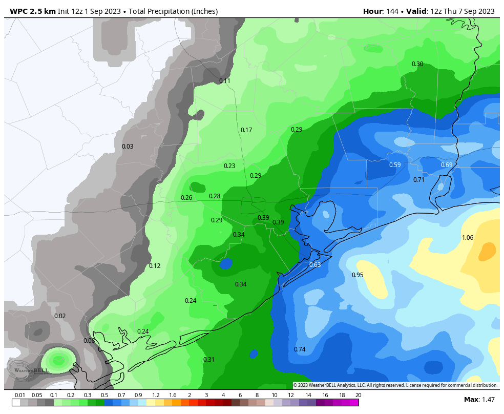
Here’s where the rain chances peak. Rainfall odds for much of the area are probably about 50 percent on Sunday, and 70 percent on Labor Day. Again, when it’s not raining (which should be most of the time), skies are going to be mostly sunny. So these will be passing showers as an upper-level low pressure system over Louisiana perturbs our atmosphere. The further one lives away from the coast, and the further west, the lower the rain chances and accumulations. So while I think coastal areas may end up with accumulations of about 0.5 inch, most areas further inland probably will receive less. Temperatures both days should be in the mid- to upper-90s, and moderated of course by passing showers.
Next week
Tuesday and Wednesday will both have a decent chance of rain showers, perhaps 40 percent each day, but then we’re probably going back to the upper 90s for the second half of next week with a hot and mostly rain-free pattern. We’ll probably remain mostly that way through the middle of September.
We’ll have an update for you on Labor Day morning about the area’s rain chances. Have a wonderful holiday weekend.


When you said “We’ll probably remain mostly that way through the middle of August.”
Hopefully, you meant Sept and not August of next year
Yikes! First the typo in the Eyewall calling Jose Juan! Now ending the SC post calling September August! No more Augusts please. Did someone start Labor Day weekend celebrations early?
But I was told it’s always hot in Houston in the summer and that this is normal!
Some of us use Celsius, most of us use Fahrenheit, but I’ve learned that some people here only have three degrees in their unit of temperature measurement: “cold,” “nice,” and “hot.”
If 90 means hot and 109 means hot then it’s always hot in Houston! No brain power necessary.
Yes, it’s always hot in Houston in the summer, and it’s normal.
I’m a lifetime native, and while it is hot here in the summer, it’s not like this normally. I don’t remember days in a row of 105F plus.
By definition, all time record heat is not normal.
Explain this to John above, because he doesn’t seem to get it. Same for the deniers that peppered this site earlier throughout the summer.
Thanks! You’re the best!! That second to the last paragraph, last sentence, you still had the horrific month of August in your mind. 😉
I would love to know what PWAT and PoP stands for. I am assuming it might have to do with rain chances but I am just curious. I guess Google would know but you will do a better explanation. So enjoy your app.
The acronyms, PWAT, stands for precipitable water and PoP, stands for probability of precipitation.
Pop is probability of precipitation – think “chance of rain.” Pwat is precipitable water – how wet the air is. If you condensed all the water in a given column of air down, how much is there?
I thought on September 1st you guys usually tell us when the first cold front happened last year to give us something to look forward to. I know it’s usually around late September last week or so.
Going by KIAH climatological data, on 9/14/22, we hit a daily min T of 66 deg F. This was a local data minimum as well with respect to days leading to and after, so almost assuredly was a front.
I thing the SCW folks like to use 65 deg F as a critical value. The first daily min T of <= 65 occurred at KIAH on 9/27/22, when the daily min fell to 59 deg F. This led to an eleven day stretch where daily min temps were <65 deg F.
I recall some very hot and dry summers (lived all my life in Houston), but these 109 temps and such prolonged mid 100’s truly took the cake. Hopefully we wont see these for another 10-20 or better, 100yrs.
10 days in August that tied the all time high temperature record for that day!
I wonder if there has ever been a month were more high temperature daily records were tied or broken in Houston.
I’m gladly waving “Goodbye, Felicia” to August. Not only was it hot but it is the only month without a holiday.
I welcome our September overlords with their promise of fall colors and cooler weather.
How is the data corrected to compensate for the urban heat island effect in Houston? In 2011 the population of the metro was 5.1 million, in 2023 the population was 6.7 million. An increase of 1.6 million people in 12 years, which means a substantial increase in urbanization, concrete, reduction in tree’s and etc. How is the record calibrated to compensate for the heat island effect from substantial urbanization especially on the north end, and actual changes in weather? I can tell a huge difference in temperatures by driving across the city, and IAH is not located in exactly the most rural area of the city.
They do not adjust for heat island effect. The best they can do is choose an area outside of the city. Airports work well because they are generally surrounded by miles of gov’t owned undeveloped property. If you’ve ever driven around IAH, especially the eastern side, you might feel lost in a forest. But even areas well outside of Houston experienced their hottest August on record, so I’m not sure how much an impact it had. To me, it’s the winter temps, especially nighttime lows, that have been impacted the most by heat island.
The official temperature location of record for Houston is IAH. If the weather people don’t adjust for the heat island effect, then the temperature records may just be a result of increased urbanization. Looking at the sat map for IAH doesn’t show much empty land and surrounded by 3 concrete freeways and FM 1960. If you go back in time with google maps, you see nothing but increased growth in the area, as has happened in all areas of Houston. Maybe we need to consider things that don’t increase the heat island effect and we can have our cooler summers back. Not accounting for all factors that increase temperature makes doesn’t change the temperature. But it does change what is causing the temperature to increase over time and what are the actions we should take. Not accounting for the heat island effect is a major flaw gap in the understanding and reporting on the area.
The data is from the weather station at IAH. Any “heat island effects” is local to the downtown area.
I live pretty “fur” from the coast, but those who live “further” from the coast will get less rain from me. That’s as “fur” as I will go in trying to explain the difference between “further” and “farther.”
I am hoping that rain won’t ruin the holiday weekend, as it often does.
After this dry, dry month I will take a Labor Day inside, watching the rain, over a 110 degree Labor Day BBQ 100%. No contest.
Yep. 110 is an ugly temperature, and Houston brushed close with it three times over the past week. Fortunate that the city remains under that number for the time being.
We need rain more than anyone needs a rain-free BBQ.
ummm no we need all the rain. I don’t care if the holiday is ruined
Jason, would I be correct in saying that you probably live in a condo and therefor don’t care about, trees, plants, foundations, wild life getting water, etc.?
It’s September. This isn’t the time to be thinking of fall and Halloween decorations and pumpkin spice. This is dangerous time of peak hurricane season. A killer ‘Cane is ready to huff and puff and blow your house down if given the opportunity.
Everyone here is aware of this months dangers. People just want some rain this weekend to happen.
With a couple of exceptions, the forecast is now showing 99 or 100 every day until at least the middle of the month, with the assumption that this will go on for the rest of the month. This is insane and pretty soon if this is going to be the trend from now on, Houston and this part of the country is going to become uninhabitable.
If the Labor Day rains can verify, that will assist in taking down forecasted temps (although whether or not the pattern remains overall dry/hot through the month is another story).
I said same thing in 2011. It’ll come around. We live on gulf coast, it’ll flood more than drought. It will cycle through.
Eric, do you think this summer was the “new normal”. If so, I am out of here.
For this to be a new normal, the average temp would have to go up several degrees, or we would have to be in a different climate zone. However, I wouldn’t be surprised if this is the new “normal really hot summer,” i.e. likely to happen every decade or two.
Many times I see the weather forecast change at or about I10. Is there something about this line that the weather is often different above this line? Is it merely coincidence? A line of convenience, a landmark everyone knows?
“The heat of autumn is different from the heat of summer. One ripens apples, the other turns them to cider.” – Jane Hirshfield
I am not Nostradamus but I will predict that that the last week of September and all of October will be below average. November is still to far out for my magic 8 ball…
We just need a really good hurricane to get the rain we need.
I agree with a number of others in the comments section; The Heat Island Effect is very localized and could be a factor for perhaps one or two weather stations in urban Houston. That said, the record breaking temperatures this summer were caused by a Heat Dome, High Pressure Ridge, Texas Death Ridge, whatever you want to call it…that extended hundreds of miles across Texas and at its peak even a thousand plus miles through the states of Oklahoma, Louisiana, Kansas, Nebraska, parts of Iowa, Missouri, etc…and even at one point to southern Minnesota!
The problem that alarms me the most is the DURATION of these summer heat waves. Sure, past heat waves have happened; there are examples from the 1930s, 1950s, and 1960s. But they were short-lived compared to our current situation. The other VERY troubling factor involves back-to-back years with heat wave summers. I haven’t checked the records, but I am fairly certain that they are rare. Yet the summers of 2022 and 2023 stand as testament to how troubling these can be to the vegetation, wildlife habitats, and residents. Droughts are a third factor of concern. It is NOT always the case that you get both record temperatures AND severe drought in the same summer. Sometimes a heat wave is followed by a rainy period or the pattern is broken up by a series of tropical events or pulses. For example, August 2022 had a nice rainy factor to it. NOT so this year!!! A very dry August indeed! The drought will eventually succumb to some nice rains later this year, the sooner the better! Sorry to be so long winded, just a lot to think about these days.