Good morning and happy Labor Day. In honor of the holiday, this will be a fairly short post. After slight rain chances on Saturday and Sunday fizzled out, today offers our best hope of meaningful since July. The setup is pretty good, with the combination of ample moisture, daytime heating, and a fair amount of instability in the atmosphere. This is all being driven by an upper-level low pressure system to the north of our region.

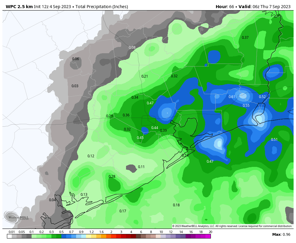
As of 7:30 am CT, we are already seeing numerous showers just to the east of our region, from Bolivar Peninsula over to Lake Charles, Louisiana. Over the next few hours, these showers should build westward, closer to the Houston area. But that is not a guarantee you will see rainfall. I would say that areas to the east of Interstate 45 have about a 60 percent chance of seeing showers or thunderstorms today, with areas to the west 40 percent or perhaps even less, especially areas further inland.
Rainfall amounts will vary widely. A few lucky locations may pick up 1 inch of rain or more, but for the most part it should be measured in a few tenths of an inch. Of course many locations will not see any rain. Storms that do form, generally, will move from south to north.
Highs today will depend on the extent of rainfall and cloud cover this afternoon. Areas east of Interstate 45 may max out in the lower 90s, whereas areas further west may reach the upper 90s.
I expect that Tuesday will be similar, in terms of the setup, although I would expect slightly less storm coverage during the afternoon hours. Wednesday, too, will carry at least a 20 or 30 percent chance of showers.
The period of Thursday through Sunday quite hot again, as high pressure builds over the region. We’ll probably see highs in the upper 90s, with mostly sunny skies. Some areas may very well reach 100 degrees again. I am cautiously optimistic that this period, Thursday through Sunday, may be our last real fling of triple digit weather for 2023. No guarantees, but after that the temperature outlook does start to look a bit better.
We’ll be back tomorrow with a full forecast. Please enjoy your holiday safely, responsibly, and, if you’re lucky, with a measure of liquid gold from the skies.


Thank you so much for posting on a holiday. Love reading your expert and amusing posts!
I saw a little rain in cypress…after 6+ weeks of NO RAIN. It’s gonna be a good week!
Dang, I didn’t get any in Copperfield, though there were dark clouds around.
Thanks for the update! We got .5” here in SE Katy area. So very thankful!
What is that little blue circle just below the loop that gets less rain, because that is wholly accurate. Is there a concrete barrier there? We had delicious rain clouds just outside that circle and the rain waved as it passed by but we had maybe a tenth of an inch, if that. And it’s a repeat phenomenon. No measurable rain in two months with a handful of almost rainfalls just like that.
Very good. I hope we see lots of meaningful.
This period quite hot. Sun spirit very angry. Need open window in teepee.
The summer without mosquitoes or the summer without mowing, not sure which title to choose.
I’m sorry, but I can’t help feeling that the phrase “liquid gold” is ill-chosen here.
Its a joke David, relax
When will heat dome die???