Happy Monday, everyone. There’s a lot to get to today, from a discussion of our recent windy conditions to warm Easter Sunday weather to the happy possibility that spring-like weather—we’re talking cool and dry nights—may not be done with us yet.
An extra windy spring?
Let’s start with the wind. After breezy northerly winds on Thursday and Friday of last week, the onshore flow returned with avengeance this weekend. On Sunday, wind gusts easily reached 40 to 45 mph and above in some locations. No fewer than three people e-mailed this weekend asking if Houston was having an abnormally windy spring. And I’ve wondered the same thing myself, so let’s investigate. If we look at “normal” winds over the last 30 years, we can see the the highest winds come during the months of February through May, with the peak in April. The average wind speed for April, in Houston, is 8.9 mph. In the chart below, the top row shows the average wind speed for each month, from January through December, in Houston.
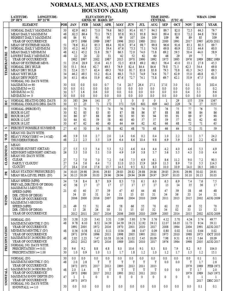
Now let’s look at the current year. In February, this year, the average wind speed was 8.7 mph, so a little bit above normal; in March it was 9.3 mph, a little bit more above normal; and so far in April, the average wind speed has been 9.7 mph, nearly 10 percent faster than normal. So by the most basic metric, yes, this spring has been windier than normal. And since spring is already typically the windiest season in Houston—when we often see sharp gradients between the warmer Gulf and colder plains—your perception that it’s quite blowy outside is justified.
Monday
Today will bring mostly cloudy skies and a continued southerly flow. The winds will not be as extreme as on Sunday, but I expect that much of the area will still see gusts in the range of 20 to 30 mph today, especially as we get toward late morning into early afternoon. Despite the clouds, highs will likely get into the mid, or possibly upper 80s today. Most likely, a capping inversion will prevent the development of showers and thunderstorms today (Edit: as of 7:30 am it looks like the cap has broken for central Houston. This is somewhat of a surprise, but I still don’t think storms will be too widespread later today). Lows tonight will probably drop to around 70 degrees in Houston.
Tuesday
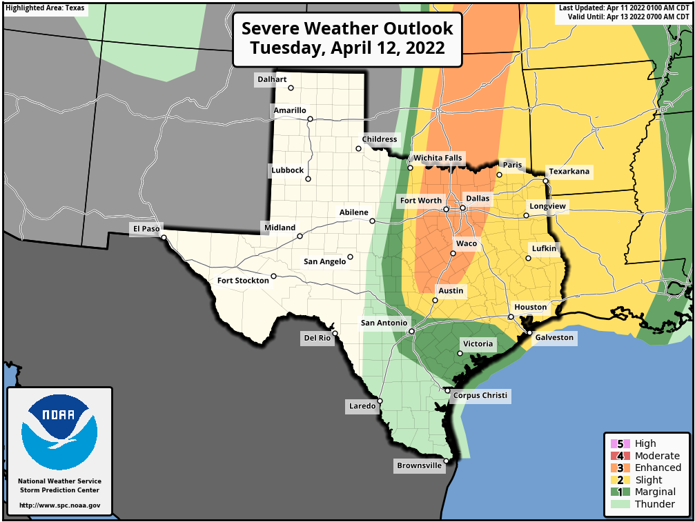
We’ll be on cap watch Tuesday, which means that we’ll be watching to see if the capping inversion breaks. An inversion simply means that there is warmer air aloft, which effectively prevents moisture at the surface from rising, and helping to fuel thunderstorms in the mid-levels of the atmosphere. This cap is likely to hold during the morning hours, but it could break later in the day. (Or, it could not). Should the cap break, we could see anything from heavy rainfall, to hail and damaging winds, to possibly even a few tornadoes. For now, NOAA’s Storm Prediction Center has placed nearly our entire region under a “slight risk” for severe weather on Tuesday and Tuesday night. Highs will otherwise be in the low 80s, with southerly winds at times gusting to about 25 mph.
Wednesday
A weak front will approach our region on Wednesday and may produce some additional shower and thunderstorm chances, although overall I’d put the percentage of precipitation at about 30 percent. This will be a partly sunny day, and pretty hot with highs likely reaching the upper 80s. The front should arrive later in the day or evening, cooling things down overnight, perhaps to around 60 degrees.
Thursday and Friday
Thursday should be partly sunny and pleasant, with a touch of drier and highs in the low 80s. Lows Thursday night will drop into the 60s, but humidity levels will already be rebounding by Friday, with another day in the 80s.
Saturday and Sunday
It looks like we’ll see a warm and partly to mostly sunny weekend. For now I’d peg highs in the mid- to possibly upper-80s on both Saturday and Sunday, with rain chances near zero, and noticeable humidity. My only concern is the potential for some decent southerly wind gusts, particularly on Easter Sunday. For now I’m thinking they won’t be too bad, but it’s something to watch for.
Next week
We’re still seven or eight days away, but right now the global forecast models indicate that a fairly strong, late-season cold front may push into the region next Monday or Tuesday, on April 18 or 19. It’s far enough out that we can’t be fully confident in this, but if it happens the region could see lows in the 50s, or possibly even 40s, for a couple of nights. This would be a rather nice cooldown for late April, so we’ll keep an eye on it for you. Have a great week, everyone.
Lows in the 50s next week (maybe)? Bring it on!!
Fairly steady rain falling, I-10 & Barker Cypress at around 7AM this morning.
It’s raining right now, with thunder and lightning, at 7:10 am in Spring Branch.
You mention a low likelihood for rain today. It’s been raining for last 30 min or so in Katy – for however long it lasts, can we expect it to reduce the pressure on the cap and lessen the severity of any weather tomorrow?
Me reading this as lightning and thunder and rain all are currently happening outside…. guess not about that inversion cap.
What about pollen?
I’ve been wondering the same thing about it being so windy!
Was just mentioning to my wife last night that this spring has felt more windy in Houston than those previous. We come from West Texas where the wind always blows, so we kind of lose track of it here unless we think about it. Thank you for confirming my hunch!
So no significant rain is what your saying?
Thanks for running the numbers on the wind. Interesting that the average is a) near 10 MPH and b) only slightly higher than normal when we’ve seemingly had really blustery days (Pooh!).
Mean wind speed is not the average speed. It is the midpoint of the lowest and highest speeds. Is there not better data than this chart available for historical comparison. These winds have been much more extreme than this midpoint comparison would suggest, in my opinion.
Median = midpoint, mean = average.
I think we will all miss the wind in a few months whenever its 98 degrees and sunny without the slightest bit of a breeze lol
Thank you for answering my question about the wind!