Good morning. We’re entering a summertime pattern where showers will be possible on most days, but rainfall by no means a certainty. For late July and August, our weather during the coming week will actually run on something of an even keel, with temperatures neither too hot or cold for this time of year, and neither a blistering drought nor flooding rainfall. We’ll take it.
Tuesday
Today will probably bring the best chance of widespread rain and heavy showers as an upper-level low pressure system passes slowly overhead toward the southwest. This should initiate showers during the late morning hours into the late afternoon or early evening. Areal coverage will probably be about 50 percent. As we saw on Monday, some of these storms should be pretty efficient lightning generators. Highs may rise into the low 90s this afternoon with partly sunny skies, and winds will be light out of the south. Overnight lows Tuesday night will be similar to those for the rest of the week—upper 70s for inland areas and lower 80s for the coast.
Wednesday
Wednesday will again bring a healthy chance of showers. However, with the upper-level low moving away we should see less organization in any storms that form, and probably fewer thunderstorms. Otherwise, skies will be partly sunny and highs in the low 90s.

Thursday and Friday
Toward the end of the week Houston will fall under the influence of high pressure, but we’ll be on the periphery of the high. Effectively, this means we can expect partly to mostly sunny skies, with highs in the low to mid-90s. These will be hot sunny days, with plenty of humidity, so take care outside. We can’t entirely rule out some scattered showers but for most of us these days will be dry.
Saturday and Sunday
The forecast for the weekend is not entirely clear, as we don’t have great confidence in the progression of a large area of low pressure moving across the central United States. This will push some kind of frontal boundary into northern Texas by Friday or so. While this “front” will not reach the Houston area, it could send some inclement weather our way in terms of showers and thunderstorms. Right now I’d say there’s about a 40 percent chance of rain on both weekend days, but that’s kind of a placeholder until we have a better handle on the overall pattern. When it’s not raining we can probably expect partly to mostly sunny skies, with highs in the mid-90s.
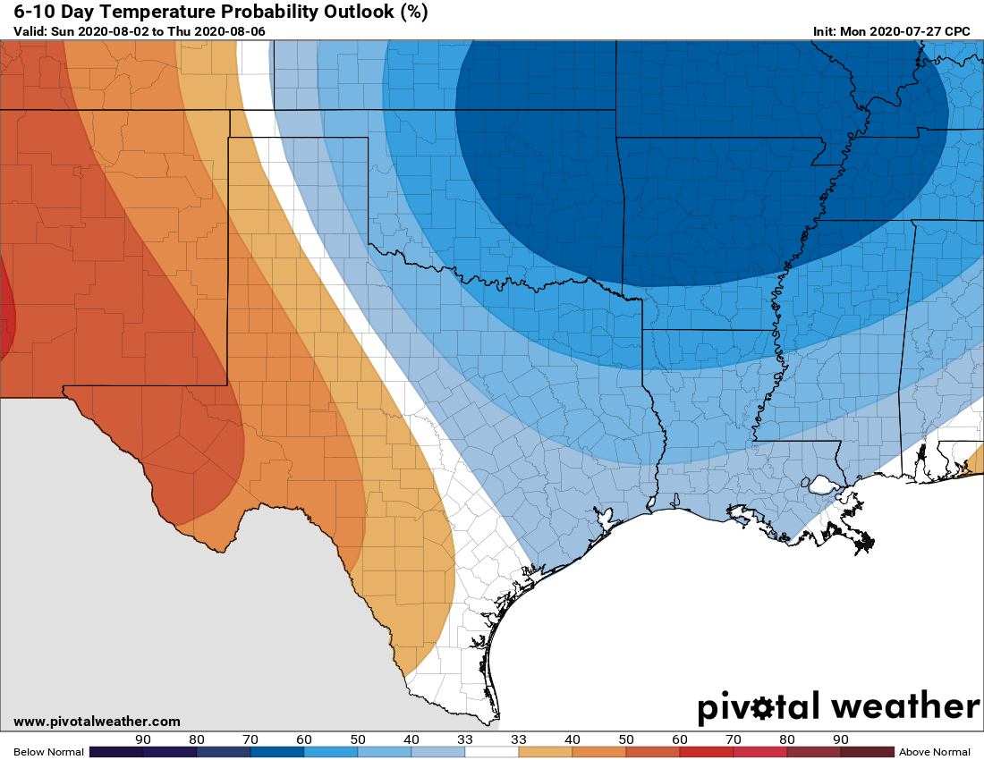
Next week
The first full week of August neither looks exceedingly hot nor exceedingly wet, but beyond that there’s not much sensible to say.
I’ll let Matt tackle more of this in his weekly tropics update later today, but it seems likely that we are done with tropical concerns and Texas for at least the next week or so. Which is good because with August on the horizon we’re entering the peak of the season.
Still getting used to this Houston thing whereby cloudy/cool weather is “the good weather.” 😉
I would stop at calling it good, rather preferring tolerable.
And, “tolerable” is only because of modern air conditioning. LOL!
When we are not getting our bi annual 500 year flood it’s always good.
Not to mention our annual 100 year floods.
I was surprised to hear thunder off to the southwest as I was trying to get to sleep. Now I understand.