Just what is happening around here? I take off a few days for a family reunion in a cooler climate, and return to sultry, face-melting summer heat and a forecast that includes 100-degree temperatures. I absolutely blame Matt for this and let me tell you, I’ll be writing a stern letter to the managing editor.
Alas, it’s only going to get hotter. And there remains no real confidence in when an end-date might be in sight. It high pressure domes for as far as the eye can see.

Wednesday
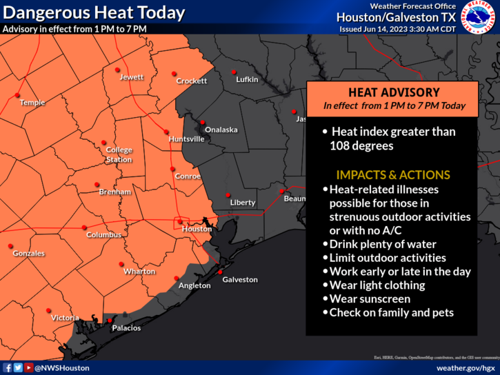
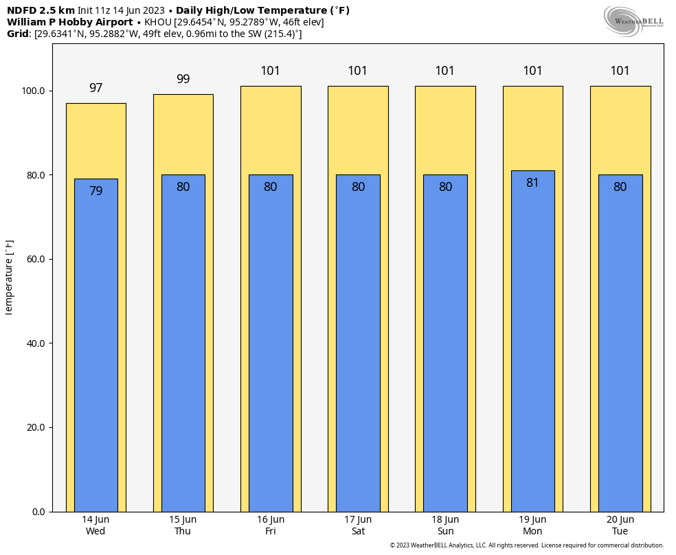
Temperatures remained confined to the mid-90s on Monday and Tuesday in most of Houston, but today we’re going to begin taking another step up. The central and western parts of the metro area will see highs in the mid- to upper-90s, and combined with the high humidity, this will bring dangerous heat to the area. The National Weather Service has issued a heat advisory for the time period from 1 pm to 7 pm CT today for all but the eastern part of our region. Winds will generally be light, at 5 to 10 mph, with slightly higher gusts. Lows tonight will only drop to around 80 degrees.
Thursday
Temperatures will pretty much be in the upper 90s to 100 degrees for the entire area, with the exception of the immediate coast. And if you’ve lived in Houston for more than 10 minutes, you probably don’t need to ask about the humidity.
Friday through Tuesday
We’re highly confident that these will be sunny and hot days, with most of the area reaching triple digits. This extreme heat will be driven by a high pressure system that will lead to sinking air, clear skies, and ideal conditions for daytime heating. Please take precautions with outdoor activities during the afternoon and early evening hours. Rain chances look to be 10 percent, or lower, each day.

Next Wednesday and beyond
The truth is, there is no concrete sign that high pressure will abate during the second half of next week, so the most likely forecast is one of continued high heat and very low rain chances. Maybe some slight relief will arrive as we get toward next weekend. We’ll see.


🙂 Well, wait a minute, Eric. Matt may have brought this upon it, but YOU were supposed to bring some cooler air back from your trip to “cooler climes.” Will you write the Managing Editor about THAT as well? 🙂
Thanks for making me laugh even though we are facing some hot temps!!! You BETTER take to the manager!!!
Wait, it’s not August yet….WTH.
This is the more subtle kick to the crotch before really getting walloped.
Does WTH mean What’s this (ridiculous) Heat?😂
The indoor season begins
I’m with STL Blues Fan: Eric should have brought us a “gift” of cooler air upon his return. But, still happy that Eric got some time away from the “face-melting” heat and some R&R.
There’s something not right about it being 82 degrees before 8 AM. Very. Not. Right.
With forecasts like this, I might unsubscribe to the newsletter! 🙂 Come on guys give me some hope we still have a long summer season to go! In all seriousness you guys are awesome… today Eric more so than Matt!
I’ll take the heat if you can tell the managing editor to keep hurricanes out of the forecast.
Oh, wow, ‘face-melting’ is absolutely right! Talk about an apt description! Love your posts & candor! Keep em coming 😀
🌬😎
You would think that I would be used to this after 38 years in Houston…but no.
Don’t we remember last year’s June and early July? We lost two chickens to heat stroke. It was really close to unbearable.
So much for “hype free” weather.
This is what we call summer time.
Fortunately, we’re already 1/4 of the way through summer, so the glass is not entirely empty.
Sadly, I don’t think saying there’s no end in sight to the heat is hype considering it’s currently el niño.
This ain’t normal Summer heat though Scott. Even for Houston- our normal high is 92 for now. The bigger problem is we’re running about 5-8 degrees above normal for night time lows as well so there’s no relief. 82 degrees before 8am in early to mid June is wild.
This isn’t normal in June. This is August weather.
I traveled from St Louis down to Houston yesterday and you are right….drove under the “dome”! Rained hard around Texarkana temperature around 70F then came here to breezy hot humid high 90s. Running City of Houston uggg water onto the property now (2-3 cpg!). Hoping the summer drought ain’t early or like last year. No model precipitation is showing thru June 24 which is latest for any confidence. Counting on the tropics or more pattern changes this summer.
As we settle into this hot and dry period, is there anywhere I can find precipitation maps for the rainfall in Houston through a certain period of time (like past week, 10 days, etc) so I can accurately try to figure out when to water my lawn?
You can see rainfall totals for various time periods, including for the past month at the various stations monitored by Harris County here: https://www.harriscountyfws.org/
I track Hobby which is 6” below normal currently. Go to weather.gov. There’s one for IAH as well. But I put at least 2” per week down. I would contend that inner loop is in a state of drought barring even the thunderstorms we’ve received because they have not been soakers. Except for 2021 which was normal rainfall….inner loop has been in a drought since 2019-2020 so I personally laugh when people complain here about the rain. They must not be trying to grow anything. And comments like “thank goodness no tropical activity”. We need rain storms from the Gulf because of the knock on effect of the hot Mexican desert plateau. Further East on the Gulf Coast rain is much more regular. The climate in NOLA is much more pleasant for example despite more potential for hurricanes. And the chances of a bullseye are minuscule…. of course not putting down risk and damage from a bullseye. I fear the climate change has made the western GC rather unbearable climate wise
I was mostly talking about the time between, and intensity of, rainstorms to water my lawn. It surely needs it very soon.
You can view rainfall activity and adjust timespans for the range you want here: harriscountyfws.org. If link doesn’t work, Google Harris County Flood Warning System.
Perfect! I totally forgot about that! Great website! Wish it had more color-maps but there should be enough points on the map to get a good estimate
Didn’t know about that one. I watch the bayous for flood info. It seems like you have to monitor each 24 hour period? Didn’t see a way for e.g. looking last week. But excellent tip!
I appreciated Matt’s deep dive into hurricane research on your severe weather blog this morning. I didn’t realize how much I miss juicy science talk since finishing my geoscience degree over a decade ago.
Ha! It’s so funny. I absolutely hate my life here. Every summer I wonder what am I doing with my life by continuing to exist here. It’s like living in an armpit in the swamp except with worse air quality. Enjoy.
Yep, Houston weather is unbearable for 6-8 months out of the year. AC home to AC car to AC destination. Literally don’t do anything outside during this period.
I will take heat over cold !
Everyone complains.
Some won’t agree but… it seems the last two if not three summers have featured an unreasonably hot June to be followed by a comparatively nice July/August. Let’s hope that’s the case
Is there a sense that this dome is here to stay like 2022 or is this one that has a better chance of movement by the end of the month/beginning of July?