Good morning. After a very soggy weekend, Houston is in store for more precipitation this week. There will be some locally heavy rains undoubtedly, but it’s my hope that the rain will be spread out far enough over the next four to five days that our bayous will have time to do their work, and we won’t see major, widespread flooding. Nevertheless it’s May, it’s storm season, so we certainly can’t be sure of that. Let’s discuss.
TODAY
An upper-level storm system is moving across the state, but it has remained to the south of the Houston metro area this morning, closer to Corpus Christi. Up to a foot of rain has fallen over parts of the Rockport, Port Aransas, and Corpus Christi areas over night. This was the southern scenario I discussed last night, which means Houston may potentially see less rain that than previously expected. There’s still some uncertainty, but I think as of right now the metro area is likely to see 1 to 3 inches of rain today, with higher amounts closer to the coast. Accordingly, Fort Bend, Brazoria and Galveston counties are under a flash flood watch this morning, but Harris County is not.
It’s still possible that very heavy rain will develop over central and northern Houston, but as of now it looks like the bulk of the rain will remain to the south. If that changes we’ll let you know. In any case, these storms will move off to the east by the afternoon or early evening hours, and I expect dry conditions tonight. Highs near 80 degrees.
TUESDAY and WEDNESDAY
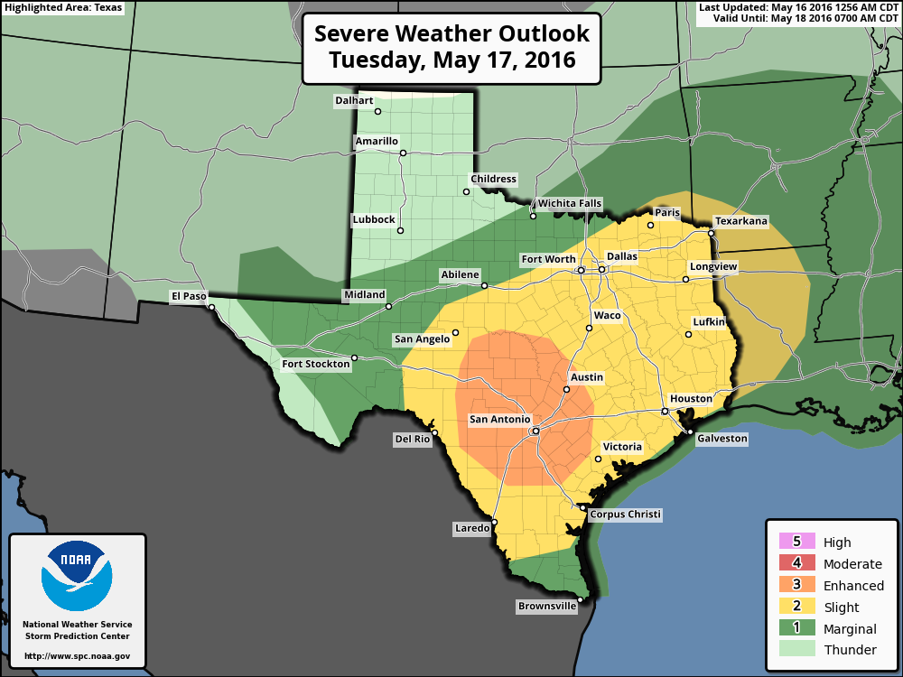
After fairly calm conditions Monday night and Tuesday morning we’re going to see a warm day, with highs likely in the upper 80s. This heating, combined with an approaching cool front, will produce a chance of severe weather later during the day and evening. Although conditions will be more favorable for severe weather to the west of the Houston metro area, the city could still see some heavy rains, damaging winds and hail.
Unfortunately, because this is May, the front is unlikely to march right off the coast. Rather, it will probably stall somewhere over Houston, or along the coast, creating conditions favorable for rain overnight Tuesday and through Wednesday morning. Some locally heavy rain is possible.
THURSDAY
Hate to say it, but conditions appear favorable for more rain—some of it potentially heavy—on Thursday. We’ll have to tease these details out as we get closer.
FRIDAY and SATURDAY
Finally some time on Friday, we may see an end to the almost daily, widespread rain showers. It looks like high pressure will try to establish itself over the region. This could, emphasis on could, lead to a partly sunny weekend with highs near or at 90 degrees. If Houston hasn’t sunk into the Gulf of Mexico by then it might be a decent beach weekend.
Posted at 6:55am CT on Monday by Eric Berger
Thanks for keeping us updated!
Maybe it would just be easier if we grew gills and fins.
Come to think of it, my toes were looking a little webbed in the shower this morning.
Houston weather….arrgh!
If this delays Houston summer another week, I’ll take it.
I’m kind of in the same boat. Figuratively — and almost literally.
good call, looks like it’s mainly south of the metro area. I hope there’s no flooding issues down there. Curious to see just how damp we get the rest of the week. Got long period of heavier rain in Atascocita yesterday that left water standing. I could use some dry out time.
Going to get some time to dry out later today and Tuesday morning. After that, we shall see…
This blog makes me wish I’d studied meteorology in college!