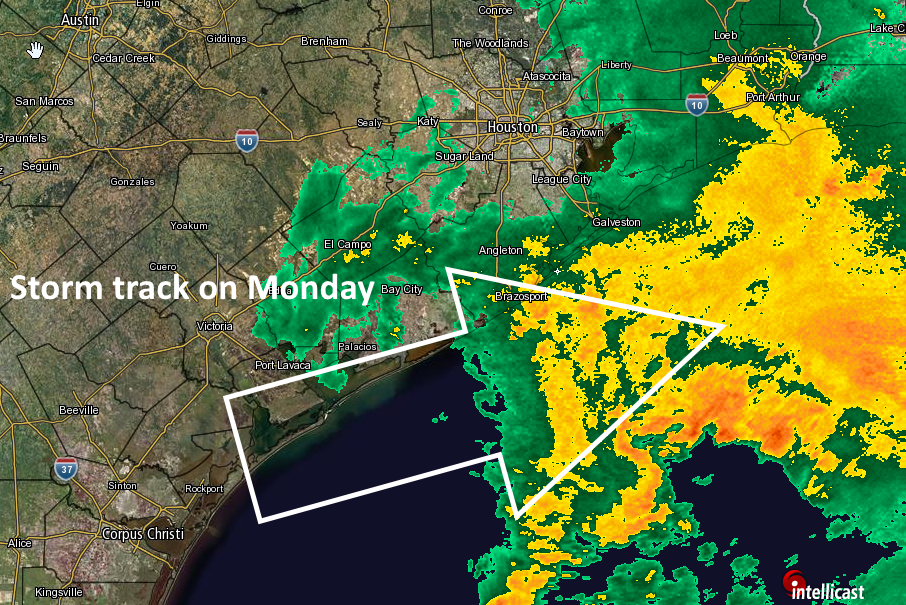
Well, the southern scenario did indeed play out today, with the bulk of the heavy rain remaining well to the south of the Houston metro area. Areas between Corpus Christi and Victoria received 8 to 12 inches of rain, but the city of Houston generally got 1 inch or less. This increases my confidence that we’re going to get out of this week without major, widespread flooding. But some trouble spots remain, and first up is Tuesday night.
As the rains move out of Houston later this afternoon we’re going to see a break in widespread rain. There may be a few pop-up showers, but I think the radar is going to remain pretty clear for the next 24 hours. But by mid-afternoon Tuesday, with enough daytime heating, we could see some seabreeze showers and thunderstorms develop across the area. For me the bigger concern is a cool front, an associated storm system that is going to roll over central Texas during the day. That area is under an “enhanced” threat of severe weather as a result. This system may potentially impact the Houston area after sunset on Tuesday.
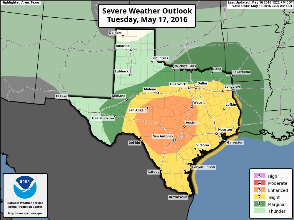
There is some question about whether the storm system will weaken as it approaches the upper Texas coast, including Houston. At this time, if I had to guess, I’d say Houston is probably not going to see too much serious rain or severe weather from this storm system. I’m betting on it weakening. However it is almost equally plausible that the storms spin back up as they near the moisture along the coast. Needless to say I am not confident in that forecast and we’re going to have to continue to watch for potentially severe weather Tuesday night and into Wednesday morning—the usual threats, locally heavy rain, damaging winds and hail.
For now just enjoy the break in the rain.
Posted at 2:35pm CT Monday by Eric Berger
Great! As usual, thanks for the update.
I’m trying to suppress asking “What time do we evacuate Katy,” because that joke isn’t funny when we’re closing highway 6 again for flooding.
But I’m so happy that I can refer to this blog when I want to know what’s up. Thank you for doing what you do.
Hi! Since your forecasts are the most accurate I have found, can I ask you about Friday? What is the rain and storm forecast for Friday? I’m in charge of my daughter’s school carnival and we are trying to prepare for the weather that day – set is 8-3 and event is 4-8. What do you think rain chances are that day?
Latest trend has been toward lower rain chances on Friday. So at this point I’d be cautiously optimistic.
“At this time, if I had to guess, I’d say Houston is probably not going to see too much serious rain or severe weather from this storm system. I’m betting on it weakening.”
So far all of the mesoscale models (the NAM group, that is) are in agreement with you about the weakening scenario, Eric. GFS isn’t saying much about the cool front, either. CMC is jumping on the coastal moisture spinup, but then the CMC is biased toward developing anything into a storm.
Right, Eric?
“For now just enjoy the break in the rain.”
Easy for you to say, Eric. Over the past 10 days I have suffered 10 power outages and 2 bouts of a backed up sewer, all courtesy of the “locally heavy rain, damaging winds and hail” you have just mentioned.
God, save me from the City of Houston!
Oh, I forgot to mention, Eric. You’re now saying there’s a GOOD chance we’ll have locally heavy rain, damaging winds and hail on Tuesday. A cheery thought!
Worrybug, when Houston is in a SLIGHT RISK area, that means that short lived and/or not (NOT!) widespread isolated intense storms possible. There might be one or two tornadoes, some reports of wind damage, hail and isolated heavy rain. From what SPC says, the higher risks of severe weather will be in Austin and San Antonio. Did I get it right, Mr. B?
Can the Tx. Tech forecast model be an outlier sometimes. It seems to be the only one that believes the thunderstorms in tomorrow’s front will not only regenerate but get really nasty, esp. in SE Houston. Does it overrule all the others?
Red alert, Eric! NAM 12 bullseye’s Houston on Thursday!