Steady, moderate to heavy rain showers are continuing to fall across the Houston metro area tonight. But even the most intense showers are only producing rain at a rate of about 1.25 inches an hour. That is within the capacity of most Houston roadways and bayous to handle.
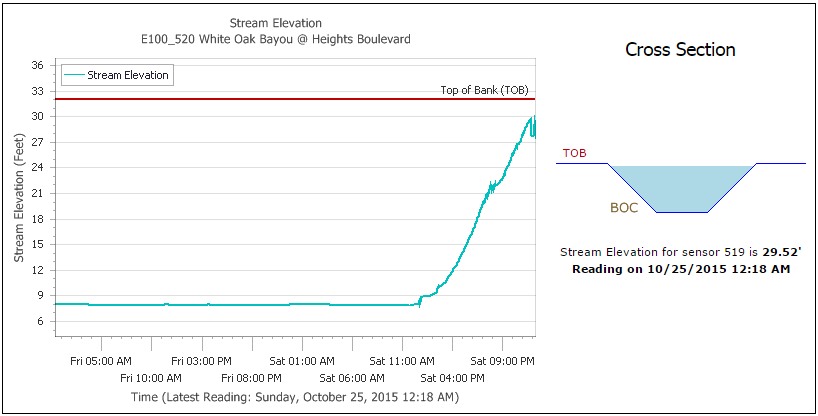
Emphasis on “most.” During the last hour some of the heaviest rain has fallen in central Houston, where areas like White Oak Bayou at Heights Boulevard has risen to within about 2.5 feet of the top of its banks. The bayou is likely to stray beyond its banks later this morning. A number of downtown streets may flood early Sunday morning.
It’s also true that there are already more than two dozen roadway closures in the region due to high water. But these are, for the most part, temporary closures of roads that often flood during heavy rains.
The reality is that this storm appeared capable of producing rainfall rates of 3 or even 4 inches per hour, which we have not seen so far today, nor do we seem likely to see on Sunday. This has allowed the region’s bayous to so far largely contain the heavy rain.
I’m striking a hopeful tone in this post because I think there’s a reasonable chance that Houston gets out of this storm with relatively minor damage considering the potential for flooding. My one concern is that these 1 to 1.5-inch hourly rain rates continue through Sunday morning, which would bring some parts of the city above 10 inches total. That would push some bayous past their banks.
In addition to White Oak Bayou, Harris County Flood Control District’s Jeff Lindner reports concern about the following bayous:
- Hunting Bayou: 3 ft from bankfull on upper portion of the watershed near Lockwood
- South Mayde Creek: 2.1 ft overbanks. Water is likely now starting to impact the south approaches on Greenhouse Rd
- Lower Cypress Creek: nearing bankfull at Cypresswood
- Halls Bayou: nearing 3.0 ft below bankfull at Jensen Dr
- Keegans Bayou: 1.5 ft below bankfull at Roark
Nevertheless, without the explosive rain rates, and with the rains coming to an end through the day on Sunday, we are unlikely to see widespread flooding of homes like Houston experienced during the Memorial Day weekend. That is very good news.
I will have an update at 2:30 or 3:00 a.m.
Posted at 12:30 a.m.
Thank you Eric! Hope you catch a break and get a chance to sleep tomorrow.
just want to say, you killed it today with the information and making it easily understandable! thanks for the hard work!
Thanks for all your hard work
You have replaced Jeff Masters. Good man – thanks!
Except that you really didn’t need to bring this storm to kick off your new website…
Jeff is awesome. I wouldn’t pretend to replace him. But I can bring a much tighter focus to the greater Houston area than he can.
Thanks for the info Eric!!!
How reliable are the predictions they post Here? http://water.weather.gov/ahps2/hydrograph.php?wfo=HGX&gage=BBST2
Pretty good.
Appreciate you staying up with us!
I admit I’m one of those who only reads you during severe weather events… because you’re awesome during severe weather events.
So imagine my dismay when I clicked over to the SciGuy blog this morning. Great to see that you’re still doing this. FWIW, I found you because of the SciGuy blog displaying your Twitter stream, which I clicked over to and then got the link here in one of your posts.
[note: If you haven’t already, probably a good idea to seed Houston discussion forums (citydata, HAIF, …?) with posts about SciGuy moving to his own website and linking here, to increase the chance that Google might show this place as one of the hits when people look up SciGuy. As I think about it, I’ll probably put up a post on the Rice sports message board, which is a little broader than just sports, and of course has an interest in weather specifically when it could affect games.]
If you could do this Joe, I’d much appreciate it.