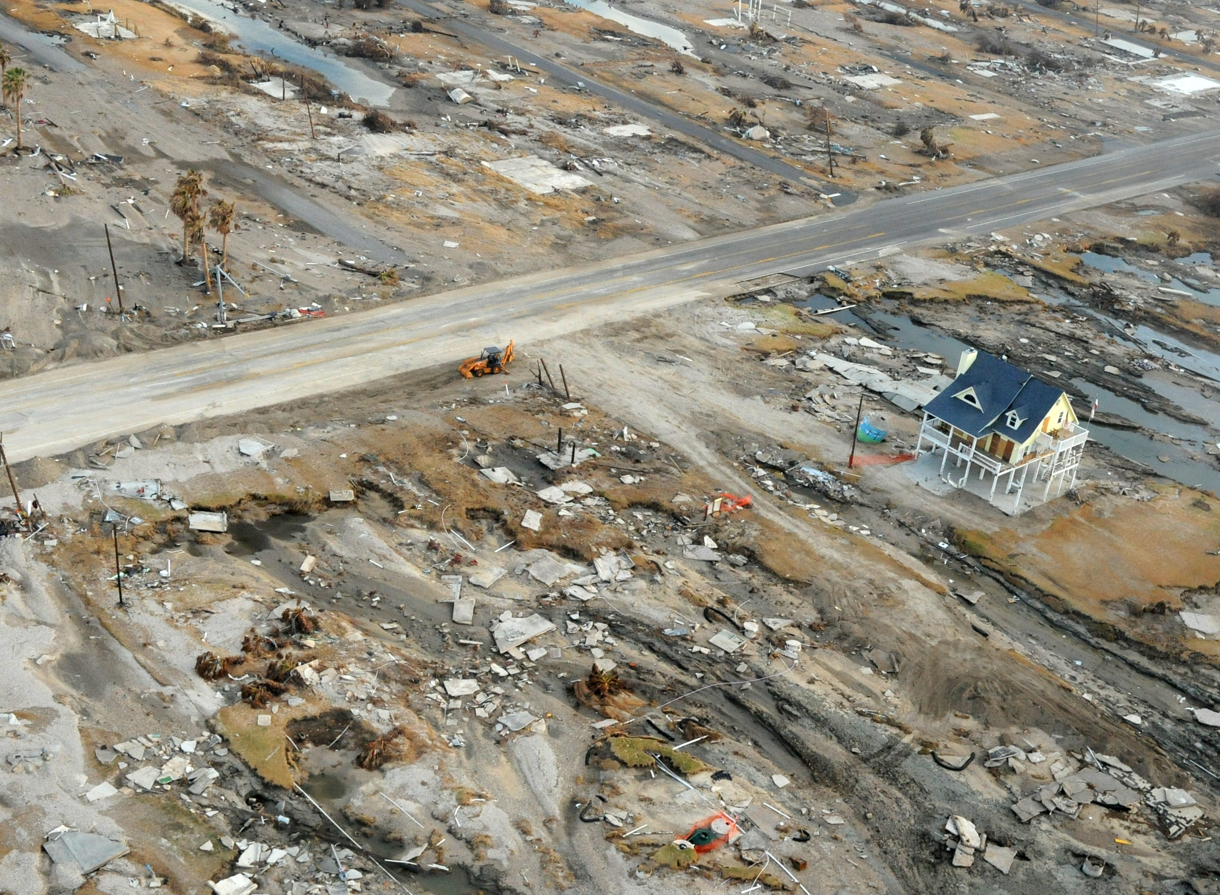
Anniversary Awareness: Ten years ago today we were watching the approach of Hurricane Ike, whose winds and storm surge pushed into Galveston on Friday, Sept. 12. I recall this time vividly, as I tried to grab a few hours of sleep in a darkened room in the Houston Chronicle‘s former downtown newsroom. Next door, at the Lancaster Hotel, a window blew out in my family’s room. I was powerless to help. Similar dramas played out across the region as the storm made a final landfall at 2:10am CT on Saturday morning. At the time, Ike ranked as the second costliest hurricane in U.S. history, behind only Katrina. It has since been bumped down to sixth, supplanted by Harvey, Maria, Sandy, and Irma. Unfortunately, the Houston region has yet to heed the lessons of Ike and enact any kind of surge barrier that would protect communities along Galveston Bay, expensive infrastructure along the Houston Ship Channel, or Galveston Island. The region remains highly vulnerable to a major storm surge event. On a personal note, a lot of the lessons I learned while covering Ike have made this site what it is today.
And now, the forecast. We’ll break this down into three parts: Rainfall potential for Wednesday and Thursday, Invest 95L and this weekend’s weather, and finally, a tropics update on the terribly threatening Hurricane Florence and, for now, a fading Tropical Storm Isaac.
Wednesday and Thursday
As anticipated, rain showers developed offshore early Wednesday morning and have begun moving inland into Matagorda, Brazoria, and Galveston counties. Although these storms are less intense and widespread that rains on Tuesday morning, they are nonetheless hitting some of the areas most affected by the earlier rains. Caution is urged on roadways in coastal counties and a Flash Flood Warning is in effect until 8:30 am CT. This pattern will likely more or less continue, with coastal areas picking up an additional 1-3 inches on Wednesday and Thursday, with higher isolated totals. Inland rainfall totals should, for the most part, be significantly less than this.

Invest 95L and the weekend
We’re continuing to track a tropical disturbance that has moved just north of the Yucatan Peninsula, and is now tracking toward the Texas coast. Fortunately, the system has continued to show no signs of development due to nearby wind shear. As this shear relaxes a bit over the next day or two, Invest 95L still has some time to strengthen before coming to the Texas coast some time on Friday. While it remains possible the system becomes a tropical storm, we see no reason right now to believe it becomes more than that, and we’re not convinced it develops at all.
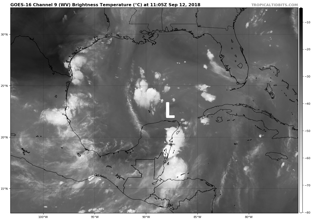
With no well defined center, it is hard to have too much that’s intelligent to say about the track. However, most guidance continues to indicate that this system will move toward the south Texas coast, likely moving inland between Brownsville and Corpus Christi. Along such a track we don’t have concerns about significant rainfall in the Houston area. As a rough guess, we’d say the region may pick up an additional 1-3 inches of rain from Friday through Sunday morning, again most likely along the coast. If this forecast changes, trust that we will inform you immediately.
Elsewhere in the tropics
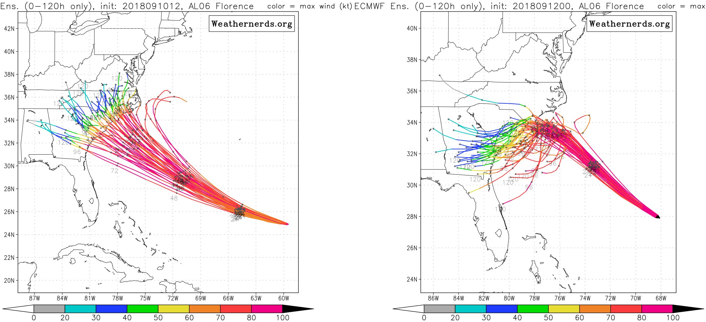
The forecast for Hurricane Florence continues to worsen. Although the storm has weakened slightly, the global models are now in general agreement that the hurricane will come very close to the Carolinas, or move just inland, and then make a rare if not unprecedented jog to the southwest. I wrote about Florence in more depth this morning for Ars Technica. The shift in model trends over the last 36 hours is pretty striking, and only worsens already heightened concerns about effects in the Carolinas, especially from inland flooding.
Conversely, Tropical Storm Isaac is weakening nicely as it nears the Caribbean Sea. Wind shear and dry air are doing work on the former hurricane. Isaac should weaken further as it tracks westward across the Caribbean this week, and may well become a remant low. We’ll continue to watch the system for a possible movement into the Gulf of Mexico next week, where it could regenerate. But overall, our concern with the system remains quite low for Texas. We advise you to not worry about it at this time.
Thanks for the update!
Thanks so much for all the info Eric!!
In the last few days i have Given your website to several friends who are totally frustrated with all the swirl of hype on TV so i tell Them to not worry and just read what Eric says!!❤️❤️
Thanks so much Rebecca!
Ditto!
Same here. Posted a recommendation on Facebook with a link for friends to follow.
Great update and I hope it keeps everyone callm.
As always, thank you for clear and concise information with out the hype. I started following you since the ramp-up before Ike (and the beginning of evacuation concerns for Katy 😂). And have told all I know that you guys are the source to trust for Houston weather.
Thank you guys for all you do!
Actually, Katy concerns go back to Katrina and Rita.
Jim, you are right. I live in a coastal community on Galveston Bay and it took 7 hours just to get to my sister’s house in Copperfield (my final destination) because of the widespread panic. People on the coast just wanted to get out of harm’s way and if Rita had not turned we might have had a big problem in Houston. Cars were grid locked on the highways–mostly because TV weather personalities were urging people that were inland to evacuate at the cost of coastal communities.
Thank you for great and hype free information. I did not know about this site during Ike. We had just moved to Kemah one month prior to Ike and had all the things still in boxes. had to evacuate with three elementary school kids. We lost everything and did not even know what everything was since it was all still in boxes. We rebuilt and have stayed on. Water is beautiful and serene most of the days. But when it is stormy, it is scary. I dont know if I will stay put or evacuate next time. Hope we will not have another hurricane for a long time.
Having a good heavy rain around Ellington as I write.
PlEaSe MaKe It StOp…….
Your Ars Technica article is #1 on Google News again Eric. Seems like they should do more weather-related stories.
Heh, yeah, Eric pointed that out in slack. It’s definitely providing Ars a bit of a traffic spike.
Is there a SCW slack channel?
No, but I’m considering adding a self-hosted Discourse forum so everyone has a place to congregate and talk. Talking that through with Eric to determine if it’s the best course of action. (I already maintain another Discourse forum on this server for my own site, so it’s not that much additional overhead.)
You don’t know how much it means to me to have accurate, honest, and hype-free weather information. I appreciate your reports to no end. Thank you.
Hard to believe that Ike was a decade ago. We left and we were lucky as our house only had minor damage. But I learned a lesson. We came home because our neighbors had said our neighborhood and our home were basically OK. I forgot about the infrastructure: gas stations, grocery stores, etc. Next time, I’ll come back alone to assess the local situation and then decide whether or not to bring the rest of the family home. It was difficult finding gas and food. Our local grocery stores were amazingly open but only for a few hours and they quickly ran out of everything. Getting gas was a hit or miss affair. Although our house was OK, if we can’t get food and gas, it isn’t worth coming back.
Thanks as always for the detailed yet fairly concise updates.
Always enjoy your posts! We have a trip to the Cayman Islands scheduled next Thursday…. trying to understand Isaacs potential impact!
Ike was our welcome to TX. We had moved down here about a month or so earlier. I stayed up until we lost power around 2am and woke up to the sound of shingles. Blew all the shingles off the front of our new house.
I want to change my birthday (9/12). It always seems that the worst weather is this day.
I’ve found “the third Saturday in April” to be a much nicer date than my birth certificate birthday. 😉
Ike was my first, and last hurricane. I had never experienced a hurricane before and since everyone I knew was staying and Ike was “only a 2” I thought it would be okay. At the time I lived in the Heights and even there, it was definitely not okay. As long as I have wheels, or feet, I won’t stay for another. And yes, I left while Harvey was still hanging about in the Gulf. My house didn’t get flooded but while I do have some “survivor’s guilt” the experience from Ike trumps it 🙁
You guys always have Houston’s back. Thank you.
Any idea when brazoria county, Angleton, stops raining? My ranch has turned into one big lake. Thanks for the updates and the great site.
Thanks for your comments about the impact of Ike. I fell in the street the day after Ike and broke my right tibia/fibia. I lay on the ground several hours. Calls for an ambulance to take me to the hospital went unanswered. Neighbors comforted me the best they could. I couldn’t sit up. Finally, an EMS trained trained tree man came and splinted my leg. With the help of neighbors, I rolled onto a blanket ,several neighbors picked up the blanket and put me in the backseat of my car, and my husband was able to drive me to the hospital. The hospital operating rooms had been impacted by Ike and I needed to be moved to a hospital in Katy for my surgery, and then back to the original hospital for some recovery. We didn’t have electricity in our home for two weeks. It was tough….then came Harvey. The floodwaters came up to the front of the flower beds in front of our home. Rescue boats from all over the US and people’s kayaks launched from our side yard. I am grateful to God and all the angels He sent my way with hands and feet to support me through the hurricane traumas. We were blessed with an unflooded house, unlike so many around us. It effects one to go through a hurricane. Grateful for your good weather service that gives us fair warning. Thank you.
How much rain can Corpus Christi expect from Invest 95? Unfortunately we rented a condo there this weekend, and we’re trying to decide if it will be a complete wash out, or even worse, unsafe to travel there.
I’m supposed to be in Corpus this weekend as well, and trying to make the same decision. Our plan has been to drive down on Friday night and we don’t have any flexibility in that, so it’s really just a go/don’t go call at this point. Leaning towards “don’t go” since Friday night seems highly likely to include driving through a potential tropical storm or even “just” heavy rain.
My boss told me about this site. It’s such a stark difference from what you see on the news…honest, drama-free information. Thank you!
Eric & Matt, If the scenario is now looking more like a Harvey outcome with moisture being picked up and thrown onshore repeatedly will we see like in Harvey where right onshore there is dramatically less rainfall than just 15 miles inland? We live on Tiki Island (& this on the 10 year anniversary of Ike!) we had no flooding and the water never came close to going over the bulkheads but 15 miles in at Dickinson the water levels were almost the height that washed over Tiki (and quickly withdrew thankfully) during Ike.
If I remember correctly Harvey got knocked out by wind shear and was nearly forgotten before it came back to life in the Gulf. I’m hoping Isaac doesn’t do the same.
We don’t think it will.
If that was the case, it was never reported that way on this site. I just went back and looked at the reports from 8/16/17-8/23/17 and SCW was never as dismissive about Harvey.
From 8/1617:
“Tropical Storm Harvey formed yesterday, and this morning it is moving into the Caribbean islands with 40 mph winds. Over the next five days, Harvey should continue to slowly work across the Caribbean. It’s unlikely to strengthen much initially, but once in the Western Caribbean, it may have an opportunity to gather some intensity before it heads toward Honduras, Belize, or the Yucatan. A couple models show it gaining a little latitude late, but those are in the minority right now. So while a southerly track, away from Texas is favored here, we should still keep an eye on things as Harvey progresses westward.”
8/21/17
“At the same time moisture from the remnants of Tropical Storm Harvey (which has degenerated into an open wave, but will have moved into the Bay of Campeche by then) may spread into Texas.”
8/22/17
“As you may recall, Tropical Storm Harvey dissipated on Saturday as it moved westward across the Caribbean Sea. However its remnant storms have continued to move west, and this area of disturbed weather is now moving into the Yucatan Peninsula. Several key forecast models anticipate development of this system over the next two or three days into a depression, and then tropical storm, over the southern Gulf of Mexico. The National Hurricane Center rates this as 90 percent likely, and a couple of aircraft reconnaissance flights are planned for today to investigate.
We’re starting to become a bit concerned about undead Harvey for two reasons—it has the potential to produce a lot of rainfall, and the forecast tracks have been edging northward, from a final landfall along the central Mexican coast to now closer to south or central Texas. The latter scenario, especially, could produce a lot of rainfall for Texas, including Houston.”
Looking back on these posts, every post was very well thought out and, as it turned out, almost completely accurate. If there is something to know about Isaac, we will know about it here.
I was just researching this as well. Harvey was a remnant too, so precisely what is the difference now? Eric just stated “we don’t think it will”…..why not? Are conditions that different?
I have the exact same question, Arianda. I would love to understand what is different about Isaac, and 95L for that matter, that diminishes their potential to develop at warp speed when they hit the Gulf, as Harvey seemed to do.
This photo of Bolivar is so sad and such a poignant reminder of the devastation of Ike, lest we forget
Eric
Supposed to be spending this weekend in San Antonio. Likely to be a washout or too early to tell?
Thank you for the update.
Hello! I love following your site and no hype advice. I have moved to Tampa, Fl. Do you have some “no hype weather friends” I can follow down here?
Eric, I believe that the Army Corp of Engineers has set aside more than half of the many billions Congress recently provided them for post Harvey to build the Bolivar/Galveston protection you mentioned.
Hi Eric,
If you have addressed this in the past, please forgive. But, my husband and I were discussing why the “European models” carry such weight both with you and the Weather Channel? Seems like they are so far removed from the geographical implications of hurricanes, and we are so close, so what is it that makes theirs more reliable? Thanks and again, as others have said, thanks for being such a trustworthy resource!!
Laura McGrew
https://www.nbcphiladelphia.com/weather/stories/European-Weather-Model-National-Weather-Service-365163381.html
Thanks Eric
I don’t mind the rain. It keeps the temps low. Just curious, can we expect some “Autumn” like weather soon.
Why don’t these other areas have a levy and storm gates? Look at Freeport/Lake Jackson. They close the gates and keep the surge behind the levy to protect the majority of the community, not to mention Dow Chemical. They work and have worked over and over and over for decades.
So, sounds crazy to ask, but what are the chances of Florence making it to the gulf. Looks like a few of the stray models in the ensemble you show have it crossing Florida.
ABC saying cat 4 storms create waves 85 feet high. Is this for real?
I’ve been following your blog since Ike. So much helpful advice. I’ll certainly never forget Ike. I hunkered down Friday night in my bathroom with my heavily-pregnant wife. We got through the night, then the next day my wife went into labor. My daughter was born the following evening, at home, by candlelight (no power). It was quite an excitement for the neighborhood, and the neighbors all rallied and brought us food, ice, etc. We considered calling her “Ikea”, but decided against it but we’ll be having our own 10th anniversary celebration this week!
Really appreciate your insight, unlike all the talking heads on TV you don’t over sensationalize everything. The TV weather guys act like every bad weather event is there “SuperBowl” and the hype it as much as they can…you guys just give it to us straight and I like that.
Question Eric. Do you see any concern for a flight from Houston to Tampa, FL on Sunday? Must arrive in Tampa by Sunday evening. Any input is appreciated. Thank you!
Thanks Eric, bookmarked this site. Read your stuff on Ars all the time. Don’t know why I haven’t come over here before this.
Thanks Brett!