Last night saw some wild storms in parts of the area, especially southeast, south, and west of Houston. The storms did cause some damage, primarily west of Houston.
Vehicle on FM 2977 with power lines on it. Waiting for @CNPalerts pic.twitter.com/Ywwk0c0wr7
— FBCSO Texas (@FBCSO) June 7, 2019
You can click here for a rundown of storm reports. The real show for many of us came after the storms, with a true spectacle of light, color, and clouds.
Or here pic.twitter.com/fW90Dst2GU
— Maria (@mariatexan) June 7, 2019
To the the East is the rainbow signaling the pot of gold in downtown. To the West, that 😳. @TravisABC13 @mattlanza #houstonweather #houstonwx pic.twitter.com/Y7bKpa9cC8
— Sarah P. (@singingcakelady) June 7, 2019
@mattlanza check this double rainbow! #houwx pic.twitter.com/A6zoiakAPQ
— Alex MVD (@alex_mvd) June 7, 2019
Absolutely stunning sunset tonight! pic.twitter.com/iSXfZVVgLq
— Ian Shelton (@IanShelton1997) June 7, 2019
Today
My feeling is that the bulk of today will be calmer than what we have seen in the back half of this week. Yes, showers and thunderstorms may develop this afternoon once again. We would favor the highest rain chances today south and east of Houston, along the sea breeze as it moves in from the Gulf. So if you’ll be on the beach today, just be aware. Otherwise, it should be partly to mostly sunny today with a good deal of heat and humidity. Look for us to get into the low-90s on average with a few mid-90s possible.
Weekend
This weekend is going to feature legitimate summer heat. Expect both days to have plenty of sunshine. We should hit the mid-90s on Saturday and the upper-90s on Sunday. The humidity will make it feel like 100-105° at times tomorrow and probably just shy of 110° on Sunday.
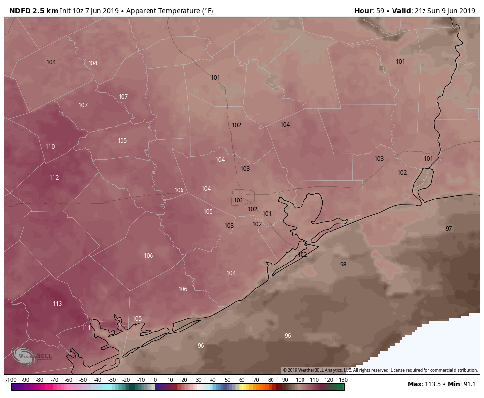
This would be especially true near the bays and coast after the sea breeze moves through, raising humidity levels. Regardless, you’ll want to take it easy this weekend if outdoors. Drink plenty of water, and try to be in air conditioning if possible during the peak heating of the late afternoon and early evening. Our nighttimes will also be warm & muggy, with low temperatures generally in the mid- to upper-70s and around 80° near the coast.

Monday
Right now, Monday looks dreary with a good deal of cloud cover and at least a slight chance of thunderstorms with an approaching cool front. I think the timing and orientation of things is going to change over the weekend, so I don’t want to get too in the weeds here. We will update you on Monday, but suffice to say there’s at least a chance of showers or storms. Expect low- to mid-90s on Monday afternoon.
Legit cold front next week?
Here comes the fun part. Hopefully. A legitimate cold front is going to approach the area Monday night and Tuesday. No, this isn’t a norther or anything; it is June after all. But, this actually is a bonafide cold front. And although it will still be hot behind the front, you will more than likely notice a healthy drop in humidity levels next week for a change.
Showers and storms will likely accompany the front before it presses south toward the Coastal Bend on Tuesday. We should clear out a bit Tuesday night and Wednesday, probably lingering into Thursday. Offshore winds will take over, and that will drop humidity. Weather models have actually been rather aggressive in terms of how far the humidity will drop.
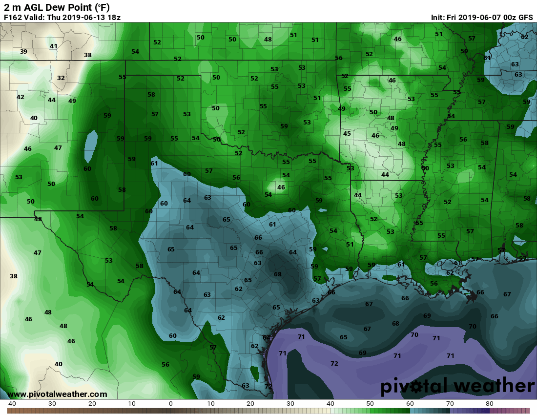
In fact, both the GFS and Euro, if taken literally, suggest that dewpoints will plunge into the 50s (!) behind the front later Tuesday, Wednesday, or Thursday. How unusual are dewpoints in the 50s in June? Between 2010 and 2018, of 6,480 June hours, only 55 of them (or 0.8%) saw dewpoints in the 50s. Since 2014, only 5 hours have been that comfortable.This has the potential to be about as comfortable as it can get for June if the current modeling holds, so let’s hope it does! In addition to this, the drier air would probably allow nighttime lows to drop into the 60s away from the coast. Daytime highs would still be in the upper-80s to low-90s, but again, it will feel a bit less unpleasant than normal. We will update you Monday.
Was really weird driving around town just before 8 PM – Tops of big trees sunlit, everything below dark.
Same here. I had the headlights on and needed sun glasses as I went in and out of the clouds blocking the sun.
While we wait for the cool front, I am seeing that the Houston Chronicle includes a Comfort Index with their weather page. The Index goes from 10 (very comfortable) to 0 (very uncomfortable). Yesterday’s rating was 0, while today is 1. Dang…
Ughust should be about MINUS 3.
Yesterday wasn’t so bad. I’d give it a 4.
Everyone Root for the Cool Front!
Thanks for an awesome review of what we might expect. It’s the weather…ugh…it can change:)