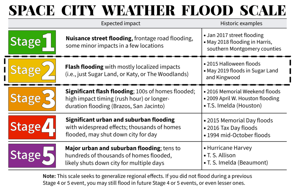
To set expectations for next week’s heavy rains, we plan on implementing a Stage 2 flood alert on our flood scale, and anticipate this warning will be in effect from Sunday evening through Wednesday. This is what we mean by Stage 2 on our five-point flood scale:
Events falling into this category may cause significant, widespread street flooding across large swaths of the area, flooding numerous cars. Other examples of what we would consider stage 2 events are ones that flood dozens of homes in small, targeted areas or specific neighborhoods. These events are either moderate impact over a large area or high impact over a relatively small area.
A couple of notes on this before we jump into the forecast. First of all, it is quite early to be calling for this, as heavy rain is unlikely to arrive before Sunday night at the earliest. However, since most people probably will check out over the weekend—much of which will be sunny and pleasant—we wanted to give our readers a heads up now. Second, since we are issuing this flood alert early, it is very much subject to change. And finally, the area of greatest risk lies south and east of Houston, so that’s where we think Stage-2 like effects are most likely.

As to the overall forecast, not a whole lot has changed. There remain a number of meteorological variables that we can’t yet predict with great precision, and so the forecast models are struggling with rainfall totals. For example, a model might forecast 15 inches of rain for a location in one run, and drop to 5 inches the next run.
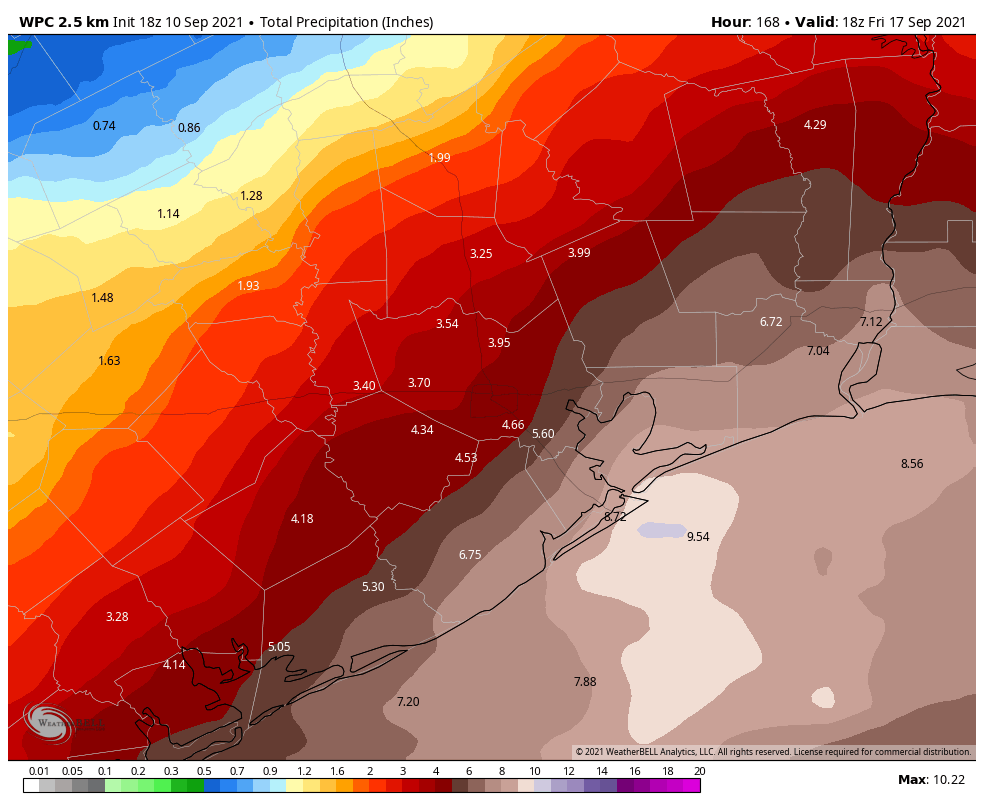
There is fairly good consistency, however, on the overall setup favoring heavy rainfall somewhere in Texas or Louisiana. (Or both!) So if you live within 50 miles of the coast, between Corpus Christi and Lake Charles, you’re potentially under the gun. In terms of accumulations, we anticipate 2 to 6 inches for most locations, but what we’re concerned about is potential bullseyes of 10+ inches. It looks like the most likely period for heavy rainfall will run from Monday through Wednesday.

The bottom line is this: Enjoy your weekend, but also be prepared for the possibility of heavy and potentially disruptive rainfall early next week.
We’ll update on Saturday and Sunday with the latest.
I guess if you live in an area with heavy concrete, then you can have flooding, but those who live in areas with a lot of ground unimpeded by concrete, and because the ground is so dry, I really think that it will be soaked up. Of course, it also depends upon how fast and furious it comes down. Not sure how many inches an hour it would have to come down to cause flash flooding on green space, but I feel safe from any flooding on Sunday and possibly Monday.
That sounds great, but I have personally had my house flooded in a green area under the same conditions. Lots of rain in a short period can cause flooding despite.
Generally, it is true that large green spaces help soak up the water, but there is so much more to consider than this alone for considering how far the water will cover or how deep it will get. Many properly-designed neighborhoods are build such that the streets and parks flood and help to both transport and hold the water, while the houses hopefully stay higher and dryer. Not great for transport and on-street parking, but the best solution we have currently.
My main concern is street flooding. I’m in Dickinson, and while I’m sure my house will be fine, I’m less sure about being able to get to work Monday and Tuesday if some of these models are correct.
Hey guys sorry to ask but can you give me some sort of Idea was Katy will see in the 99 & 529 area please?
Joey, It is best to ask neighbors what affects from 4 inches rain in a 48 hour period will be. As of this post, it is too early whether a tropical wave, a tropical depression or a tropical storm will form. From the map, it appears that less than 4 inches of rain will fall in the next 6 days. There still could be a downpour bullseye in the area in the first part of the workweek. I have lived in Houston nearly 65 years and have never heard of any flooding event in Katy. However, I could be wrong. Good luck in the next week.
I agree it is best to ask neighbors to get an idea of your specific area. I will say though, that I don’t know how one has not heard of any flooding events in Katy as we have seen several rounds of flooding in the last few years. The areas along Mayde Creek have been flooded several times and north and northwest Harris county has taken hits several times as well. With the exception of Harvey, most of the times it has been severe street flooding which has kept people from being able to leave or get to their homes. Main thing to remember is DO NOT DRIVE INTO FLOODED STREET AREAS! It may look OK but you have no idea how deep it actually is or if you will stall out.
Joey, It is best to ask neighbors what affects from 4 inches rain in a 48 hour period will be. As of this post, it is too early TO PREDICT whether a tropical wave, a tropical depression or a tropical storm will form. From the map, it appears that less than 4 inches of rain will fall in the next 6 days IN THE AREA.There still could be a downpour bullseye in the area in the first part of the workweek. I have lived in Houston nearly 65 years and have never heard of any flooding event in Katy. However, I could be wrong. Good luck in the next week.
Any impact likely around the Texans game on Sunday afternoon?
I believe Texans will be washed out… : )
It’s their only hope, honestly.
Up here in The Woodlands, I am looking forward to the rain!! Its been really dry here in the last week so the rain will be beneficial. Being inland, I don’t think The Woodlands will get all that much. 3 inches from Mon-Wed would be nice.
My flood insurance kicks in just in time on Sep 12. I doubt i will need it for this event but it’s still good timing just in case this storm goes all out.
Dewpoints are super low today for Houston standards (mid 50s). Doesn’t feel like there is a lick of humidity. A dry heat in Houston is nice every now and then!!
We are also in The Woodlands hoping for rain even though our yard can take the dry times since we do not have a grass lawn and most of the plants we have put in the ground over the 15 years we have been living here were chosen for hardiness to any weather. We decided too retire here because we like trees and research has shown that living in a “green” environment is conducive to better health, both mental and physical, and being “very” senior we need all the help we can get.
We have many new people in our street. We watch the parade of young adults walking past our house with their little children and dogs every day (we have mostly only local traffic and is a safe street ), and we wonder whether they have any idea of what to do in the event of a hurricane heading in this direction after hitting the coast. It has happen before . We did not flood but a tree fell on our garage and driveway. It damaged our car and our driveway looked like a lumber yard, a big mess, but we and our dog spent the night in the closet under the stairs and we were fine. Keep well everyone.
Is Alvin or Pearland likely to flood?
Alvin and Pearland are south of Houston so they are at a greater risk of flooding than areas that are further inland for this event.
Dang, fingers crossed that the wind shear takes care of it rather than IT taking out my future house.
Don’t want it taking out anybody else’s house or property or lives either in TX, and it needs to leave Louisiana alone too.
This has to be the first time I’ve disagreed with a Space City Weather post. The GFS, CMC, and even the Euro now have the majority of the heavy rain focused on Louisiana. The latest run of the GFS shows nothing but light rain for Houston. The latest WPC rainfall prediction now shows only 2-4 inches for the majority of the Houston area; in seven days that is really nothing at all. I witnessed more ambitious rainfall predictions from that low pressure system in early July that we were dealing with than what I’ve observed in the past 24 hours. Now, as a Houston resident myself, I understand that these models should be taken with a grain of salt. However, I do not think it is a good idea to be bringing out the flood scale just yet, especially since there is a fair possibility that this system may actually end up to bring scattered showers and nothing more to the Houston area.
What is the forecast for the lower Rio Grande Valley?
Guys thank you for everything you do. Wife and I have an international flight Thursday afternoon out of Bush. Any idea if this is going to affect things? I need this trip.
You serious? That is like saying “I have to pass the intersection of Y and Z street next Sunday, do you think it will be passable”.
Jeez…
We’ve lived in our home for 40 years. We were always concerned with rain events such as in this forecast. We did flood slightly about eight years ago. We since paid a small fortune to have our home raised two feet which puts us well out of the danger zone. I feel like I will live longer now without the stress of flood worries. I really feel bad for people whose homes flood. I wish everybody the best during this upcoming rain event.
Thanks for the weekend update! Appreciate all you do.
Track out of BOC looks like Harvey’s path. Depression to explosive hurricane in no time flat. With the hp up north and not much real estate, it’s looking more and more like allison and harvey are having a baby named nick. Sigh.
This sort of thing happens often in September, where heavy rain stalls along the shore and offshore, due to the warm water and the land beginning to cool. I’ll bet anywhere farther away from the coast than downtown won’t have any significant flooding problems.
Unless the tropical storm strengthens significantly, or moves more northerly (rather than northeasterly) and moves through Houston and not offshore, which the high mentioned above may prevent, the flooding problems will probably be by Galveston.
“You don’t need a weatherman to know which way the wind blows.” –Bob Dylan
Thank you for the info. You are the first weather service that has reported this.
How can I subscribe to your service?