Good morning. It’s going to be a beautiful Saturday in Houston, in early September. We totally understand that people are focused on 9/11 remembrances, family gatherings, or other activities today. But there is a potentially serious weather situation developing in the Gulf of Mexico that you need to keep one eye on this weekend. I say potentially because there are some scenarios in which Houston sees only moderate rainfall, and there are others in which we get drenched.
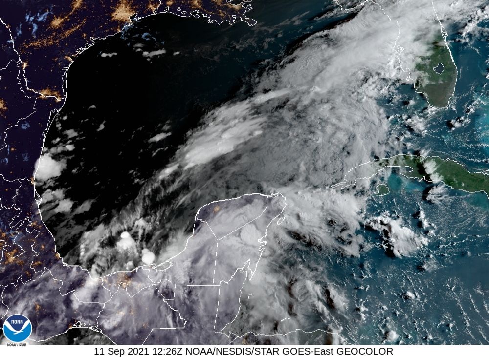
Here’s what we know for sure: It is highly likely that a tropical depression or storm will form over the southwestern Gulf of Mexico within a day or two. This extremely moist system will bring heavy rains, winds, and high seas to the Texas coast beginning late on Sunday. But it’s the details that matter, and we can’t pin those down yet. Based upon the latest modeling and the atmospheric setup, I want to present three plausible scenarios for the next week. As we will discuss, the effects range from mild to extreme, and that’s one reason why it is so difficult to provide an accurate forecast at this time.
Three scenarios
The map below shows the European model’s ensemble forecast for the evolution of the tropical system, which has been designated Invest 94L. It shows tracks from Friday night through Tuesday evening, and I’ve boxed what I consider three of the most likely possibilities. Let’s discuss each of them.
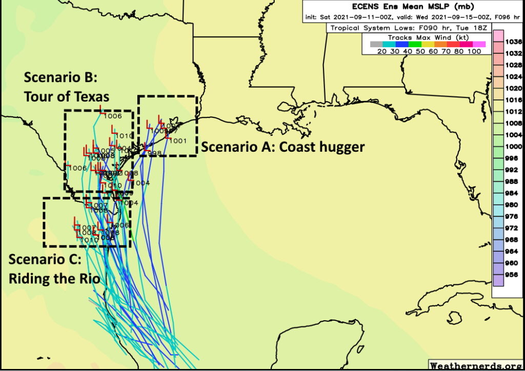
Scenario A: Coast hugger
In this case the storm moves close to the Texas coast on Monday, but perhaps doesn’t come fully ashore. It then moves fairly rapidly to the north and then northeast, bringing its center close to the Houston metro area on Tuesday or Wednesday. In this case we would see higher tides—although probably not too great of a storm surge—and wind gusts of tropical storm force in the metro area. However, the heaviest rainfall would likely fall off the Texas coast and potentially in southwestern Louisiana. In this scenario Houston might see 2 to 4 inches of rainfall, with the 20-inch bullseye remaining offshore.
Scenario B: Tour of Texas
In terms of rainfall, this scenario is more ominous. A likely weak tropical storm would move into South Texas on Monday or so, and slow down for a couple of days. The center would remain close enough to the coast that the storm would be able to tap into Gulf of Mexico moisture. In this case, Houston might expect 5 to 15 inches of rain, with a 20-inch bullseye of rainfall coming somewhere in the area from Corpus Christi to Beaumont. But it’s impossible to say where. The potential for heavy rainfall would linger through Wednesday. Winds and seas would be much less of a factor.
Scenario C: Riding the Rio
It still is possible that the low moves into northern Mexico and basically tracks along the Rio Grande River, dying out after a few days of being inland. In this case the Texas coast would see some moderate rainfall for a few days, but totals for most areas would probably be 2-4 inches, or even less. This scenario seems a little less likely at this time, but it would certainly have the most benign effects for Houston.
Conclusions
So what actually happens? I wish I could tell you. But we’re talking about a tropical wave that has yet to form a semblance of a circulation, so the forecast models are going to struggle with its track. After that, it’s not entirely clear how much the wind shear currently hampering its organization will weaken over the next couple of days as the system moves northwest or north toward Texas. And these are just the beginning of our questions.
The bottom line is that Saturday should see fine weather in Houston. Sunday should start out sunny as well before rain and thunderstorm chances increase during the afternoon and evening hours. After that heavy rainfall is possible through Wednesday, and we just really can’t say how much. But this is a forecast you should be monitoring closely. We’ll have an update later this afternoon or evening.
In Scenario A, did you mean southwestern Louisiana?
probably both.
Thank you guys, as always. The work you guys do and the way you communicate your forecasts is unmatched, and all of us in the Houston Area are deeply grateful for you! Please enjoy this beautiful Saturday doing things you love with the people you love.
Tour of Texas has some ominous similarities to something else that decided to hang out at the coast for a few days, gaining fuel while it did.
Thank you all for your diligent work. We will prepare accordingly!
I feel like this system could take a lot of folks by surprise. Neighbors had no idea what I was talking about when I brought up the possibility of heavy rain. Doesn’t really help when it’s beautiful outside (for Sept, at least).
Just wondering if there is any possibility this could blow up into a hurricane with surge and many downed trees? Would we know by now if this disturbed weather is going to turn into a situation dangerous enough to evacuate?
Biggest threat will be flooding and that is cause to evacuate. If you flooded in Harvey, you need to have an evacuation plan in place.
Thankfully I didn’t flood during Allison or Harvey..16-20 inches of rain over 3 days has me more than likely hunkering down at home..
Eric, I am wondering that too. If it does scenario A, wouldn’t it stay over the VERY warm (upper 80’s) Gulf of Mexico for long enough to strengthen into a hurricane or something? Or is there another factor that might keep it weak as it nears Texas?
I’m worried /curious about this as well, if there’s still much chance for strengthening. If not, why not? I’m one of the lucky ones not worried about flooding, but I’m so afraid of a tree falling on my house and crushing me that I evacuated for Laura! And I don’t even live in Katy…
Exactly my case..We have two large trees in the back yard close to our house…One could fall over my bedroom, the other could fall over the dining room..We’ve had a rough two years and have not been able to afford having a tree expert come and trim our trees and fix our landscaping..So our go to plan is to evacuate our area if we think the winds will be hurricane force..
I keep thinking about Claudette in 1979. Hugged the coast and dropped 49 inches of rain in 24 hours over Alvin, Texas. Broke all records of rainfall in 24 hours. It may still be the record holder. It definitely flooded the areas surrounding Alvin.
Claudette was 42″ and doesn’t hold the record any longer. Though it may for Texas itself still in a 24 hour period. Harvey by far has the record for most over the duration of the storm.
Looks like the GFS and NAVGEM favor Coast Hugger, and the European favors Tour-of-Texas. CMC has it kinda burning out (Ridin’ the Rio?).
Thank you for the facts! We will plan accordingly.
Katie
Sixty years ago today, Hurricane Carla made landfall and made an impact on my then seven-year-old life. Hard time of year.
If the team at SCW isn’t exactly sure what this storm is going to do, then NO ONE else does either. And, I’m going to guess those in search of “ratings” will be flogging this all day today and tomorrow. Thanks Eric for the “three scenario” description. I’ll tune out the “usual suspects” on Twitter and rely on you and Matt for accurate and timely info.
Apparently there is no definitive steering current for this system and that’s not good.
Thank you for everything you do
Any chance this will do the rapid intensification that ida did? Just trying to gauge how worried I need to be in El Lago, close to both Clear Lake and Taylor Lake? We didn’t flood in Harvey, but houses right down the street did and we were trapped by street flooding.
If there’s any surge along with that amount of rain fall it worries me.
Typo with the title. Or is the storm called system now.
A Tropical Storm is not just a storm in the tropics. A Tropical Storm is defined as an organized system of strong thunderstorms with a defined circulation and maximum sustained winds of 39 – 73 mph (34-63 knots). This thing doesn’t have either defined circulation or sustained winds of 39 mph (plus) yet. So at some point in its existence, it may become a tropical storm, but it isn’t one yet.
Speculations…people stop freaking out! Will it rain? Likely! Will it cause flooding? Likely!
Should you evacuate? Do what you think his best for you, don’t wait for someone else to make that call! If you listen to the main stream media, you’d better run for your life! Sensationalism at its best. Thanks scw for your forecast
I need to plan for our blood supply for next week. Can you tell me when your next update will be? I only believe your reporting.