Summary: Our warm pattern continues, with humid days and sultry nights heading into the weekend. Then, with the approach of a front, we’ll see widespread showers and some thunderstorms. These will likely peak on Saturday night and Sunday morning before drier air starts to move in and we see a couple of cooler nights.
Wednesday
As I write this low temperatures outside are in the mid-70s for much of Houston, with a relative humidity of around 90 percent. That is not quite summer-like sticky, but it is definitely rather warm for April. The record high minimum temperature for today, April 17, is 74 degrees. The city’s official monitoring station briefly hit 74 degrees this morning, so it’s likely we’ll tie the record for warmest low temperature for today.
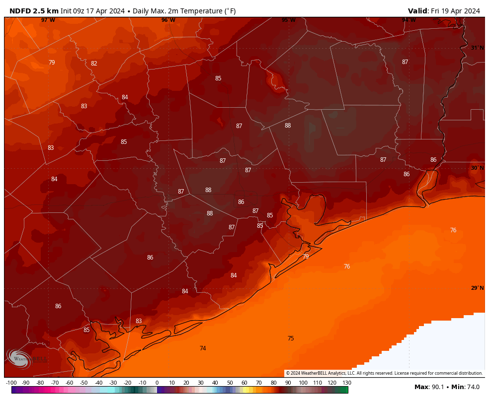
The warm and sticky weather will continue into the weekend. Highs today are likely to top out in the mid-80s, with mostly cloudy skies. Winds will be light, generally from the south at 10 mph or so with higher gusts. It will be another warm evening, but there is enough moisture about to potentially generate some light shower activity later this evening, perhaps after 9 pm, and into the wee hours on Thursday morning. Don’t expect much in the way of accumulations. Any showers are likely to be fairly scattered.
Thursday and Friday
These will be a pair of warm and mostly cloudy days. Expect highs in the mid- to upper-80s with plenty of humidity, and southerly winds at about 10 mph with higher gusts. While there will be plenty of moisture in the atmosphere, a stout capping inversion will be in place that should limit rain chances to 10 or 20 percent each day. Nights remain warm, in the low- to mid-70s.
Saturday and Sunday
A cold front will approach the region this weekend, and eventually move through the area early on Sunday morning. This will determine our weather, and when and where we see rainfall. For now, I expect Saturday to see mostly cloudy skies, highs in the mid 80s, with scattered rain showers. Rain chances will increase on Saturday evening, and through the overnight hours, as the front nears and passes. At this point, rain chances look to be higher, along with a greater potential for heavy rainfall, for locations north of Interstate 10. There is, as yet, no strong signal for severe weather beyond typical thunderstorms.
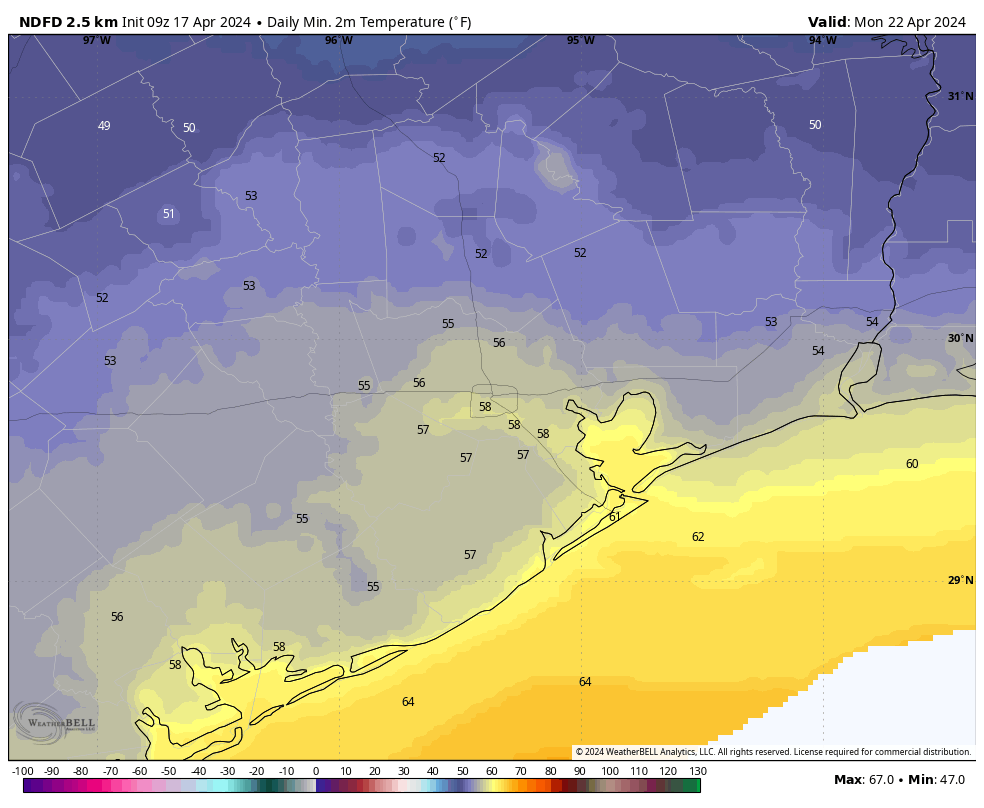
Sunday will be cooler, with highs likely in the low 70s. Although some drier air will be moving in, some showers may linger near the coast in the morning. Skies should start to clear some during the afternoon hours. Lows on Sunday night will drop into the 50s for most of the area. This may be the only night in the 50s with this front, so enjoy the cooler and drier air.
Next week
Monday will be another pleasant spring day with drier air, a fair amount of sunshine, and highs of perhaps 80 degrees. After that we’ll start to warm back up with a fair bit of humidity. Look for highs in the mid- to upper-80s during the second half of next week.
If you’re planning to participate in the Texas Bike MS 150, it’s still too early to have too much confidence in the forecast. There’s no strong indication of rainfall or storms, and the most likely outlook is fairly warm and humid weather. That would tend to imply a nice southerly or southeasterly breeze for the rides to La Grange and College Station, but I would be a fool to try and predict winds this far out.

Could you comment some on the weather in Dubai yesterday (record flooding)? From what I’ve read, all the rain yesterday was produced through cloud seeding (Dubai normally gets little to no rain as it sits at the edge of a vast desert). It seems to be a very interesting development if true.
IMO it is not from cloud seeding. There is a mid-latitude low bringing a cold front now across Pakistan. Yesterday the low was more centered over Iran with a trailing front draped across the UAE, Saudi Arabia, Yemen, and Oman with a lot of Red Sea/Persian Gulf/Arabian Sea moisture wrapped into it. Today it’s producing torrential rain around Pakistan. Dubai is only about 25 deg N, so the same latitude as Miami. There are fronts that go through the Caribbean with rain all the time.
A report on the BBC today confirms the record rain fall was not the result of seeding but a long expected front crossing through the area and on up to Iran, etal.
Matt did a post on this on the Eyewall blog. The tl;dr – The cloud-seeding notion is dubious at best.
https://theeyewall.com/dubious-dubai-flooding-claims-run-rampant-whats-the-reality/
A few days ago, I had to let my AC unit know its break was over and its 7-month work cycle is back. The AC unit was not amused.
Only seven months?
What the hell is with the GFS forecasting 93 on April 26, with upper 80s to low 90s the entirety of next week?
We’re kind of surprised that you think this is odd? Is there a nuance to your point that I am missing…My GFS look showed 88+ that day but if sunny blue it could get 93.
Gee, if this is April, I can’t wait for August.
Why are the models forecasting the storms Saturday night to bring rain to areas west, north, and east of us but skip over the houston area??