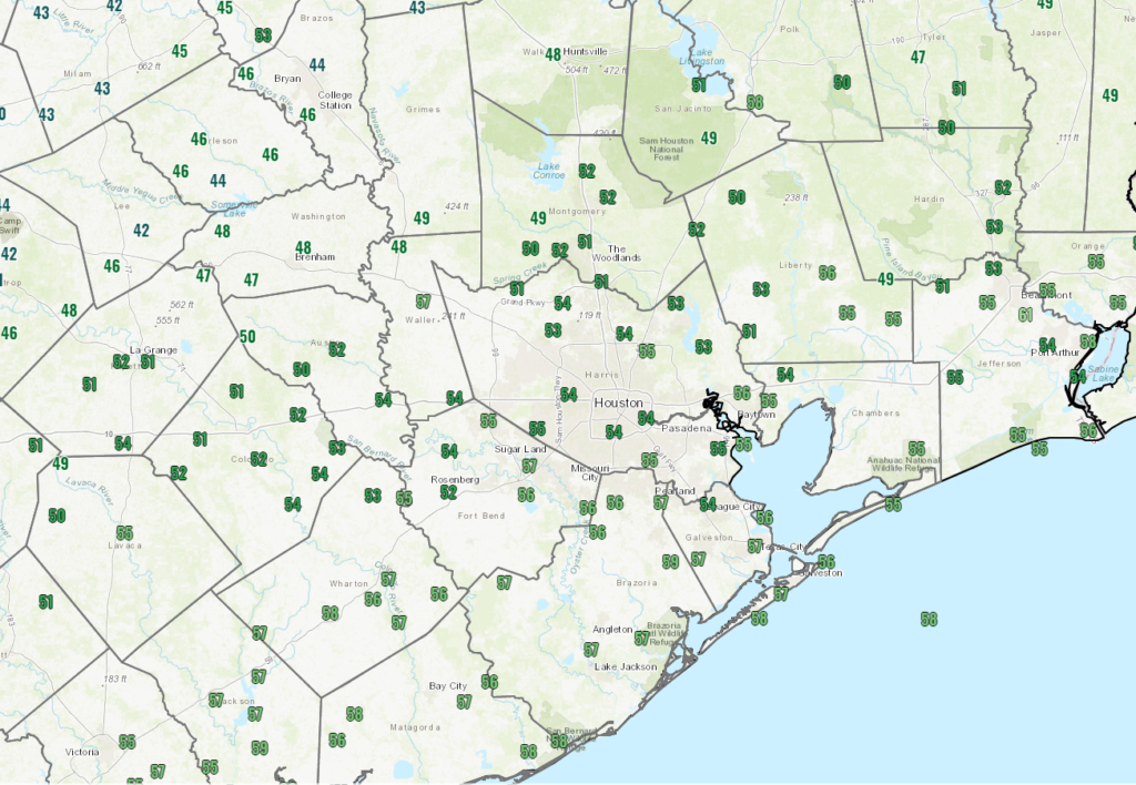
It was officially 80 degrees yesterday in Houston. We fell one degree shy of the record high at both Bush & Hobby on Thursday. Today will not be a repeat of that, not by a longshot.
Today
It’s starting off in the 50s and upper-40s this morning, and honestly, temperatures may not go very far from these values today.

Today is going to be one of those chilly, raw, damp winter days here in Houston with off and on showers or light rain, a lot of clouds, and a bit of a breeze.
We could use a little rain, so hopefully we can snag a couple tenths of an inch here or there through the day. Look for showers to diminish tonight, with partial clearing and lows generally in the 40s, though a few spots up north could drop into the upper-30s.
Weekend
Tomorrow will start similarly kind of gray. We should hopefully see breaks in the clouds during the afternoon. And we’ll see complete clearing once another cold front sweeps in Saturday afternoon or evening. Ahead of that front, look for highs in the 60s tomorrow. A chilly night is on tap for Saturday night with lows dropping into the 30s and 40s. Sunday looks spectacular. Expect a lot of sunshine, high temperatures in the 60s, and light to moderate winds.
Monday through Wednesday
Onshore flow will kick back in late Sunday, so Monday morning will not start off nearly as chilly as Sunday morning. Look for morning temps in the 50s, with a few upper-40s scattered about. Clouds will be with us on Monday as well. Despite the clouds, temperatures will surge to near 70 degrees.
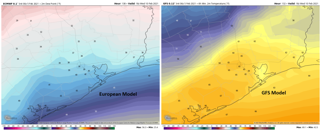
The forecast begins to fall off the rails Tuesday with some changes since yesterday. A cold front is projected to get close to Houston by Tuesday afternoon. Models differ dramatically on the timing and orientation of the front through Wednesday and even Thursday, with the GFS model stalling it in our neighborhood and the European model suggesting it stalls well offshore. A map of forecast dewpoints for Wednesday shows this well.

This obviously has implications on everything from temperatures to cloud cover to fog potential to shower chances for next Tuesday and Wednesday. If the front clears, expect highs in the 60s or 50s Tuesday and Wednesday, with lows in the 40s Wednesday. If the front does not clear, expect highs in the 70s, perhaps well into the 70s and lows in the 60s, along with fog at the coast or even into the city. Normally, I’d say the cooler outcome is probably correct, but the GFS model tends to have a bias where it’s too fast with fronts pushing offshore so seeing it be opposite of that gives me a little pause. At the same time, models tend to struggle with the type of cold air masses we are expecting in our region by midweek next week, bringing them in too slowly. So the forecaster’s conundrum is in place next week, and either outcome seems perfectly reasonable. We’ll have a good bit more clarity on Monday.
Late next week
The forecast really goes off the rails later next week. All we can tell you at this point is to expect unsettled weather and potentially the coldest weather of winter. Models have taken a bit of a dramatic step colder since yesterday for next weekend, with most reliable model guidance indicating a freeze, if not a hard freeze will be possible focused on Saturday or Sunday. Whether or not that actually happens will depend on how the potential for rain or wintry precipitation exactly plays out next Friday and Saturday. I think Eric’s 20 percent call on snow risk is still reasonable, though I think I might unfortunately call it “snow OR ice” right now. I wish we could be less vague, but this period has been in flux for several days. Either way, we believe you will want to continue to monitor the forecast for the end of next week and weekend in the coming days and be ready to implement your cold weather preparations later next week. It’s been a minute since we last saw 20s in Houston in February, last occurring back in 2014. A reminder that, although rare in recent years, it can absolutely still get quite cold this late in our winter. Much more to come on this.

TV weather forecaster next Friday : “Stay home today, it’s going to freeze!”
Us : “We already ARE staying home. Every day.”
A lot of us are still going to work every day. I’d love to work from home in my sweatpants but unfortunately that’s not in the cards.
After 10 months of work from home, and being in the office maybe 2-4 hours a month for safety training, etc., I’m sick of it. I miss my coworkers and this house feels like it has become a prison.
Sweatpants under the suit. No one will know…
I love cold weather! Thanks for the no-hype, yet exciting forecast. I’ll be watching this page for regular updates. Based on what I’ve seen, it looks like the snow will come in Friday AM with a line running W-E from Cypress to Dayton, with more snow to the east than west. This is based on looking at all the cities where snow is currently predicted and the chance of snow. Any further north, and it looks like you get behind the precipitation, further south and it’s not quite cold enough.
Thanks Matt!
any rain with the front on Saturday? we are planning to grill outside for dinner.
It got down to 19 degrees I believe in 2017. So we’ve been really cold after 2014. Just sayin.
I thought so too because we had a busted pipe in the attic with that freeze but apparently that was in January of 2017.
https://www.timeanddate.com/weather/usa/houston/historic?month=2&year=2017
https://www.timeanddate.com/weather/usa/houston/historic?month=1&year=2017
I don’t believe that was in February.
It hit 21 in January 2017 and 19 in January 2018. Yes, it has been colder. It has not been colder in February, however, since 2014, which was what I was saying.
I’m sure the snow line will stop right at the Houston city limits like always with plenty of winter weather occurring north to the nth degree. You’ll see live news coverage in places like Conroe, woodlands, and spring which could see a foot of snow… but not kingwood because they were annexed by Houston, which might see a few ice droplets if you look at it from the right angle.
The radar will show Cypress getting a ton of snow while residents of Cypress excitedly look out of their doors only to see rain with a few icy pellets.
I like our Houston “winter” since it means a break for the A/C and the ability to walk around outside more comfortably. But, let’s get carried away with it next week.
Can we transfer some of this (say 10 degrees of coolness) to April or May? I’m not picky – you can choose any day in those months.
May, put it in May!
Thank you Eric and Matt for all you do. You mentioned snow…should I put snow chains on the tires?
Only in Katy.