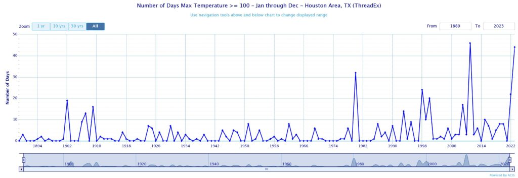
Good morning. Today is likely to be the final, exceptionally hot day of 2023. I expect temperatures to reach 100 to 107 degrees across the metro area today underneath sunny skies. We also have a pretty good chance of peaking at 100 degrees on Saturday before temperatures dip just a bit by Sunday. That’s interesting from a historical perspective in terms of 100-degree days. To date, we have recorded 44 such days this calendar year.

Back in 2011, which anyone who lived here probably hasn’t forgotten, the city recorded 46 days with highs of at least 100 degrees. That broke a record previously set during 1980, 32 days. So with today a certainty to hit 100, and Saturday quite possibly, that would allow us to tie the record set in 2011. Will we break it? Certainly we will have some days in the mid- to upper 90s in the week ahead. But I’m not sure we get another 100-degree day. And to be honest, I’m OK with not breaking the record. Aren’t you?
Friday
Today is going to be excessively hot, no way to get around that. We’re going to see much of the area push into the 105-degree range and it’s going to be miserable. The only good thing I can tell you is that this really is our last fling with ridiculously hot weather in 2023. We really are going to see a pattern change to cool things off (a bit) next week, and then we’re into late September and this madness will be over. But no getting around that today is going to be brutally hot and you definitely need to take heat precautions.
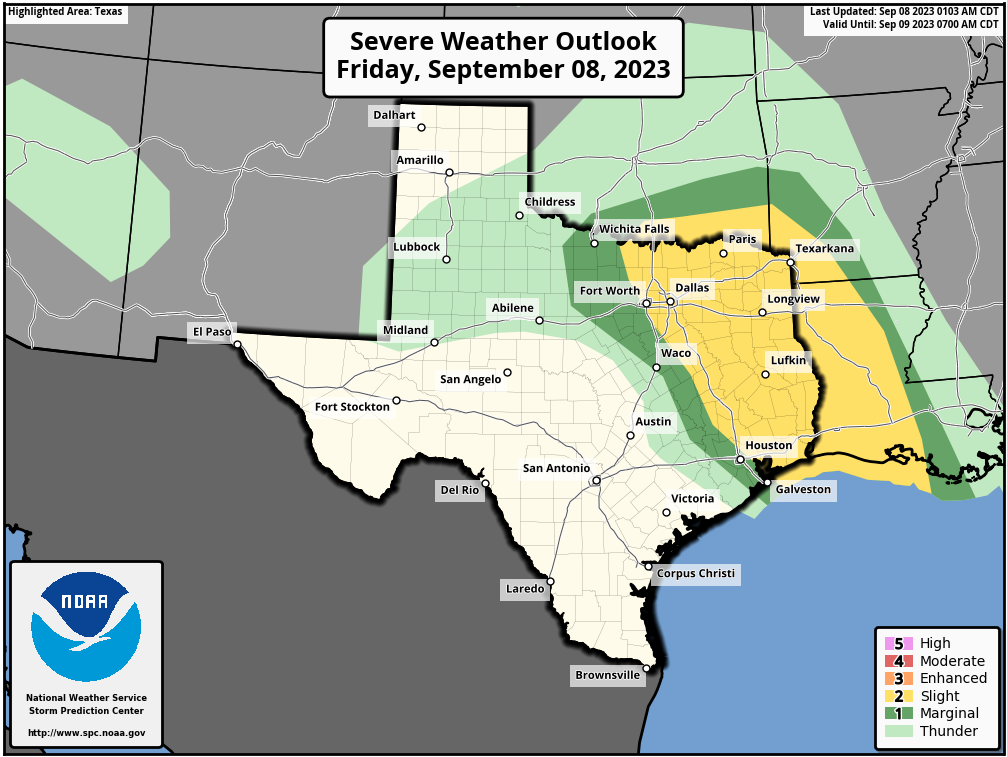
One thing we’re watching for is the possibility of late-afternoon and evening storms dropping down into the Houston region from the northeast today. It’s possible as the capping inversion probably will be weak later today. In runs produced last night, some of the high-resolution models got really aggressive in developing these storms, but they have since backed off. NOAA’s Storm Prediction Center has the northeastern part of the metro area under a “slight” chance for seeing severe weather, likely in the form of thunderstorms and damaging winds, later today. My sense is that any strong storms fizzle before reaching Houston, but there is a chance.

Saturday
Highs on Saturday will range from the upper 90s to 100 degrees, with perhaps a 40 to 50 percent chance of rain. Temperatures will depend on rainfall amounts and timing. For the most part these showers will bring only light accumulations of rain, but a few areas may get higher totals under stronger storms. For the most part, when it’s not raining, skies will be mostly sunny.
Sunday
Look for mostly sunny skies with highs in the mid-90s as the high pressure ridge recedes westward. Rain chances will be on the order of 30 percent, with mostly sunny skies.
Next week
Temperatures will continue to trend downward next week, as a weak front drifts into the region and slightly lowers our humidity levels. Basically, we’ll probably see highs in the low- to mid-90s for much of the week, with perhaps a 30 percent chance of rain each day. Who knows, a few areas may even see a high in the upper 80s on a day or two. Nighttime temperatures will drop into the 70s. It’s not going to feel fall-like like, but it certainly will feel a lot more like late summer, which is how it is supposed to feel in mid-September.

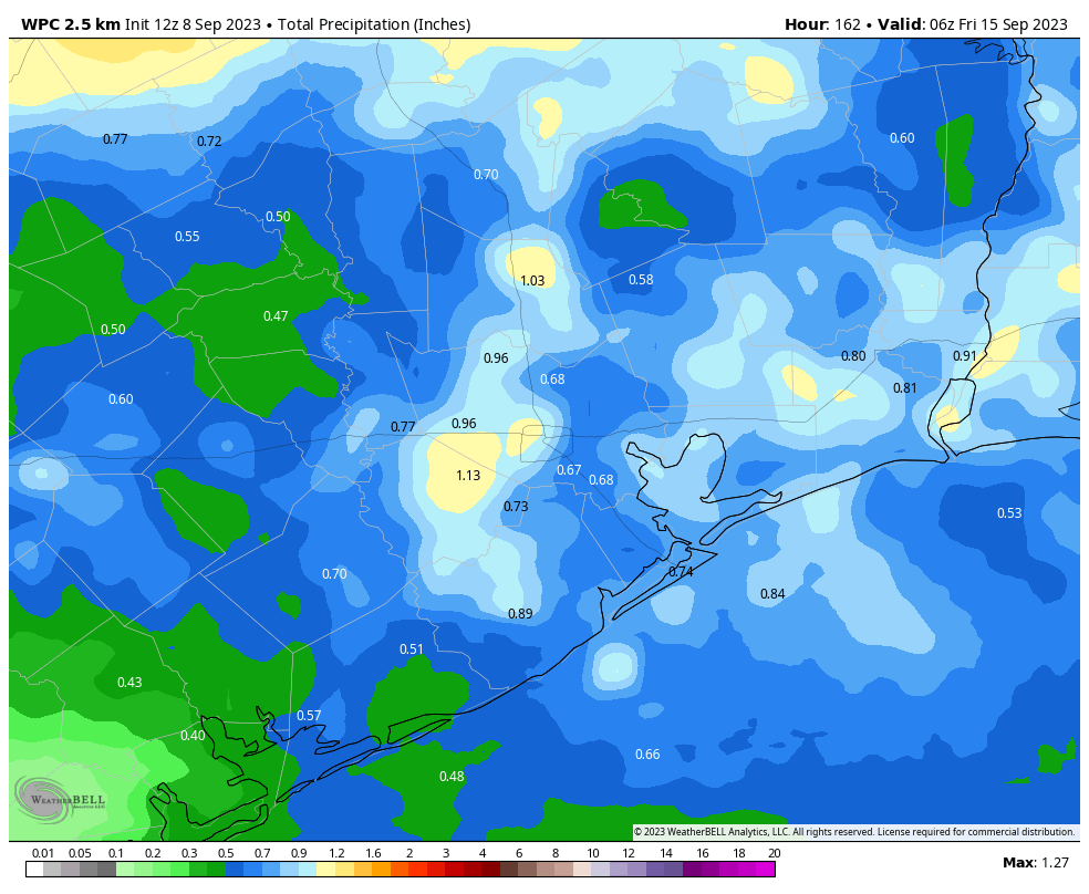
Unfortunately, while most of us will see rainfall, I don’t see the kind of drenching rains we need to break the region’s worsening drought. Still, 0.5 to 1 inch over the next week is much better than nothing, and far more than many of us received in July and August.


To the contrary. If we have to get to 109 multiple times and tie the record, let’s just get to 110 and set the record. Same for number of 100+ days. Don’t tie it, break it. The pain is the same.
No, the pain is not the same. There is physical pain and mental pain involved with breaking heat records. Not to mention the stress on physical infrastructure (e.g. water mains, foundations, A/C units).
“A change in the weather is sufficient to recreate the world and ourselves.” ― Marcel Proust
I saw a post on Youtube how the exhaust from hurricane Jova in the Eastern Pacific may kickstart the subtropical jet which would likely initiate a change from the cycle of death we have been into a cooler and wetter pattern more typical of an El Niño year.
On a positive note while it does not “feel” like fall around here my yard looks like the opening scene from “It’s The Great Pumpkin Charlie Brown” with all the leaves that have fallen from drought and heat stressed trees.
Dude, knock it off. I just spat my orange juice all over my keyboard. You happy now? Charlie Brown, Bruh. 😂
The Jova scenario is an intriguing one, lets see if that plays out and deliver us from the hard time in the summer clink we are in.
Wow, give me 1910-1980 Houston weather, please!
Give me 1910-1980 atmospheric CO2 concentrations, please.
Ha…agreed. Didn’t want to get everyone riled up so early in the morning…
No problem. Go back to a 1910-1980 standard of living.
So, ERCOT will be asking us to conserve energy this evening to avoid rolling blackouts, the DOE has declared an energy emergency in the state, yet we are playing high school football tonight – – under the lights? Can’t they push the games bac a day or two?
Nope. Can’t play on Sundays. Also, there aren’t enough officials/locations for teams to play just on Saturday. Trust me, it’s has already been bad enough out there practicing in this stuff. I’m ready to have a full practice without having to stop every 15 minutes for the 5 minute water and rest period.
Playing High school football in these conditions is absurd, and I suspect only done to satisfy the coaches.
It’s no easier on the guys doing maintenance in our plant. Some of it can’t be done safely under lights.
Those lights downtown should be turned off first for unused offices! 🙄
With the air traffic into Hobby, some of the lights need to stay on.
Many stadium lights are LED’s now.
I’m amazed that you manage to find a way to complain in these comments every single GD day.
With regards to the Record of 100-degree days, by year, graph, does NOAA have a similar trend for below 40° or 32°F?
The nearby Lake Charles NWS office believes that the HRRR (the only CAM that backed off, others still show development through the area) is not handling the storm development well.
Meanwhile, the ARW is very early (1-2PM) while the other models (including globals) all aim for 3-4PMish. (As of time written).
Fingers crossed for the best (rainiest) outcomes both today and through the rest of the month.
The Lake Charles forecast offices believes that the HRRR (the CAM that backed off the most) is not handling development well. On the other hand, that WRF is very early (1-2PM), while the rest of the models +globals show more 3-4PM (hence highest confidence).
Hoping for the best (rainiest) outcomes.
I have been in autumn for about three weeks now. This weekend is the start of the Christmas season.
I was in NH last weekend. 68F. It was awesome.
Quick edit (I think and hope). Your Severe Weather Outlook map is captioned “NOAA storm outlook for Wednesday and Wednesday night. (NOAA).” The inset title states that it is for Friday.
Question, What’s the rainfall comparison at Hobby and Bush airports during the 2011 drought and 2023
June-mid September? We’ve mostly heard numbers on temperatures
Looking back at 2011 vs 2023 for Bush, we’ve had about 5 inches more rain to date for 2023 than for all of 2011. We should end the year significantly higher.
Thanks for calm and rationale details here. At the same time as I receive SEVERE STORM THREAT! alerts from the usual sources
Completely subjective, but 2023 has been much harder for my mental health than 2011. In 2011 I was still in my 20s and had only been in Texas for four years. It was bad but, for whatever reason, did not depress the hell out of me like this summer did.
Not sure why the difference. Only thing I can think of is all of the Texas summers in between and the pit in my stomach or knowing I likely have at least 15 more of these summers being locked inside for 3-4 months before I can retire. A lot of it is likely due to being older and grumpier.
For those of you who also get summer SAD, there was a NYT article a month or so ago about how summer SAD is real. The heat messes with brains fairly significantly.
I think the issue for many is that this summer could be an indication of what might be coming. If one had to imagine every summer from now on being like this one, I wonder how many might not be able to face it and just want to give up?
This. What is the read from the gallery? Merely ENSO shifts or some new disequilibrium with rapid climate warming. If it’s the latter why does that produce just semi-arid heat – with blasts of <15 cold – as opposed to humid tropical with some precipitation. For me the heat is fine. I just can’t stand 64 days and counting of straight sunny sky. We’ll have to see if there’s a 3peat in 2024.
There is definitely a lot of that. Regardless of cause (which I personally think humans contribute to but is almost certainly more nuanced in terms of natural factors playing a part as well), these types of summers will only become more common, if not the norm, based on temperature data.
I wasn’t here in 2011, but I must agree – this summer has been a nightmare. I think a large part of my suffering comes from the fact that at work we have no shade in our lot, and getting into the car at the end of the workday has been utter misery. And then, as DJ said, there is something maddening about days upon days of blazing sun. Now I know: I couldn’t live in the desert, even with the so called “dry heat”. I also feel like this summer is tipping me towards possibly leaving Houston in the long run… not that we can actually escape extreme weather anywhere, but as an east coaster, I’ll take months of cold over months of heat any day.
M, you nailed the right phrase …”maddening days of blazing Sun”. It was actually pleasant this morning; nice breeze, a few clouds, but by 0900 nothing but blue sky – maddening! – I’m now well familiar with 500 mb features.
EC has its merits but I could not stand the I-95 corridor.
I have a covered lot and it is still almost uniformly 96 degrees when I get in my car after work. Sad. I Finally found my dream job but I don’t think I can do this type of summer if it persists for the next year or two.
I think it’s the overnight lows Jeff. In August 2011 there were many days with lows in the 70s. Now, it simply does not cool off at night anymore. Heck, last night, September 7, it was 98 degrees at 7:30PM at my house. It’s absurd. When it doesn’t cool off at night, I am always in a bad mood, and also worried about my AC system which drones on and on and on into the darkness.
Fantastic point. That probably is the worst part of the summers here. Instead of cooling off, it’s like a hot wet blanket gets thrown on everything at night. I doubt people realize how big a deal it is for it not to cool off at night until they experience it.
What do you guys think about Hurricane Lee?
I think it’s behaving nicely by trying to be a fish storm
We’ve got full daily coverage of Lee on The Eyewall. Certainly something for the Northeast to watch carefully.
https://theeyewall.com/
Watching a really impressive line of thunderstorms spanning the entire state of Louisiana and trying to build its way westward across East Texas as well. Sure hope these rains will hold together and slide into the Houston area with some regional impact. Glad that we are marginal for the severity side of the coin. Rain yes, wind damage, no. Fingers crossed.
I sure picked a great year to move to Houston 😀 Can’t wait to not pay >$100 a month on my A/C!
I’ve been wondering what the recent transplants from places with pleasant summers have thought of their recent move LOL.
There are two seasons in Texas: Gold Bond season and non-Gold Bond season. Winter is usually scheduled for 3-5 days in January so just be prepared for that 😉
Probably time to do away with the comments section, huh?
Why something wrong today Scott?
Will never complain about a high of 93 ever again. On the plus side.
I think the depression with this summer is mostly because this past July and August was actually worse than the July and August of 2011 heat wise. And so far this September is worse than the 2011 September. The only difference this year vs 2011 was June 2011 was significantlly hotter than this past June. The only reason we didn’t obliterate the record summer of 2011 is because nearly the first half of June 2023 was cooler than normal.
Not to mention, the drought was much worse in 2011, as things were already severe even in spring, before (nearly) the entire state went exceptional by summer’s end. Similar to the last summer, where the problems were front-loaded with a bad May, June, July, only for August 2022 to deliver more relief.
That high ridge or high dome is one powerful system of High pressure. It has blocked everything the last 2 months and it continues to impressively do so. I may not like it, but I do marvel at how it has total control of us. Remarkable
I completely agree. That is one of the things that sparked my interest in weather. I have always admired the power that weather\nature has over us.
Meh. I only agree in-so-far that the science is interesting to learn: including the dynamics/mechanism behind its formation, where/why it tends to be located, etc.
Otherwise, given the compromise it causes to agriculture, biodiversity, cultivation, ecology, etc of the area, I don’t care for that form of “nature’s power” anymore than I care for cancers, infectious diseases, predation, etc. If it means having to use full-scale human intervention to get rid of that thing (cloud-seeding, terraforming, etc), then so be it.
Meh.
It is so excited to see rain in the broadcast but unfortunate over 50.days my area has not had any drop of rain so I am not excited of your prediction about the rain . I hope I can have more precise information about my area weather broadcast thank you 1960 and 290 area .
Big storms developed just north of Sweeny here in Western Brazoria County. All I got were a few sprinkles in my yard. It truly has gotten laughable at this point.
Can you explain why the storm that was barreling down from the north east to southwest at about 5:30pm on Friday went from super cell to no rain at all in 25 minutes.
When you live here awhile you learn that precipitation is really a magical thing. One thing you got to have is ability for clouds to grow upward. That doesn’t happen here in Houston.
Most likely because the rain cooled air collapsed under the storm which cut off the hot humid rising air. The heat of the sun and the warm humid rising air is basically the fuel for these types of storms. Once the rain cooled downdraft falls to the ground there is no more warm humid air to feed into the storm so the storm pretty much rains itself out soon after.
At about 5.30pm Fri, heard thunder, then 15 minutes later, the rain started. I was very shocked that it lasted about an hour. Been our experience, it’ll rain all around us, but never on us, so yea, very surprised and glad for the downpour.
We are just shy of Pinehurst (and Stagecoach), which is between Tomball and Magnolia.
Amazing. A giant thunderstorm line came out of seemingly nowhere! And apparently it’s going to last till 9 AM.