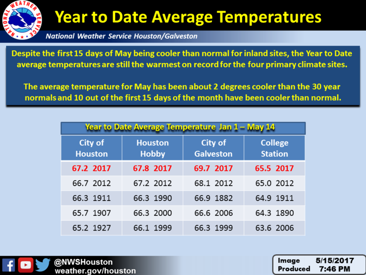
The National Weather posted a pretty astounding graphic this morning. Although temperatures this May have been cooler than normal for most of Houston—except for areas immediately along the coast—the region is still off to a sizzling start for temperatures this year because of warmth during the prior four months. For every major weather location in the area, the average temperature this year is above normal. Galveston remains nearly 2 degrees above normal.
Today
After a warm-ish morning, temperatures will reach the mid- to upper-80s today under partly to mostly sunny skies. The most notable feature will be onshore winds returning with feeling, perhaps gusting to 20 mph or above. This moisture will likely set the stage for rain showers later this week.
(Space City Weather is sponsored this month by Jetco Delivery)
Wednesday through Friday
As moisture levels rise, some rain chances will return to the area both of these days, likely during the afternoon hours. Because there’s no great mechanism for storms to form, I’m expecting scattered showers, with fairly low accumulations. Most areas won’t see rain, and with otherwise partly cloudy skies look for highs in the mid- to upper-80s and warm nights.
Saturday and Sunday
Hard to say. A slow moving cold front (it’s May, so don’t expect much cooling) will be moving across the state, and push into the Houston region likely sometime on Sunday. This will create the chance of rain, but won’t necessarily bring rain for everyone. I’d anticipate some scattered to widespread showers on Saturday (with accumulations of less than one-half inch where rain falls), and perhaps a little bit more than that on Sunday. Forecast models have backed off their predictions for heavy rain, so while that remains a possibility, I’m going to discount it for now. Highs will be in the mid-80s, with lows around 70.
Early next week
This pattern looks more or less to repeat itself as yet another late-season front slogs through the area and brings a healthy chance of rain to the region, with the best chances occurring later on Tuesday or Wednesday. No promises in terms of late-season cooling, but this one has a chance to bring overnight lows down into the low 60s for at least one night later next week.
All in all, the forecast looks to turn wet over the next week, but it’s not clear how wet—two tenths of an inch of rain, or two inches or more?—we’re actually going to get.
Posted at 6:40am CT on Tuesday
More rain please!