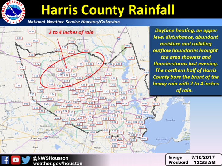
The absence of high pressure, summer-like moisture levels, and some atmospheric instability due to an upper-atmosphere disturbance led to some impressive thunderstorms on Sunday evening—what a lightning show—with the northern half of the Houston area generally receiving 1 to 4 inches of rainfall. I don’t think accumulations will be quite so high today, but we’re going to remain in this wetter-than-normal pattern into the middle of this week.
Today
The atmosphere remains moist, and we’re already seeing some showers and thunderstorms develop over Montgomery County. Based upon these trends, rain is likely north of Interstate 10 this morning, and showers should move closer to the coast this afternoon. For the most part we’re looking at a few tenths of an inch of rainfall, but as these storms are slow-moving, some areas could pick up 1 to 2 inches over time. Highs should remain around 90 degrees. As was the case on Sunday evening, storms may well continue late into the evening.
Tuesday and Wednesday
There will likely be less impetus for organized storms by Tuesday, but with the absence of stifling high pressure we’re going to see some decent rain chances, especially during the afternoon hours as temperatures rise into the low 90s. Showers should be scattered, for the most part.
Thursday and Friday
Pressure levels should rise toward the end of the work week, which will help to limit rain showers—but I don’t think they’re going to go away entirely. Look for high temperatures in the low- to mid-90s.
Saturday and Sunday
I’d expect the first half of the weekend to be a lot like Thursday and Friday, with only a relatively modest chance of showers and fairly warm temperatures. However by Sunday it looks like we could see some healthy rain chances (nothing too extreme) as high pressure again recedes.
Tropics
We’re coming up on the middle of July, a time when we should start to see some tropical waves rolling off of Africa and potentially moving toward the United States. The GFS model is notorious for developing these waves into big, powerful tropical systems, and often when you look at long-range runs (i.e. 7 to 15 days out) there will be something ominous. See, for example, this tweet from Sunday:
*Potential* development by late next week. Nothing imminent ATT. It’s just a model. NOT to be trusted at this range. pic.twitter.com/XlBoLT2SJA
— KHOU Weather (@KHOUweather) July 10, 2017
At present there is the potential for a wave to develop by this weekend, and move toward the Caribbean Sea. But we’re a long, long way from having to worry about that, and any eventualy movement into the Gulf of Mexico. Rest assured, if there is something real to worry about in the tropics, we’ll let you know.
Posted at 7:30am CT on Monday by Eric

Good Morning! OK, so, since you moved to the new server, Feedly isn’t displaying your entire post, which means clicking over to your website – which isn’t the end of the world except my iPad is old and crappy and doesn’t do the whole “website via Feedly or Twitter” thing very well. I recognize this is not your problem, but if there is any chance it’s a simple “Oh, we forgot to click the ‘download the post to Feedly’ button,” and easily remedied, that would be great. I’ll keep reading either way, though! No worries there!
Thanks Trish. And yes, we’re still working out some kinks. Hope to fix that in a day or two.
Hi Eric, I haven’t received an email from you guys since Monday ((7/10). Just checking to see if you haven’t sent any since then or if I just stopped receiving them for some reason? (Can’t do without my daily forecasts from you.)
Hi Wes, We’re still migrating a few things over with the server changes. It’s not you! We’ll let you know if you need to resubscribe for some reason. Keep checking the site or our Facebook/Twitter for the latest on that.