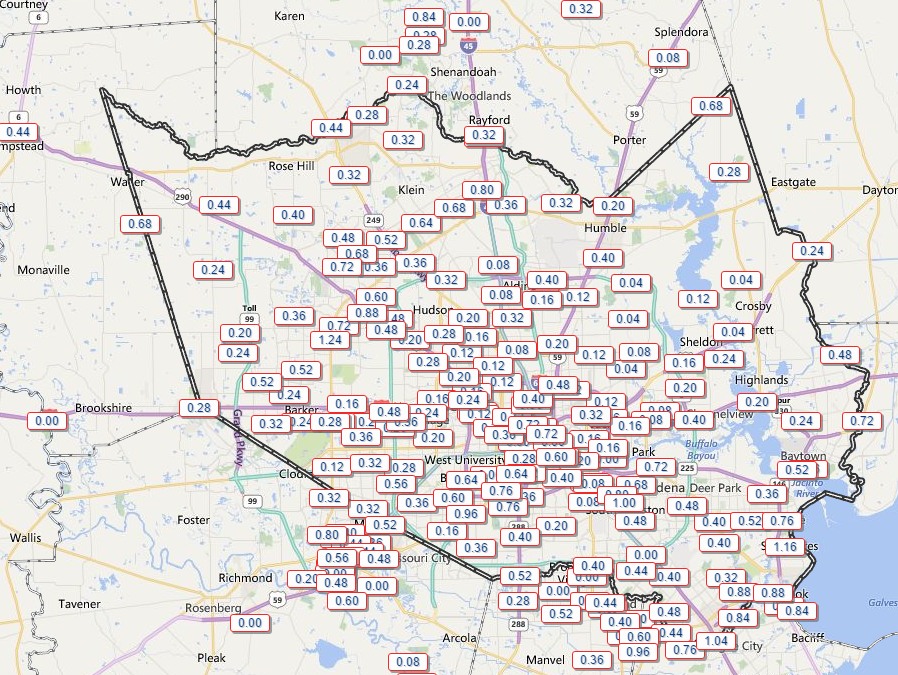
A line of storms moved through the flood-stricken Houston area this morning, and as expected generally dropped 0.5 to 1.5 inches of rain. The bulk of the system is now moving off into the Gulf of Mexico, and will clear out entirely by mid-afternoon. Although we could still see a few isolated showers this afternoon and evening, for the most part we’re pretty much done with rain for today and tonight.
Our attention then will turn to Thursday, when I think we will see a similar scenario play itself out. That is a line of storms will develop over northern Texas shortly after midnight and then move down across the eastern half of the state. Best guess at this point is they reach the College Station area shortly after sunrise and sweep through the Houston area during the late-morning hours or around noon.
That’s an estimate at this point, and so are accumulations. Right now I’d peg them about at the same amount as today’s, with 0.5 to 1.5 inches, but that’s premised on the storms weakening a little as they come down through the state, as the did today. We could see a little but more depending on how the atmosphere recharges after today’s system.
I’ll take another look at the forecast for Thursday in a post later tonight, to see if the outlook above is on the right track. For now enjoy a reprieve from showers this afternoon, and we can still look forward to drier conditions on Friday and Saturday.
Posted at 1:30pm CT Wednesday