As expected a line of showers and thunderstorms is moving down through Texas this morning, and it should reach Houston by the mid- to late-morning hours.
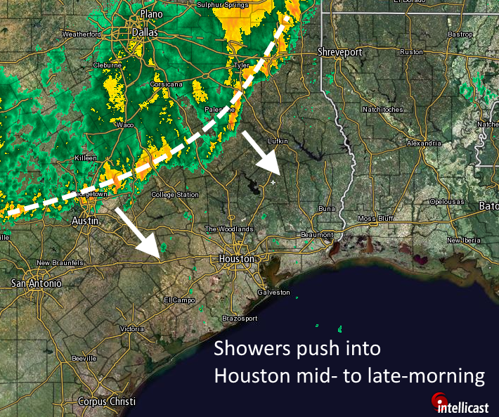
This line is generally producing about 0.5 to 1.5 inches of rain as it moves toward the coast, and the good news (if there is any) is that the system has generally moved at a pretty good clip. This means the threat of slow-moving storms is lower. Although we can’t rule out some isolated areas of 3 inches or more, I think for the most part people will see about 1 inch of rain. After the system moves through, later today and tonight, we should see some scattered, but potentially intense, thunderstorms pop up as we saw on Tuesday afternoon and evening.
Most bayous should be able to handle rains like these, but for neighborhoods that remain under water this rain will nonetheless be most unwelcome. The National Weather Service has kept a flash flood watch in place through this evening.
It looks like a similar (or perhaps less) amount of rain may be in the cards sometime on Thursday as a cold front moves through the area and off the coast by the evening or late evening hours. After this we will finally see drier air move into the Houston region, from north to south, on Friday. This will give us at least a couple of days of respite.
WATERSHEDS
According to the Harris County Flood Control District, here is some information on the most sensitive waterways in Houston this morning.
- Cypress Creek (entire length, creek has crested and falling, but remains well overbanks)
- Little Cypress Creek: creek is back within banks
- Willow Creek: creek is back within banks
- Spring Creek: creek is overbanks from Kuykendahl downstream to San Jacinto River with significant flooding along the Montgomery County side of the creek
- South Mayde Creek: Creek remains overbanks on the upper and lower ends
- Cypress Creek Overflow: Overflow of Cypress Creek into Addicks continues across western Harris County, but is lessening. Still large areas are still inundated from the Waller County line to east of Katy Hockley Rd
- Addicks: pool is now 100.6 and rising. Forecast to reach 102.3. HWY 6 is under 2-3 ft of water and forecast pool may put water into streets in the Bear Creek Village subdivision. HWY 6 will remain closed for many days
- Barker: pool is now 93.2 ft and rising. Forecast to reach 96.7 ft which is flooding streets in Fort Bend County. Streets may flood in Harris County also.
Posted at 6:50am CT Wednesday
Eric,
I am in Austin traveling home this am down 290. Can you see what the rains look like along that route to Grand Pkwy then on to The Woodlands? Any advice would be greatly appreciated.
If you can wait until later this morning that would be better. There’s the potential for heavy rain from 9 am to 11 am in this corridor.
Thank you so much!!
F
Hi Eric! A buddy of mine recently made me aware of your forecasting and I’m glad he did! I love the straight to the point perspective you provide. It is such a refreshing departure from the typical media forecasting/coverage that is designed to create panic so people stay glued to their tvs to bolster ratings and advertising $. Excellent work!!
Thank you Joe! And thanks to your friend for spreading the word — that’s the best compliment you can give.
I know this might sound bad, but I’m secretly hoping for some more street flooding. I don’t want it to get into anyone’s home or business, but if it could just flood the highways and give everyone another day off, I’d be okay with that.
That does sound bad, honestly, with thousands of homes flooded during the last three days.
About how long will the storm last once it hits? Thanks for the great work.
I am glad to find this site too.
I guess the community west of the Barker reservoir needs to leave town 🙂
Eric –
On the NEXRAD display, I noticed a thin green bow passing from NW to SE ahead of the storms. I often see something like this, but smaller, coming off the coast back towards Houston and guessed in these cases it was a sea breeze front. What could it have been today? A dry line?
Send me a link to the display, please.
https://www.wunderground.com/weather-radar/united-states/tx/houston-galveston/hgx/history/?date=2016-04-20
Eric –
This is the best I could do. You can only see it briefly here, you really need to shorten the time frame and zoom in a bit to see it.
If it is moving inland during the afternoon, then it probably is the sea breeze. I couldn’t make this out well enough to determine that, however.
I know, you can’t zoom the historical data.
It was actually out in front of the storms, moving towards the coast, maybe 15-30 minutes ahead.