The Astros weren’t the only winners on Thursday. Some folks saw actual rain yesterday too. The jackpot winners came in about three different areas: Dickinson in Galveston County, Fresno and Sienna Plantation, and just south of Sealy. There were a few other spots south and west of the Houston area that did okay as well.
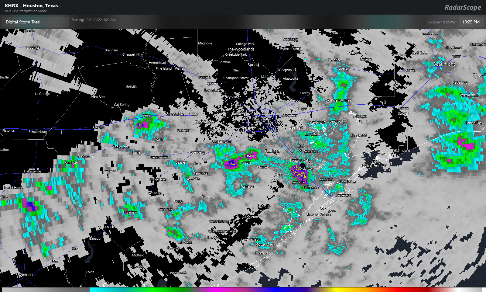
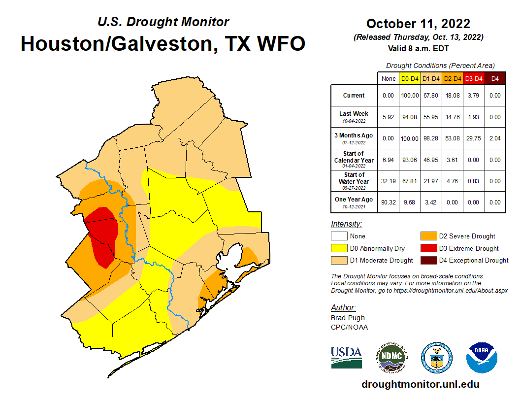
The highest measured totals I could find were near Dickinson (3.16″), Southfork (2.04″), and La Porte (1.96″). Yesterday’s Drought Monitor update underscored our need for rain, as drought coverage expanded by another 12 percent in the Houston region.
The good news is that we have more rain chances coming. The bad news is that these will likely do little to alleviate the underlying problem.
Today
All in all, today should be decent, albeit hot. The front has cleared most of the area, and we have slightly lower humidity in place now, but that drier air with sunshine will allow temperatures to efficiently heat up. Someone should hit 90 degrees today, but most of us will top out in the mid to upper-80s. A shower can’t be completely ruled out south of the city toward Matagorda Bay.
Weekend
Saturday looks to be a fairly uneventful day with sun, clouds, warm and more humid air, and just a very, very slight shower chance. Temperatures will warm from the 60s into the upper-80s to near 90 degrees or better in spots.
Sunday looks a little bit more interesting in terms of rain chances. I think most of us will see no rain, but there will be some neighborhoods that will host a shower or storm on Sunday. We’ll go from near 70 in the morning into the mid-80s, if not upper-80s by afternoon. I’d expect the shower chances and some additional clouds to hold temperatures down a degree or two relative to Saturday though.
Monday
Alright, our much ballyhooed front is still expected to arrive here in Houston on Monday. It’s still a bit too early to get too cute on timing, but I would expect the best chance of storms later in the day or evening, followed by gradual clearing late Monday night or early Tuesday. Clouds, showers, and the front should combine to keep our temperatures from warming much beyond the upper-70s on Monday.
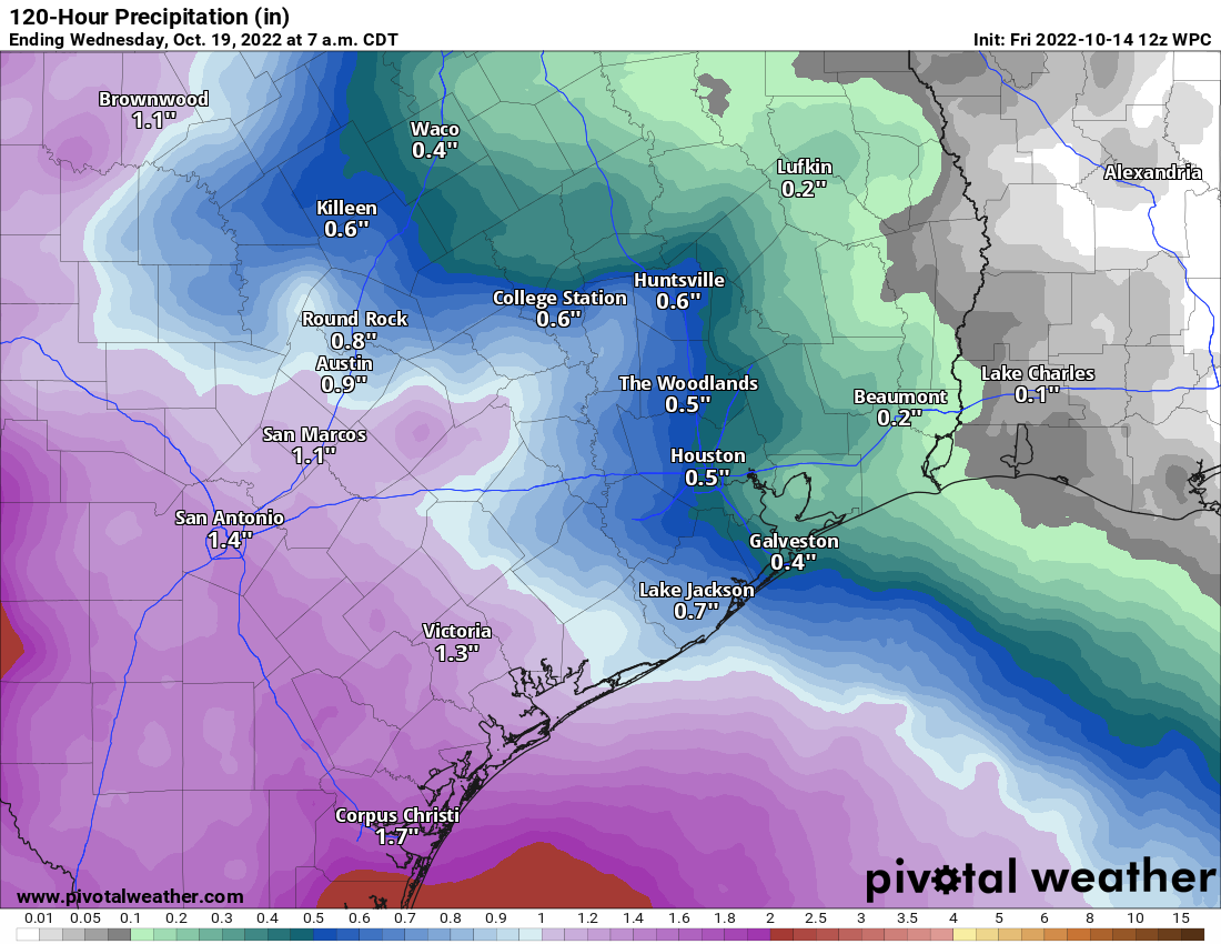
Rain totals are likely to vary, and because of the relatively progressive nature of the front, we will probably see a half-inch to three-quarters of an inch or less in most areas. This will certainly help take the edge off a bit given recent dryness, but it will do little to actually dent the burgeoning drought in our area.
Rest of next week
The Tuesday through Thursday period next week is being delivered by Yordan Álvarez, because it’s a home run. Expect three days of sunshine, low humidity, and cool, crisp autumn air. Highs will be in the low-70s, cooler perhaps on Wednesday and warmer on Thursday. Morning lows? Yeah, we have a shot at 40s.
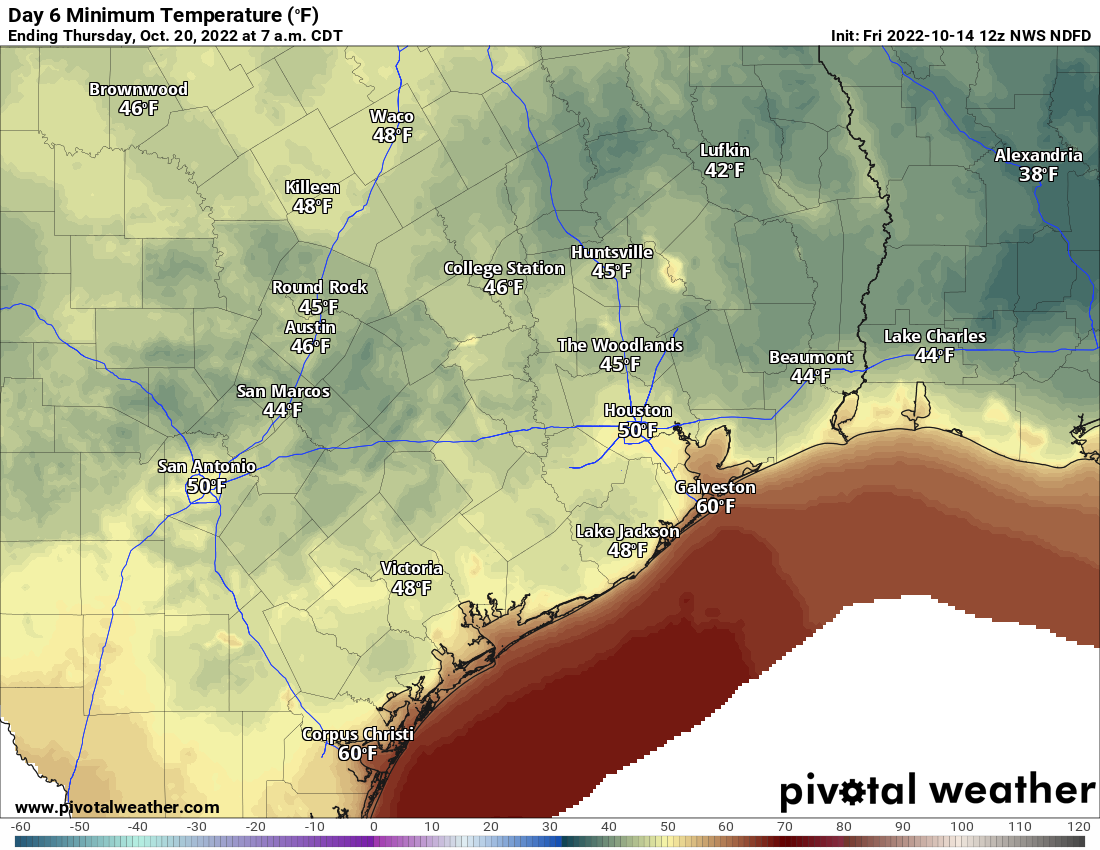
Expect 50s area-wide next Wednesday, Thursday, and Friday mornings. Much of the area will probably be in the 40s on Wednesday and Thursday morning. Beyond that, we’re probably looking at a warm up next weekend into the week of the 24th. More on that next week.

Happily surprised to see over an inch of rain in the rain gauge when I got home from work yesterday afternoon. Must have happened early in the morning because everything else was dry.
What’s the weekend look like in Seattle for the Astros? It ain’t over ‘til the Fab Cuban Swings.
I saw two areas of soaking wet road near the house on my way out for an event yesterday evening. 0.0″ in the rain gauge at the house 🙁 Love the Yordan Álvarez allusion
I got about 0.25 inch of rain yesterday, morning, on the east end of Galveston. Go Astros!
FYI, its just Sienna now. They dropped the plantation part a while ago.
Ty!
We will take FALL while we can get it! Hopefully there will be more on the way!
literally, my heart jumped when I read “40’s”. being just inside of Galveston County, I know it won’t get that far here, but oh, that it would be in the forecast at all. Come On, Fall! (and Go Astros!)
FRONT-FRONT-FRONT-F R O N TTTT!!!!!!!!
I can’t wait for next week’s front! Thanks Matt! Jesus loves you and saves (John 3:16)!
Hoping the weather cools down next week going to the Renfest.
GO STROS!!!!!!!
1.71 on our rain gauge in Sugar Land on the edge of Missouri City. Yay!!
I was in a warehouse in Pearland last night and the sound of the rain was quite impressive. The rain was heavy enough that we cut our evening short to get home in case the roads got too rough to travel. We did hit some splash points on the way home, but the rain did not, unfortunately, follow us home to Friendswood