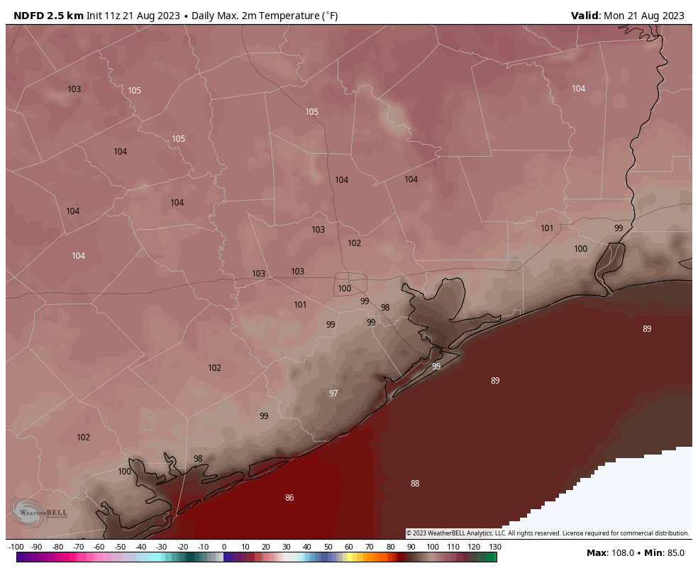
Sunday was blazing hot as upper-level high pressure continued to bake Texas. Nearly all meteorological sites across the region broke daily high records, in some cases smashing them. The city’s “official” measuring station, presently located at Bush Intercontinental Airport, reached 108°. This is one degree short of the city’ all-time hottest temperature across nearly 150 years of records, 109 degrees. This mark was recorded on August 27, 2011. Here are some other results:
- Houston-IAH: 108° (1 degree short of all-time high, reached four other times)
- Houston-Hobby: 107° (broke daily record high of 101°, set in 1999)
- Galveston: 97° (tied record daily high from 1995)
- College Station: 112° (tied all-time record high, set Sept. 4, 2000)
- Sugar Land: 107° (broke daily record high of 101°, set in 2018)
- Tomball: 110° (broke daily record high of 101°, set in 1999)
Our eyes now turn to the Gulf, where a tropical disturbance has a decent chance of flaring into a tropical depression or storm today, before moving into South Texas early on Tuesday. I fear we will be looking longingly at the system, because its winds and waves won’t be severe, but its rains definitely beneficial. The best accumulations will all be south of Corpus Christi, although the southern Houston area may see some stray showers today and tomorrow. See below for much more information about the Gulf disturbance.
Monday
Today is going to be very hot again, although temperatures probably will be a few degrees lower than Sunday’s exceptional highs. Skies will be mostly sunny this morning, but we may see some clouds developing today. In response to the tropical system, our winds will become more easterly, perhaps gusting to 20 mph later today. These winds will exacerbate fire conditions, and a red flag warning is in effect for the combination of strong winds and high temperatures.
Will it rain today? Probably not. Some isolated areas probably will see a decent soaking, but all of the organized shower activity should be far to the south of the Greater Houston region. Rain chances are probably on the order 20 percent today and tonight for coastal Houston, and closer to 0 percent north of Interstate 10.
Tuesday
Rain chances will peak on Tuesday, at perhaps to 30 or 40 percent south of Interstate 10, and maybe 20 percent north of the freeway. This day should also be slightly cooler, with highs in the 90s for areas closer to the coast. It’s still going to be hot, though. Skies will be partly to mostly sunny.
Wednesday
A hot day, with highs in the low 100s for much of the region and mostly sunny skies. Rain chances? They’re long gone.
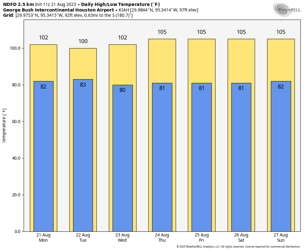
Thursday, Friday, Saturday, and Sunday
Unfortunately this period looks to be extremely hot, with high pressure building more directly over Texas. We’re talking highs in the low- to mid-100s, so akin to what the region experienced this past weekend. Rain chances will be on the order of about 10 percent each day.
Is there any relief at all in sight?
If you’re wondering about cool fronts and plentiful rainfall, alas, the answer is no. However at this point the ridge of high pressure does look to back off some next week, and that should take some of the top end off of the high temperatures. It should also allow rain chances to creep back up a little bit. We’ll see. This summer has been brutal, and will continue to be for some time.
All about the Gulf disturbance
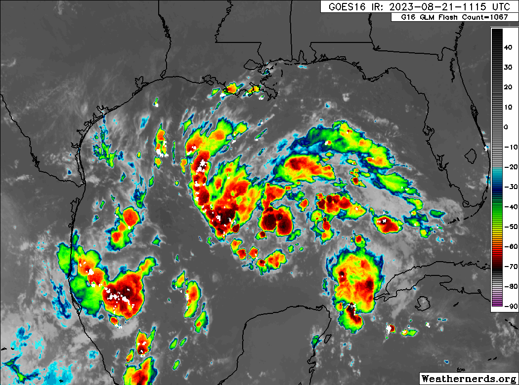
Now let’s talk about the Gulf of Mexico. This portion of today’s post comes via The Eyewall, our companion website where you can find comprehensive coverage of hurricanes. This morning, we have seen no real progress toward better organization overnight from the tropical wave, Invest 91L, in the eastern Gulf.
Just as a quick reminder: Invests are really just meteorological classifications given to tropical disturbances so extra data can be compiled about them; literally “an area of investigation.” There’s no strict definition, but they go from 90 to 99 and then recycle again. In the Atlantic we use “L” as an identifying abbreviation. The East Pacific is “E,” West Pacific “W,” etc.
Anyway, 91L has a broad circulation this morning but does not appear to be tightening up any as of yet. The good news is that this system only has about 24 hours left over water before it comes ashore in South Texas. The most likely outcome at this point is an approach just south of Corpus Christi or north of Brownsville.
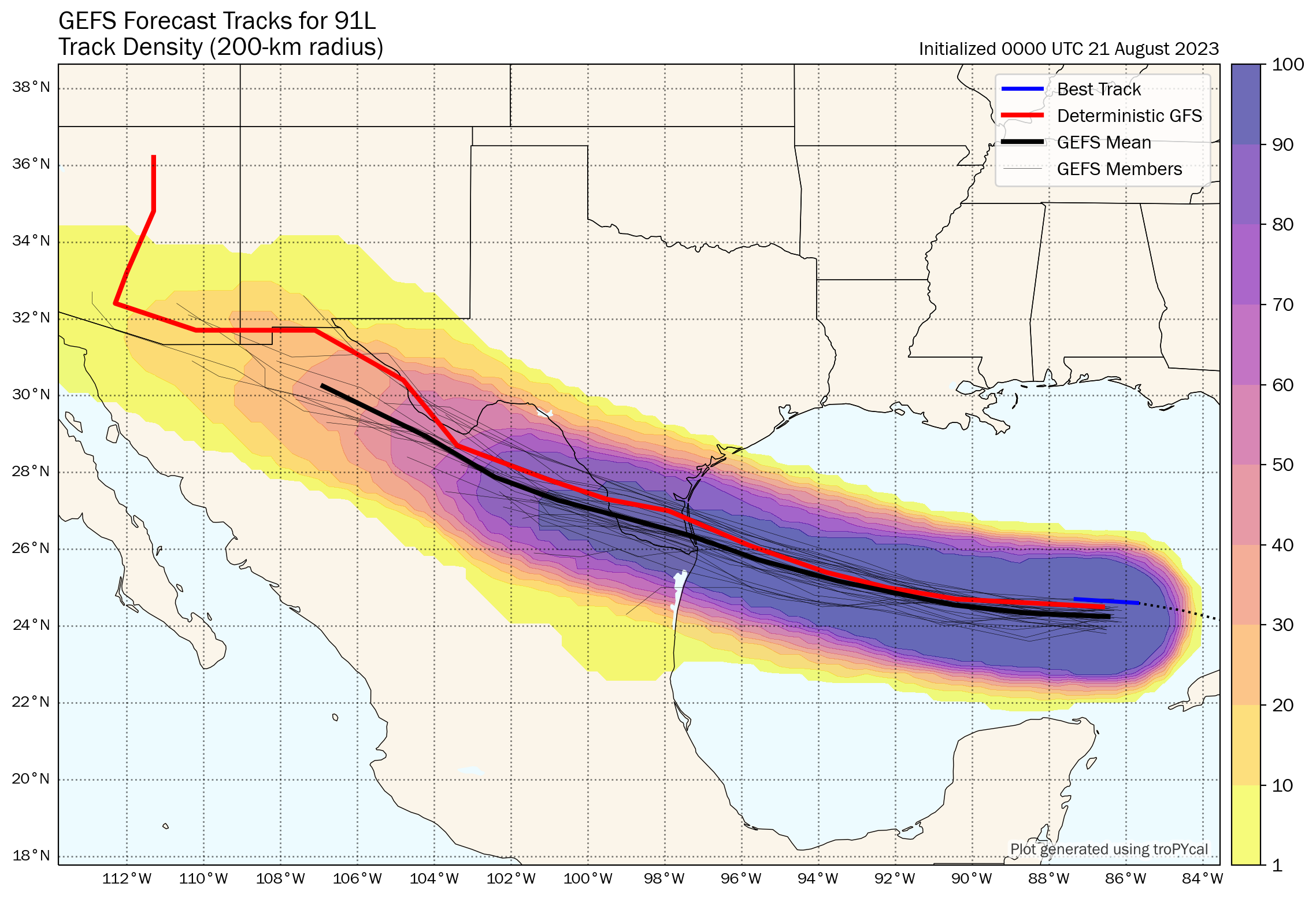
Given that we have 24 hours left and given how this thing looks on satellite, my hunch is that if we see this upgraded we may skip the formalities and go right to a tropical storm. The next name on the list would be Harold. At worst, this would probably become a low-end tropical storm (45 to 55 mph maximum sustained winds, mostly in heavier rain bands and over water).
More importantly, this will be a rainmaker for Texas. The entire state desperately needs rain.
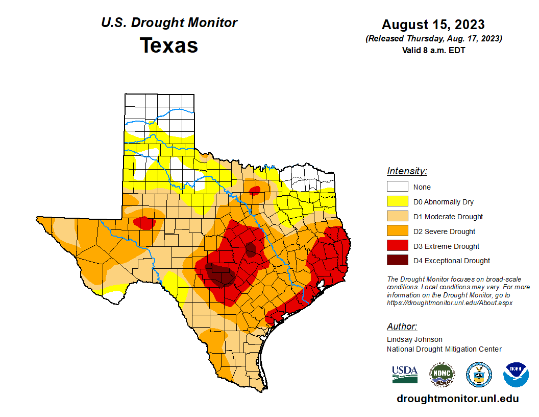
East Texas and the upper Texas coast are in extreme drought, with pockets of exceptional drought in Hill Country northwest of San Antonio. A quick moving tropical system would be virtually 100 percent positive in Texas right now. This will help. Rain totals of 1 to 3 inches with higher amounts are expected for South Texas, mainly south of Corpus Christi into the Rio Grande Valley and west toward Laredo. Northern Mexico will also receive healthy rains from this.
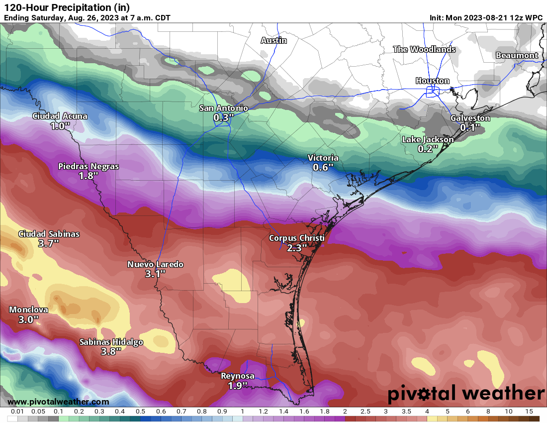
While this will not end drought for South Texas, it will greatly help. Unfortunately, the hardest hit parts of the state are expecting little to no rain this week, meaning drought and fire danger will worsen.


Yep, August in Houston is hot. I’m not sure why people have to belabor this every day, like it’s usually 65 degrees this time of year?
Because we normally have maybe 5-7 100 degree days a year and not 20+ in a row with zero rain for months?
exactly!
I agree. Yes, Houston summers are generally miserable, but some are measurably worse. This is one of them.
It’s Monday morning and maybe still in a stupor so you can be forgiven for being unaware that you made this comment on a website that talks about the weather.
go out all day and wait at the bus stop in the “normal” summer weather conditions then
hand claps!
Augustus swooping in to save us with the ex se intellegitur. Thanks man.
You must not have been here long. From 1950 through 1979 – three full decades – there were a total of 34 days when temperatures reached or exceeded 100 degrees F at the Hobby Airport measuring station, according to the website ExtremeWeatherWatch. That’s right – a total of 34 days over a period of 30 years. There wasn’t one day in the 1970s – 1970-1979 – when the temperature reached 100 degrees in Houston. We’ll end up with more than 30 days with 100-degree-plus temperatures this summer alone. The reason why people “belabor” this is because the average daily high temperature in the peak of the summer (August) was 94.3 degrees, according to the 1983 Rand McNally Places Rated Almanac. Days with 100-degree temperatures were once very rare in Houston. The takeaway: It’s getting much hotter, and quickly, too.
Huh. Wow. I wasn’t born yet at that time – while this year is clearly exceptionally hot even by recent standards, I hadnt realized that 100+ days were that rare in recent times.
It’s normally too humid in Houston to get to such high temperatures. It’s feeling like Phoenix out here instead of our normal humid subtropical climate.
I’m in my early 50s. There was a contest in the early 80s to guess which day Houston would hit 100 degrees because it didn’t happen that often….usually a couple of times a summer. I’ve definitely noticed our summers have gotten warmer and our winters milder.
To be fair there was ten days at Bush Airport that temperatures hit 100 degrees or more in the 70s. Six of them occurred in 1978. However the 70s was a much cooler decade overall even at Bush Airport.
This death ridge is something else.
One day my home weather station will have something else to do other than overheat.
“Is there any relief at all in sight?”
The answer is always no. Any possibility of change 10 days out always fizzles out. Rinse and repeat.
This seems like at least the 5th week in a row where the start of a week had good rain chances 7-10 days out only to fizzle to nothing as the target days drew near. I’m starting to think the weather models have been taken over by a misanthropic chat bot who likes toying with us.
this happened a LOT last year during summer as well. The programs are good at giving false hopes. Not sure they are very reliable because people start to doubt them. Then when we have a real serious storm, no one’s gonna believe it. I think whoever is maintining these models or programming needs to take this in consideration. Too much probability of storms. Too much confidence of rain.
The accuracy and precision that far out are never good. Too complex of a system for what we can predict. Same as with hurricanes for example. Just too many variables to have a reliable model. Even same day predictions go sideways frequently. It’s a forecast not a schedule ;-).
At this point I’ll take the “dome”. One gets the feeling that if the high pressure slides off, the Gulf would become a batting cage for the queue of disturbances coming off Africa.
I’ll take the other side of the coin – the dome keeps things hot at night, hotter during the day and makes for a miserable time for months.
Tropical systems come and go and do not necessarily sit on top of us for months. Plus, we’d have more variety in the daily forecasts. At least, there would be different names for the storms. The heat dome is just the heat dome.
Yes, this! Why is the assumption that if anything tropical forms in the Gulf, it’s automatically another Harvey?
Right Kay. Instead it could be another Ike or Allison. As if those would be good.
Dome or tropical system? It’s a gamble. Been here in Houston over 60 years. Most tropical systems are very beneficial but some are devastating for many, especially as it relates to flooding. In both cases if they stay around for too long nothing good comes of it.
“Hope smiles from the threshold of the year to come, whispering ‘it will be happier’…” — Alfred Lord Tennyson
I have to admit it’s getting harder to find encouragement from our weather history but in todays semi-daily dose of hope from Glenn we flash back to October, 1984 when Texas experienced it’s wettest October in history and crushed the multi-year ongoing drought. With a little luck we won’t have to wait until October this year to end this drought and heat wave…
Let me guess – Tennyson said this in 2019.
In other words, we ain’t gettin’ nuttin, folks.
While I appreciate the honestly of the forecasts, each update without any sign of the heat relenting (and I mean to the 90s – I know we aren’t in for any real cool weather for awhile) is increasingly soul crushing. From a curiosity standpoint, what would it take to break the heat dome effect? It seems to be self-sustaining and essentially invulnerable at this point.
I’m not sure it will go away anymore. Makes me think we will have a miserable and hot winter too.
i prefer hot winters! our landscapes will stay green all winter and they will be comfortable. The problem is that as weather gets more extreme with the planet’s warming, we will get lower lows more often and higher highs more often. That dome is here to stay but it may also bring lows like 2021 which causes a LOT more problems for Houston. Also expect a severe hurricane/tropical storm next season. Another Harvey soon. These events are happening more often.
Maybe one day we’ll learn to not build in flood plains, remove wetlands and forests that hold more importance than is given, and generally build more responsibly so that Harveys don’t always have to be repeated.
While I agree that building in floodplains (particularly 100 year floodplains) is a bad idea, I strongly disagree with the sentiment that the removal of wetlands, forests, and plains made a significant impact on the flooding. Rainfall totals for Harvey were 40-60 inches, and the average annual rainfall in Houston is ~52 inches; having 77-115% of your annual precipitation fall in a four day span is going to wreck havoc regardless. Would porous surfaces absorbed some of that water? Yes. Would it have made a significant difference? IMO, no. From my vantage point during the storm (Rice Military area) while I did see massive flooding from Buffalo Bayou, I was also impressed at how fast the bayous drained once it stopped raining. 24 hours later they were well within the banks (although I understand many areas were still underwater for significantly longer periods of time)
The Harvey flood would not been as destructive had Houston ignored the advice back in 40’s/50’s to not allow population of Houston to exceed 400,000. I found out after we moved to Pearland that the we now and about 4-5 Thousand others live were once rice farms and a nature preserve. The elevations when Houston was first settled was in 20-30 ft. Range. Not ideal for such massive development.I’m definitely not a genius, but I do like to read history, my Bible, and politics. Our biggest problems Iin life ,we spend too much time studying history and politics and not nearly enough time studying GOD. and His ,word to us.
Tree routes break up the soil allowing better drainage, the leaves soak up the carbon and provide shade, trees make us all feel a lot better, wetlands provide habitat for wildlife and act as buffers from storm surges along the coasts, concrete adds to the heat dome coupled with the energy used to manufacture it – not to mention the gravel dredging decimating the river banks. We could and should do a lot better to protect the environment we all have to live in.
The only bad thing about that is warm winters may make the northern gulf even warmer.
It is absolutely soul crushing, demoralizing, and depressing. I am praying the long ranged forecast for the winter will stay true at cold and wet this year. There has to be some kind of hope!!!
Fortunately there is a higher chance for a wetter and colder winter this year because of El Nino. Back in 2009 we were going through a very hot and dry summer with D4 drought conditions along the coastal counties. The following fall brought an abundance of rain plus one of the coldest winters this area has seen on average. The drought was completely destroyed. The fall and winter of 2009-10 was an El Nino event. I’m not at all saying that there is a 100% correlation there, but we tend to see wet falls and winters during El Nino periods historically. My point is that there is indeed some hope in the not to distant future. 🤞🤞
Why is the temperature gradient between IAH and Hobby and Sugarland disappearing? Per previous records, they used to the almost 10 degrees apart and now it seems like it’s one one or two
Not sure the exact reason here, but we had the same thing with the weather stations in Austin and the answer was soil moisture and soil type. One weather station was sitting on more clay soil which takes a lot longer to fully dry out. Wetter soil lowers the temperature a little bit. We haven’t had rain in so long that all the soil everywhere is dry dry dry and now the temperature readings are the same.
That’s a good theory, thanks Chris.
Urbanization.
Part of it is that the Gulf of Mexico is a lot hotter than average, which brings up the temp at Hobby relative to IAH.
It honestly feels like this dome will never go away. It hasn’t all summer, what could even get rid of it at this point?
I think I remember reading here during last year’s early-summer drought that Texas droughts (and high pressure systems more generally) are often ended by tropical systems.
Eric – echoing many other comments here, I’m really curious as to what could make this pattern change at this point, where the blocking high will move enough to allow texas to have a change in weather patterns. Will it take waiting until October?
It is very possible we may have to wait until October or late September for this high pressure dome to finally break and shift towards the south finally allowing rain and cooler temperatures to return again. In 2011 we didn’t truly cool off until October. We didn’t start seeing widespread frequent rains to return until November that year. Fortunately we are currently forecasted to see above average rainfall and cooler than normal temperatures this winter. Hopefully that comes true.
At this rate, I think Eric and Matt could really simplify the forecast by just stating a one line forecast: “We’ll return in October when there is a change in weather…”
We’ve had a Mediterranean summer and SoCal had a hurricane (+ earthquake). At this rate of weirdness, we’ll have another winter with more freezing precip.
I agree, Im expecting the worse… I didnt in 2020 and so much destruction happened with the winters after that. It was shocking but we need to be prepared for this to be the norm. I hope Im wrong!
I was shocked that my thermometer was reading 94 at 9:30pm last night. Temperatures in the mid-nineties at 9:30 at night. This is really depressing.
I believe that the all time high of 109 was reached in 2011 but also in September of 2000, and that the high of 108 had been reached in the early 1900s, while during the hottest summer ever (1988) Houston’s highest temperature was just a little more than 100, and, even during the extreme heat wave of the 1930s, Houston didn’t above 104 or 106. The 1930s was perhaps the hottest summers ever.
What do you mean “hottest summer ever (1988)”. I was a kid in Ohio in 1988 and yeah there was a tremendous heatwave and drought that year. But that does not make it the “hottest summer ever” everywhere. It was the hottest THERE, but not the hottest everywhere. 2011 is king (so far). 2022, 1998, 1980, 1954 were incredibly hot in Texas as well. Globally, the hottest summer ever was 2019. 2023 will likely break that record.
So, what do you mean with your statement above?
Scott
I would imagine Jason…posting on a Houston-oriented weather site…was referring to Houston all-time highs. And like probably everyone commenting here other than you…has absolutely no idea what the weather was like anywhere in Ohio in 1988.
Exactly what statement in Jason’s comment led you to believe he was talking about the hottest EVERYWHERE?
I went outside last night at 8:30pm to check on plants etc before bed and it was still 95. Un-effing-believable.
“well at least it keeps hurricanes away” is what I might say in a normal summer. This year I’d for sure take a cat 1.
I hope TS Hilary dumps some rain on Lake Mead at least.
Little circulation, lots of heat. Stagnation.
Starting to feel like the edge of the Permian.
(at least the continents are spread out – that counts for something 🌎)
Maybe we should talk to the author of climate to give us strength to endure.
Please water the trees and shrubs in your yard. I’m seeing a lot of stressed and dying trees in yards. Not only is it sad when a tree dies, but there is the practical aspect of paying to have it cut down or waiting until a tropical storm brings it down for you, possibly onto your house.
Root feeders are great for tree watering. Ours are many years old but a fast Google search shows they are still manufactured (pricey to these eyes, but cheaper than dealing with a dead tree). It’s a steel stick with water holes at its tip; ours wiggles into the ground about 12-15″ down–out at the dripline of the tree. Our tree guy said to water in a circle around each tree, staying at the dripline (as far as branches extend) starting at the “top” and then going in a circle at the quarter marks (so 12, 3, 6, 9 on a clock face). The water goes straight into the ground and that encourages the roots to reach down for the water instead of reaching up and spreading, which can cause all kinds of havoc in the lawn and/or foundation. With the ground rock hard (and that’s with regular watering!), it helps to turn on a light flow to the root feeder as you’re trying to get it into the ground. Don’t add plant food, though; you don’t want to encourage new growth when a tree or plant is already water stressed.
I agree with Slavic Mama,
Don’t assume your small, medium, or even larger trees do not need water at this point in the drought. My grandpa used these steel sticks with water holes to save many of his drought stressed trees surrounding his farmhouse out in the country many years ago. I should know since I was the grandson who helped him out. It was absolutely fascinating to do this as a kid. On a more somber note, I REALLY WISH THE CITY OF HOUSTON WOULD GIVE A 1,000 OR 2,000 GALLON discount for all the homeowners willing to spend money during a drought to save the trees and tree canopy of our city. Most people would gladly accept such an offer. Mayor Turner, are you listening? Thanks so much if you are!!!
Do the weather models show the Houston area as a DESERT in …say… 50 years?
We should find a way to use the heat. Every time humankind finds a use for something, it becomes scarce.