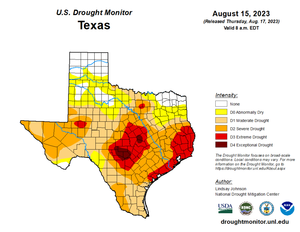
Well, this is not great news I’m afraid. On Thursday the US Drought Monitor upgraded much of the Houston area to “extreme drought” conditions, with the remainder of the region in a “severe” drought. All one needs to do is look around at the area’s brown grass, or the sagging leaves on trees, to know that it is really dry out there.
We had been holding out some hope that a tropical system moving into the Gulf of Mexico this weekend would provide some relief. Unfortunately, the models are now increasingly in alignment that a potent high pressure system over the central United States will push this Gulf disturbance far enough to the south that it will probably not bring widespread, meaningful rainfall to our region. This forecast, certainly, can change. But as of now I would set your expectations low.
Friday
Another very hot day for the region. Look for high temperatures in the low 100s, with ample humidity, sunny skies, and only a light southwest wind. Overnight lows will provide only a bit of relief, dropping down to around 80 degrees.
Saturday and Sunday
The weekend will bring more of the same with a high pressure system dominating our weather. Look for highs in the low- to mid 100s, which is to say that some inland locations could get up to 107 or 108 degrees for an hour or two during the afternoon. Yikes. For coastal areas, there is perhaps a 10 percent chance of rain on Sunday afternoon.
Next week
Our forecast for next week remains dependent on the track of the low pressure system that will be zipping westward across the Gulf of Mexico. It is expected to near the Southern Texas coast by Tuesday, most likely as a tropical disturbance, but there is about a 30 percent chance of it becoming a tropical depression or tropical storm according to the National Hurricane Center. However, I would not fret about strong winds or waves. This system will be mostly beneficial, in the sense that it will bring a decent amount of rainfall to some parts of Texas.
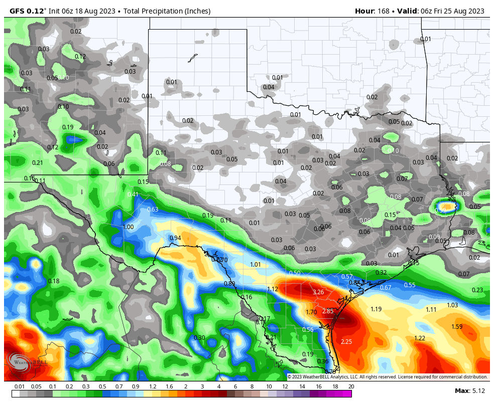
For now, and again this remains subject to change, the preferred location for 2 to 6 inches of rainfall is Corpus Christi and the state’s Coastal Bend. North of Matagorda Bay, rain chances start to diminish, although coastal parts of the Houston area are still likely to see some modest showers. I would peg rain chances in Houston at about 50 percent on Tuesday, and some increased cloud cover may hold high temperatures to the mid-90s. However, at this time, it does look like we are going to miss out on significant drought relief. If this forecast changes over the weekend, we’ll definitely update you.
After a brief reprieve in temperatures, we can expect highs to jump back up into the low 100s later next week, with sunny and hot conditions heading into the weekend.
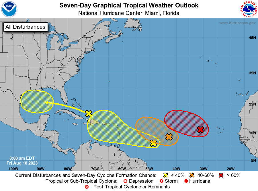
Tropics
The tropics are starting to really heat up, with Hurricane Hilary setting up to bring a potentially extreme rain and flooding event to parts of the deserts and/or mountains in California and Nevada; and increased activity expected in the Atlantic to end the month of August. You can find full details about all of this on our sister site, The Eyewall. For now, beyond the disturbance mentioned above, there are no other specific threats to the Gulf of Mexico.


For a number of years now, I’ve suspected Houston would become the next Detroit. I think I was wrong. Houston is becoming the next Saudi Arabia.
I lived there (Dhahran) for two years in the 80s, and this is just like that. Slapping you in the face temps/humidity.
As a Detroit implant…don’t do it!!
Lol! I’ve been referring to Houston as Houtroit for the last 5 years. You’re right about the Saudi Arabia part too.
That high pressure likely won’t move until October…..Keep sprinklers handy a couple more months.
Eric, could you speak to when that high pressure ridge causing our heat dome may loosen up? Anyway to know/guess at this point? Are we looking at weeks, or months???
Yes Eric please give us some hope! It feels like it’s never going to be cool again…
Stay inside until November to be on the safe side.
How much might make it to Canyon Lake? We’re very close to record lows.
To all 3 of yous, (typed in new york-ese)that sounds like the way to go. Until this ridge breaks down completely, welcome to West Riyadh.
We are allergic to rain this summer.
This is a repeat of 2011. Massive foundation damage to homes from earth movement and busted pipes everywhere. Water that foundation!
Could Hillary showers get caught up on the edges of these central high pressure systems and get thrown our way?
It is pretty telling that we’re looking forward to a possible tropical system crashing into us next week. Everything in moderation but we’ve overdone it on the heat for sure.
Thanks for covering Hilary on The Eyewall.
“But as of now I would set your expectations low”…dang…sort of “rains” on our parade, doesn’t it?! I know…bad joke…
Subject to change: You bet it is. Until genesis begins y’all can throw these models out. Banking on circulation to form farther north than expected. Bringing the whole caboose right into upper TX coast.
why is this high pressure system here? even Phoenix and El Paso are getting rain.
The reason why the Southwestern US is getting rainy weather is due to the annual monsoon season occuring between June and September.
The gulf coast is also rainy in the summer. Or used to be…
A knee to the south side, isn’t it Ian?
It hasn’t been hot everywhere nor dry. Plenty of the US have experienced a cooler than normal summer. The West have received abundance of rain with record breaking snow pack and now will receive more beneficial rain; good for them. Everything is cyclical and we are currently experiencing this hot and dry cycle in this area. Hang in there, I prefer this than an Allison or Harvey.
I sure would appreciate it if that cycle would come so that the dry periods are in winter and the wet periods are in summer. Rather than two years in a row with extreme drought in summer.
Eric, my main concern with this system is the associated winds. I have resources working fires in SE Texas and the Western Pineywoods—can you give me any idea of how much this system could increase winds in these regions?
It’s 2023, we should have flying dinosaurs to ride and weather scientists who make it rain already
Well, the 45-day Accuweather app forecast for Houston moved the first sub-90-degree-high-temp day from September 4 all the way to September 23. Which really means that they should stop with these silly long range forecasts.
I like to call them INaccuweather. Because they’re not always so accu.
I always preferred Weather Underground.
I may have missed it. Could you, would you give some insight was to why the “heat dome” camped out over Texas? thanks
Joseph is the best pattern watcher on this forum! I’ll let him comment. My answer would be the jet doesn’t get to the lower states including TX in the summer….high pressure sets up and nothing to move it. Very stable unless a tropical storm from the GOM or a strong front from the west gives it a nudge. Joseph have you ever seen a year without the heat dome? If so what kept it away.
Look at the rainfall records for IAH. Steady raininess all summer.
sorry, typo in 2007 i mean
Thank you I really appreciate that DJ. I don’t pretend to be an expert but I have a huge interest in what makes the weather tick, so I do alot of research. I still have alot to learn lol. Everything you said about the jet stream and high pressure was pretty accurate. I also will explain the root cause of this a little bit. The Earth’s tilt causes the northern hemisphere to face towards the sun during the summer. The extra heat from the more direct sun angle shifts the jet stream into further northern latitudes. The temperature diffrence between the poles and the tropics is much less during summer than in winter. This is causes the jet stream to be weaker and move slower, which leads to stalled out high pressure and low pressure zones in various regions. This happens to be another year where we have been stuck under high pressure through the summer. I’ve never seen a summer before where there was no heat dome at all. However sometimes we end up stuck under low pressure for long periods of time during the summer. More so than high pressure. 2007 and 2021 were very wet summers around here because of a dominant low pressure pattern. I’m not exactly 100% sure what causes it however it seems like when the dominant upper level high shifts far to the north and west, that makes Texas more vulnerable to tropical activity. Often times when Texas is sitting under clouds and rain, the northern states bake under heat domes. La nina can increase our chances of rainy summers because of the lack of windshear in the gulf. That’s not a for sure thing though. Even during the summer the jet stream can be very wavy and inconsistent. I hope that helps a little bit.
Also the subtropical high that brings us our hot summer weather is caused by the sinking of hot air from the equator. The sun heats the equator more than anywhere else on Earth. This hot air rises and travels northward in the northern hemisphere. This heated air then begins to cool and sink between 20 and 30 degrees latitude causing the infamous subtropical high pressure belts around the world. This air compresses and heats as it sinks blocking clouds and rain from developing. This is why certain regions are deserts like north Africa and the middle east. We lie at about 30 degrees latitude here in southeast Texas. If it wasn’t for the Gulf of Mexico, all of Texas would be a dry desert. Anyways this high pressure belt shifts to the north in summer and south during the cool season. This is thanks to the Earth’s 23.4 degree tilt. Thank god for Earth’s tilt or else we would be stuck in summer forever lol. I feel bad for our neighbors at the equator. For more and better information on this topic look up global circulation and the Hadley Cell. YouTube has alot of great videos discussing this phenomenon for those of you that are curious about this subject.
Excellent discussion for the many here who have asked: why are we stuck under the Texas Ridge all the time.
It is interesting that Texas is often under low pressure in late spring and early fall, while the Southeast is under high pressure, but in the height of summer, it reverses.
I am hoping that it doesn’t rain when I ride my bicycle to work I am worried because I work in a bad neighborhood (Med Centre) and always have things stolen off my bike, so my waterproof bag could get stolen and I have to remember to take my rain jacket with me and not leave it in the bag and lose it as well. I hope that the dry weather stays, I love cactus plants, and I love the heat. Hopefully won’t be any hurricanes or tropical storms here this year.
I guess there’s a silver lining. If we don’t get rain soon there might be huge wildfires, mass arborcide and widespread property damage but your rain gear won’t be stolen so I guess it’s worth the misery.
Hey Roger Lodge. Don’t be such a grump. Jason contributes a unique and welcome perspective here. He likes to ride his bike. I get it. This exercise creates a nice breeze. Wishing for the weather to be some certain way is common. Unfortunately the weather doesn’t care a whit and will do as it does. So in the middle of ongoing heat and drought, reading about someone that likes it this way is just fine.
So where is the storm that is going to hit the west coast going to go? Will it follow the weather patterns and flow north over the high that is sitting over us, or will it go south through Mexico and back into the Gulf?
“Hope is the thing with feathers
That perches in the soul
And sings the tune without the words
And never stops at all.” ― Emily Dickinson
In todays semi-daily dose of hope from Glenn I would like to remind everyone of two things. The Gulf is extremely warm so it would not surprise me if this develops a little quicker than forecast. Secondly, the North and East side of any tropical system is usually the worst. A direct hit in Corpus may give us a little more rain than the models are currently forecasting a full five days out of a storm that has not even formed yet.
Hope springs eternal.
Emily Dickinson (The Maid of Amherst) was a recluse and probably never had to go outside to put up with Houston like weather.
sighing
atmospheric sargasso sea
♨️
Hobby Airport is done for hottest August, it all depends on the disturbance’s outcome if 2011 is shattered at IAH as well. Unfortunately it seems increasly likely.
It looks like it. It is currently running above 2011 at IAH, Hobby, and College Station (and likely Galveston too).
“..specific threats”
Surely you mean: specific hopes?
Agree!
If a last minute tropical depression forms right before landfall, there’s always a chance that the outer bands will circulate in such a way as to bring some of our areas a lot of rain. If the bands show any training lines, these lucky people could get some wonderful outcomes. We can watch with hope. Is the GFS always 100% correct? It would be nice if the rain field broadened to the entire area between Corpus Christi and Beaumont.
Last year a storm/wave landfalled about the same spot in south Texas. I don’t think it brought hardly anything to Houston then. But it eventually bring rain here when the remnants circled back into Texas from the desert southwest.
Where can I buy a space city weather t shirt? I like the logo and want wear it proudly.