I filled in for Eric all of last week, which feels like it was 25 years ago at this point. Between the profound changes to our daily lives and the lack of virtually any day to day change in our weather since then, it certainly has felt like a warmer version of “Groundhog Day.” Alas! As Eric has been discussing all week, changes are on the way. They begin today. And they continue next week. Break out the shorts. I explain below.
Today & tonight
Rain is falling this morning basically on a line from Columbus in the west to Conroe in the north. Some areas just west of The Woodlands have picked up close to an inch of rain so far today. We’re also watching a batch of storms between San Antonio and Victoria that will try and work across parts of the area this morning.
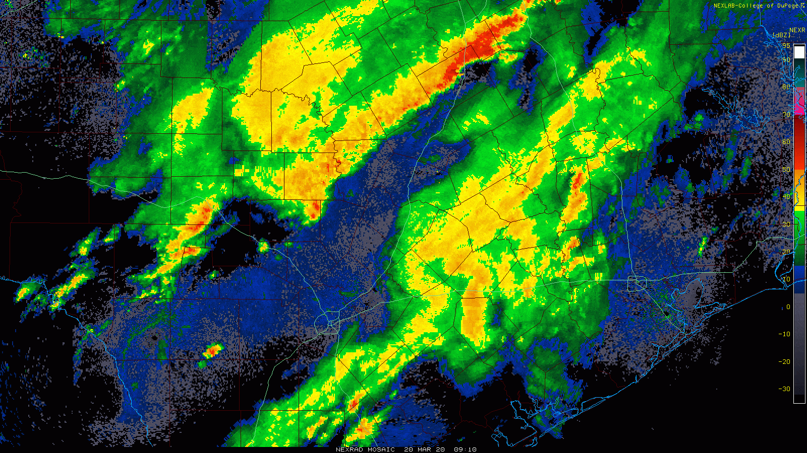
I think a good rule of thumb for the Houston area this morning: Rain will be most likely north or west of US-59. As we go through the morning and into this afternoon, rain will continue to creep south and east but a lot of the support for heavier rain and storms should sneak off to our east. This means while many of us will see some rain today, it will become less concentrated, more scattered, and less significant as we go into this afternoon, even with the front approaching.
Rain totals should be quite variable. Areas north of Harris County should see 1-3″ total today. For northern Fort Bend and northwest Harris Counties, expect an inch or so, give or take a few tenths. For southern Fort Bend and southeast Harris Counties to the coast, some folks may be lucky to see even a quarter-inch of rain from this.
Outside of minor street flooding issues north of the Houston area where the heaviest rain falls, we do not anticipate any real flooding problems today.
Timing-wise: The shift to offshore winds should move through northern and western suburbs soon and before midday. It should pass Downtown Houston around early afternoon and reach the coast by late afternoon. Once the front (or pre-frontal trough) passes, we’ll see temperatures stop rising. So that means there will be a wide disparity in temperatures today. We’ll drop from the 70s into the 60s in far northwest suburbs. For Houston and points south and east, we should get close to 80 or warmer again before the front clears the area and drops us into the 60s and low-70s.
Temperatures will continue to drift downward tonight, dropping into the 50s just about everywhere except coastal counties. Houston proper will bottom out near 60 degrees. Look for a few showers tonight, likely coming to an end.
Saturday
The morning should just be mostly cloudy but dry for most folks. If you’ve been trying to get outside for an hour or two each day, I would strongly recommend the morning, especially north of Houston. Showers could develop in the morning south of Houston. Look for temperatures to only slowly warm from the 50s or low-60s into the mid- to upper-60s.
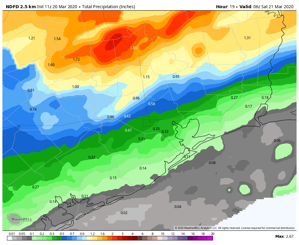
Things change again Saturday afternoon. Today’s cold front is coming back north tomorrow as a warm front. Look for a burst of showers or thunderstorms as this passes by from south to north. The heaviest rain may initially be in the Houston area, but as the warm front progresses north, watch for that to quickly shift back into northern counties, so places like the Brazos Valley, Conroe, or Cleveland will see heavier rain chances again late Saturday afternoon into Saturday evening. All the heavier rain should lift even north of there overnight Saturday into Sunday morning.
Rain totals should be around a quarter-inch or less in Houston and points south again. We could see a half-inch to inch or a bit more in northern counties again.

Sunday
The worst of the rain should continue lifting north and well out of the area Sunday morning. During the day, there will be chances of a shower or a thunderstorm, but I think those might be sporadic or isolated enough that most people won’t see much rain after Saturday night. Temperatures will warm from the 60s into the mid-70s at least on Sunday. We could even see upper-70s to near 80 if we get any sun during the afternoon.
Next week
Houston will begin to settle down next week. On Monday, we could see a few showers again but for the most part it should be partly sunny with temperatures in the 70s to near 80 degrees again. After that, it’s off to the races.
Most of next week looks like something more normal for May than March. Each day from Tuesday through Thursday will be a couple degrees warmer than the previous day. Look for low- to mid-80s Tuesday, mid- to upper-80s Wednesday, and warmer than that Thursday. Many locations will likely be seeing their first 90 degree days of the year on Wednesday or Thursday.
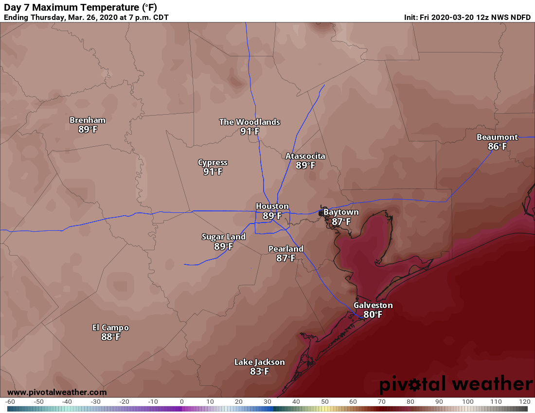
When is our earliest official 90 degree day you ask? Well, much earlier than next week would be. That honor belongs to February 20, 1986 when Houston hit 91°. Last year, we had to wait until April 9th. What’s normal? May 7th has historically been the average for Houston’s first 90° temperature. Either way, it feels too early to be talking about this, but here we are.
Rain chances next week look nil. Our next front? Maybe — maybe next weekend. More on that for you Monday.
90 degrees…in March…I can’t “nope” enough for this. I guess the thermophiles can put away their parkas.
Turned on the A/C yesterday afternoon and thank God it worked. Especially so with me working from home and no church or social activities for the foreseeable future.
I give myself three weeks. Then it will be “They’re Coming to Take Me Away” time.
Turned mine on and it didn’t work. The AC guy is coming this afternoon. 🙁
Good to get it done while you still can. That’s why I just had the car serviced and got a haircut (showered immediately afterwards).
Just keep repeating to yourself, “Hawks, January, Madhouse on Madison; Hawks, January, Madhouse on Madison” . . . . . . .
This might help you cope.
What date was the latest first 90 degree day of the year? Curious on the spread. Also, bring the heat!! 🙂
June 15, 1897…or if you’d prefer something more modern: June 12, 1970 and June 9, 2016. We had a lot of 89s prior to that 90 in 2016 though, if I recall correctly.
Looks like my cigar smoking is about to come to an end until ~October. Bummer.
That was supposed to be a standalone coment instead of replying to another. Sorry.
When is the last time we had a relatively “normal” year and a “below average” year heat wise. The answer to me feels like never.
I think we had a “cool” summer back in the early to mid 90s due to a volcano.
So a cold front moves offshore, then voila, morphs to a warm front and reverses course. No wonder weather forecasting in the area is so “interesting.” The Gulf has a “big opinion” in the matter.😅(Note the bead of sweat on the emoji)
As always, thanks for the no-hype style guys!
1.27” so far. Looks like a decent band headed here but I’m not getting my hopes up
Cold weather is officially over here on the Northside of Houston. The pecan trees are all leafed out and as my mother always said, “you can’t fool a pecan”..
Heat and humidity kill viruses, so bring it on!