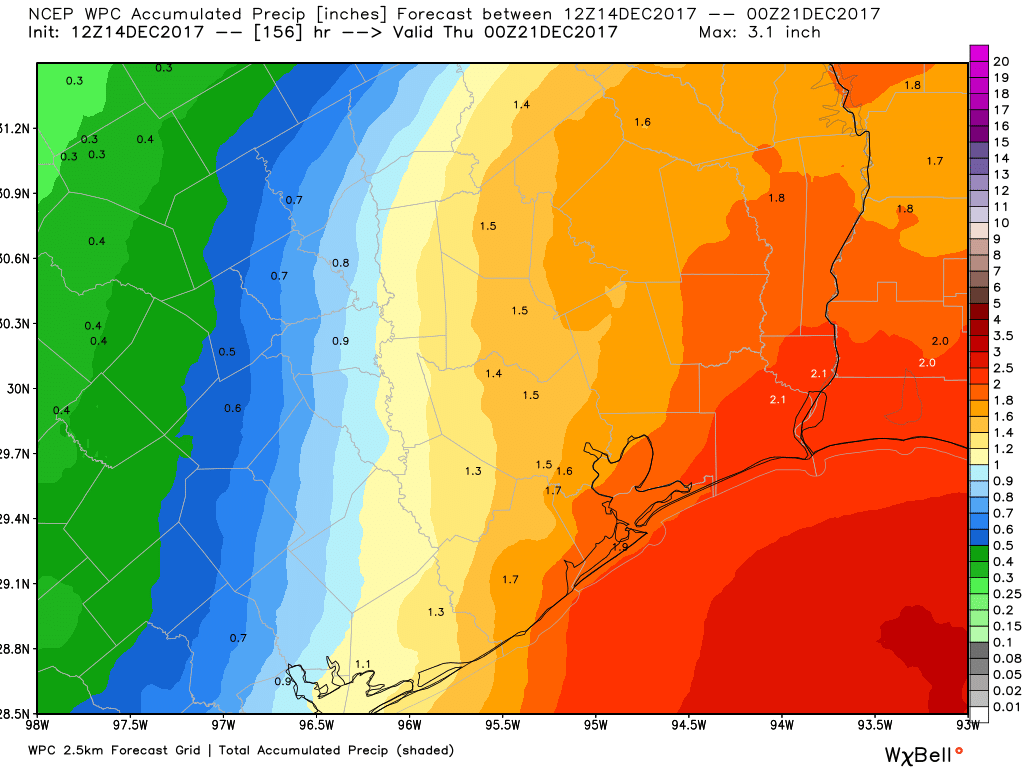
After a week without rainfall, the region will see some decent rain chances over the next several days. That’s not to say we are going to see a total washout, but there’s the potential for a solid 1 to 2 inches of rainfall between now and next Wednesday, with isolated areas seeing a little more. Let’s take a more detailed look at the forecast.
Thursday
Today will be the last day with a near zero chance of rainfall, even as a cold front moves through later on this afternoon. Look for partly to mostly cloudy skies, with a high temperature in the mid- to upper-60s. This is pretty typical weather for December.
Friday
After the front we may see some scattered showers tonight, with rain chances best to the south of Houston, from Galveston down the coast to Matagorda Bay. Most likely, central parts of Houston won’t see much if any rain on Thursday night and Friday morning. The day itself will be cold, with highs likely remaining in the 50s under mostly cloudy skies. Overnight lows on Friday will fall into the low 40s for most of Houston, with upper 30s for inland areas in Montgomery County, and warmer conditions along the coast.
(Space City Weather is brought to you this month by the Law Office of Murray Newman)
Saturday and Sunday
It’s not the best forecast for the weekend, I’m afraid. Saturday will start out cool and cloudy, and I don’t expect much in the way of rainfall during the morning hours. But that should change later in the day, and especially during the overnight hours when the upper-level pattern will combine with warmer air and Gulf moisture to bring showers to a region from Matagorda Bay through most of Louisiana.
For now, it appears the most favorable dynamics for strong thunderstorms will be to the east of Houston. However, I still expect the Houston region to pick up between 0.5 and 1.5 inch of rain between Saturday evening and Sunday morning. After the storms end on Sunday the skies should remain mostly cloudy. With the warmer air moving in from the coast on Saturday night, we can expect highs on Sunday to rise to near 70 degrees.
Monday and Tuesday
Rain chances won’t evaporate altogether—I’d broad brush your chance of seeing a shower during this time frame at about 20 percent—but for the most part I think we’re going to see partly sunny weather, with highs in the upper 60s.
Christmas holiday
The usual caveats apply to a forecast that is still 11 days away, but the forecast models still generally agree that the most likely scenario is warmer weather through most of next week, with a strong cold front arriving sometime in the Dec. 22 to Dec. 24 time frame. This scenario is far from locked in, but right now I’d bet on cold and potentially wet for Christmas Day itself.
Though I know it’s way too far in advance to say for sure… I’m hearing some of the models are showing possible frozen precipitation in the days before Christmas, possibly including Christmas Eve. I think what I saw earlier had 7 of the 22 models showing some sort of frozen precept.
Is the pattern setting up very similar to what it was last week when we had snow?
Beaumont meteorologists keep posting about the GEFS showing snow right before Christmas. Any truth to this or just wishful thinking?
Based on the timing of your comment about the 00z run, you’re looking at last night’s run. Besides, that’s inaccurate anyway. None of the last four GFS runs have (literally) shown freezing rain in Houston. If it’s showing freezing rain and we’re within 2-3 days, we can start being concerned.