After an autumn that has seen Texas slip into drought and cooler weather than we’ve had the last couple years, we’re now adding a more active pattern with a few more rain chances to boot. A lot to cover, so let’s dive in.
Today
Today is a day where we need two or three forecasts for the area. You can see that on this satellite image from this morning.
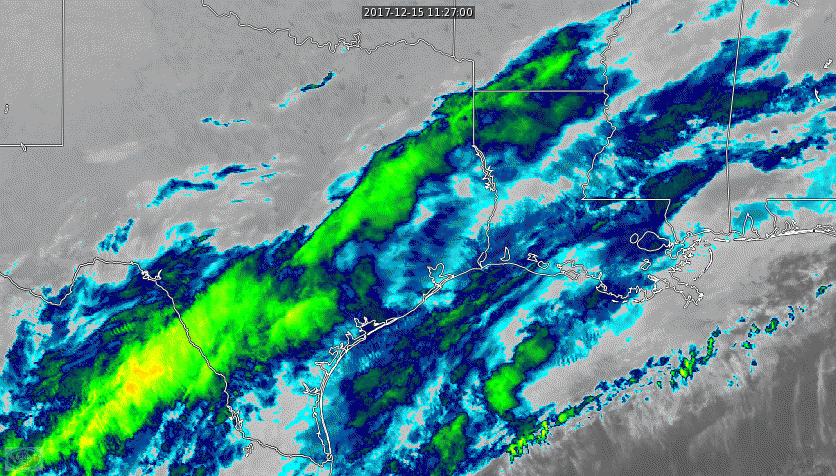
At the coast: Expect clouds and a chance of showers or periods of light rain. The steadier rain will stay offshore, but if you live within 20 miles of the Gulf, you will probably see some raindrops at times today, especially in the morning. Inland from there, including most of the Houston metro area, we’ll just be cloudy. Some light rain or drizzle is possible southeast of town in the morning, and some sunshine is possible in Houston and northwest during the afternoon. Further northwest of Houston, expect a mix of sun and clouds to develop. Temperatures will range from the mid-50s south and east to the mid or upper-50s with clouds and sun north and west.
Saturday and Sunday
Saturday will see a change, as a brief surge of onshore flow leads to increasing rain chances as the day goes on. If you have outdoor plans, the morning might be your safest bet. Expect scattered showers or thunderstorms to break out from west to east Saturday afternoon and evening as a cold front approaches. Rain may be briefly heavy at times, along with some strong or even severe thunderstorms (mainly south and east of Houston) overnight Saturday. Right now, any severe weather looks pretty isolated and mainly east of the area. If this changes, Eric or myself will update you tomorrow.
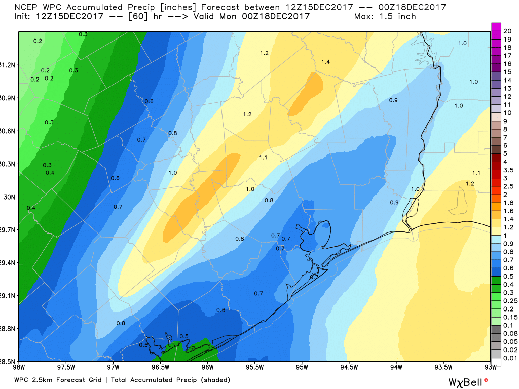
Rain should quickly end from west to east across the area probably between about 12 and 3 AM Sunday. The exception to this may be along the coast, where a few showers will linger through Sunday morning. Total rainfall for this event will probably be a half inch to an inch on average, with a few spots perhaps picking up one to two inches of rain.
Temperatures will top off in the upper 50s Saturday afternoon, then drop off behind the front Saturday night into the lower-50s. Sunday should see improving conditions with a bit of sunshine and highs in the mid to upper-60s.
(Space City Weather is brought to you this month by the Law Office of Murray Newman)
Monday through Wednesday
Moving right along…
The forecast has shifted a bit more pessimistically for early next week. I expect another upper level disturbance to quickly push through the area Monday afternoon or evening. With it, another round of showers and perhaps some thunder.
Tuesday and Wednesday are a little more challenging to pin down still. Models differ, with some clearing us out and ending rain risk, while others hang back scattered shower & thunderstorm chances. I would offer a 60% that rain chances will continue Tuesday and end Wednesday, and a 40% chance that we clear out completely late Monday or Tuesday morning. Any additional rainfall from the systems Monday, Tuesday, and/or Wednesday will probably average less than one inch in most spots, but we’ll have to fine tune that as we get closer (a few spots could see more, particularly if rain chances linger into Wednesday). But as of now, the most vigorous disturbance looks like the one on Saturday night and Sunday morning.
Heading into Christmas
Eric’s done a good job keeping you updated and (more importantly) well-grounded as we head toward Christmas. I’ve seen wild conjecture floating around on social media, comments, and elsewhere about ice storms and snow and all you-know-what breaking loose over Texas and Houston. Friends don’t let friends look at 10-12 day operational GFS model runs!
If you’ve read Eric’s posts this week, he’s been telling you probably a cold front, colder temps, and maybe some rain. And that’s the best we can do right now. The weather pattern heading through Christmas looks like a very active one nationally. Unfortunately, that probably means that if your travels are taking you somewhere else or you are receiving guests here in Texas, you and they may have headaches to contend with somewhere between here and there. But it’s downright impossible to get specific with details right now.
For Christmas itself in Houston, I concur with Eric: A cold front is likely sometime in the Saturday through Monday timeframe, which would likely be accompanied by rain or thunderstorms. Ahead of it, warm, with highs in the 70s likely later next week. Behind it, colder (40s and 50s) and breezier, and potentially damp. I would assign odds of 60% that we are below 60° on Christmas Day right now, a 30% chance that we are between 60° and 70° and a 10% chance we go above 70°. But, we have a long way to go before we can iron out specifics in Houston or elsewhere, so stay tuned. We’ll keep you updated through next week.
“Friends don’t let friends look at 10-12 day operational GFS model runs!”
Literally laughed out loud at this. Thank you for not only giving straight facts, but for having a sense of humor to go with them!
“Friends don’t let friends look at 10-12 day operational GFS model runs!”
Haha, love your no drama weather reports! Have been hooked on you guys since Harvey; keep up the good work!