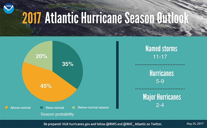
We have reached June 1, which marks the official beginning of hurricane season. You’ve probably seen lots of coverage about how this seems likely to be an “active” season for the Atlantic—however if you actually read NOAA’s forecast it calls for a 55 percent chance of near normal or below normal activity, with a 45 percent chance of above normal. Essentially, that’s 50-50, and not really worth worrying about any more than any other year. Truthfully, if you live near the Gulf coast you should have a plan for when a hurricane threatens (evacuate? where? pets? documents? supplies?), and then put it into place when a storm develops. You can rest assured that we’ll provide comprehensive coverage of any tropical weather that potentially threatens Texas. To that end, we’ll be unveiling a site sponsor for the entirety of the season soon.

Now, onto the forecast.
Thursday
Scattered showers and thunderstorms moved through Houston during the overnight hours dropping from less than a tenth of an inch to more than one inch of rain over western parts of Harris County. These showers have scoured some of the moisture from the air, and we’re likely to see a reprieve from rain through the morning hours. Whether we see some additional rain showers this afternoon will depend upon the extent to which our skies clear out after noon—sunnier skies will lead to warmer temperatures, and this would increase the likelihood of showers later in the afternoon and early evening. Look for highs in the mid-80s.
Friday and Saturday
These should be fairly nice days to start out the month of June, with highs in the upper 80s. I’m looking for partly sunny skies, with the potential for scattered showers and thunderstorms in the afternoon. This is because moisture levels will remain fairly high, allowing for a summer-like incidence of showers during the warmer part of the day. With that said, I don’t expect most people to see much rain.
Sunday
An upper level disturbance will move toward the Houston area by Saturday night or Sunday, and this could provide the impetus for more widespread showers. I’m still not expecting a total washout, but given moisture levels we can probably expect a few areas to see some real downpours. Still, I’d expect overall accumulations to be less than 1 inch for most of the Houston region. Highs in the upper 80s.
Monday and beyond
It looks like we’re going to remain in a pattern such that rain chances, especially during the afternoon hours, linger through the start of next week. It doesn’t look like we’re going to clear out until Wednesday or so, when a cool front may indeed work its way into Houston from the northeast. If this happens we could see a night or two in the 60s, with some drier air. That would be a near miracle for early June, but we’d happily welcome it.
Posted at 7am CT on Thursday by Eric
“BRACE YOURSELVES, THE LAME KATY EVACUATION JOKES ARE COMING” / meme